See a SLIDESHOW of swimming hole photos in this state.
This swimming hole listing is by
www.swimmingholes.org
FEATHERVILLE AREA
[2 PLACES]
(FEAT)
|
|
|---|
|
TOWNS | BOISE, MOUNTAIN HOME, FEATHERVILLE |
|---|
|
STATE | ID |
|---|
|
WATER | Varies-see below |
|---|
|
TYPE | Varies-see below |
|---|
|
DESCRIPTION | Another great western hot/cold dip and camping combination within just a few miles of each other in the Sawtooth N. F.. For details, see DIRECTIONS below. |
|
|---|
|
AREA | Sawtooth N. F. |
|---|
|
SANCTION | Varies-see below |
|---|
|
FEE | Varies-see below |
|---|
|
FACILITIES |
Facilities at the nearby campgrounds |
|---|
|
ACTIVITIES |
Swimming, Hot Springs |
|---|
|
PHONE | Unknown |
|---|
|
CAMPING | At both sites, see below. | |
|---|
|
BATHING SUITS | Varies-see below |
|---|
|
DIRECTIONS | From Boise, take I-84 southwest to Mountain Home the RT 20 north to the area of Dixie. Then take RT 61 northwest toward Pine and Featherville. In Featherville, turn east on RT 227. Then:
WILLOW CREEK [WILL]: Primitive hot spring - soaking spots alongside a trail along Willow Creek in the Sawtooth N. F. with developed N.F. campground nearby. To get there: from Featherville, go 7 miles east on RT 227 to Forest Rd 008. Turn left and go past the Willow Creek Campground about 1.5 miles to the end of the road where there is a horse camp. From here, follow the trail about .5 miles up Willow Creek to the hot springs area. There are a number of different hot soaking pools of different temperatures here. Bathing suits optional, no fee. LAT, LON lat=43.6402, lon=-115.1293(source: Topozone ) (accuracy: approximate) LINK TO GOOGLE MAP. Not verified. Pretty confident. Updated 1/4/2006.
BAUMGARTNER [BAUM]: Somewhat developed hot spring (National Forest) and informal swimming place near Baumgartner Campground. To get there: From Willow Creek (above) continue about 4 more miles east on RT 227 to Baumgartner N. F. Campground. Nearby this campground there is both a swimming hole and a hot spring. The hot spring is led into a concrete pool and managed by the Forest Service - there is a parking fee here. Not sure exactly where the swimming hole is but it is very nearby. There is camping at the campground. LAT, LON lat=43.60583, lon=-115.07528(source: Topozone ) (accuracy: approximate) LINK TO GOOGLE MAP. Not verified. Pretty confident. Updated 1/4/2006.
|
|---|
|
CONFIDENCE | Pretty confident |
|---|
|
VERIFIED | No |
|---|
|
DATE UPDATED | 1/4/2006 |
|---|
This swimming hole listing is by
www.swimmingholes.org
GOLDBUG-SALMON AREA
[2 PLACES]
(GOLA)
|
|
|---|
|
TOWNS | STANLEY, SALMON, NORTH FORK
|
|---|
|
STATE | ID |
|---|
|
WATER | Hot Spring/ Salmon River |
|---|
|
TYPE | Hot Spring/River |
|---|
|
DESCRIPTION | Another outstanding hot-cold pair, nearby each other in central Idaho. See DIRECTIONS below for details.
|
|---|
|
AREA | Salmon N.F. |
|---|
|
SANCTION | Unofficial |
|---|
|
FEE | None |
|---|
|
FACILITIES |
None |
|---|
|
ACTIVITIES |
Hot Tubbing, Swimming |
|---|
|
PHONE | None |
|---|
|
CAMPING | There is very little level land at Goldbug site for primitive camping, likely to be full during busy times. There is established camping nearby Goldbug at Williams Lake. For the Salmon hole, on FR 030, past the Salmon swimming hole, there is camping in the National Forest at Corn Creek (may be full due to rafting). Go south from FR 030 on FR 055 (Panther Creek Rd.) to camp at Deep Creek on Panther Creek, much less crowded than Corn Creek.
|
|---|
|
BATHING SUITS | Optional at Goldbug, Salmon hole is pretty exposed. |
|---|
|
DIRECTIONS |
From RT 93 in Salmon:
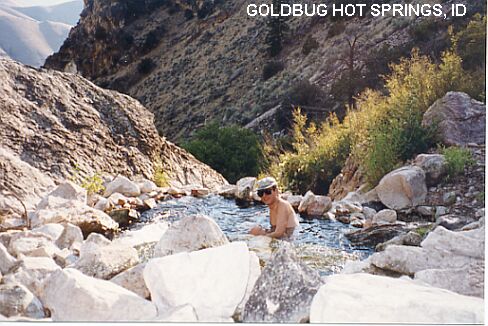
GOLDBUG HOT SPRINGS [GOLD]: At Goldbug Hot Springs, hot waterfall drops through several rock pools in a lush green crevice of a desert hillside. Very beautiful, not sulfurous. Requires a 2 mile hike (each way), steep in parts, but well worth the trip! A hot shower with a spectacular view. To get there: From Salmon, take RT 93 south for 23 miles to mile marker 282. Then go east (left) on a short gravel road to the parking area. Climb over the fence on the south side of the parking area and follow the well used trail. Walk across the footbridge then the trail begins heading uphill. In all, about a 2 mile hike up a canyon, steep at times, following a well established trail. LAT, LON :lat=44.9050, lon=-113.929(source: Web Site) (accuracy:exact). LINK TO GOOGLE MAP. PHOTO , LINK TO VIDEO . Verified. Very confident.
SALMON HOLE [SALM]: If the current isn't too strong, it is a real treat to swim in the legendary Salmon River. Here's remote spot with a fantastic view all around - with a nice sand beach and easy access. BE SAFE, DON'T SWIM IN STRONG CURRENT. To get there: From Salmon, take RT 93 north to North Fork. Go west (left) on FR 030 past Shoup and past the bridge where Panther Creek Road (FR 055) goes off to the left (south). Continue on RT 030 west to where the road crosses a bridge over the Salmon River. Just past this bridge, still on FR 030, there is parking on the left and a large sandy beach on the Salmon River where you may swim in the river IF THE CURRENT IS NOT TOO STRONG. If the beach is under water, you can be sure THE CURRENT IS TOO STRONG! Go down to Goldbug and soak! LAT, LON :lat=45.322644, lon=-114.418036(source: DeLorme) (accuracy: approximate). LINK TO GOOGLE MAP. Verified. Very confident. No photo. |
|---|
|
CONFIDENCE | Very confident |
|---|
|
VERIFIED | Yes |
|---|
|
DATE UPDATED | 11/17/2001 |
|---|
This swimming hole listing is by
www.swimmingholes.org
HOT SPRINGS CAMPGROUND
(HOTS)
| |
|---|
|
TOWNS | BOISE, BANKS |
|---|
| LAT, LON | lat=44.056,lon=-115.911(source: map) (accuracy:approximate)
LINK TO GOOGLE MAP |
|---|
|
STATE | ID |
|---|
|
WATER | Hot Spring/South Fork Payette River |
|---|
|
TYPE | Hot Spring |
|---|
|
DESCRIPTION | Short walk from a Forest Service campground to a series of hot spring pools high on the bank above the South Fork Payette River. Family crowd usually. Some river rafters. For campers, nice place for a night time dip and sky watching. Maybe can climb down and cool off in the river too. |
|---|
|
AREA | Boise N. F. |
|---|
|
SANCTION | Unofficial |
|---|
|
FEE | Fee to camp, none for hot springs |
|---|
|
FACILITIES |
All facilities at campground |
|---|
|
ACTIVITIES |
Hot tubbing |
|---|
|
PHONE | None |
|---|
|
CAMPING | Campground near site |
|---|
|
BATHING SUITS | Customary - family crowd usually |
|---|
|
DIRECTIONS | From Boise, take RT 55 north to Banks (35 miles). Turn east on the Banks/Lowman Highway. From Banks drive 17 miles to the campground. Watch for recreation signs. The hot springs is a short walk from the campground. |
|---|
|
CONFIDENCE | Very Confident |
|---|
|
VERIFIED | No |
|---|
|
DATE UPDATED | 1/2014 |
|---|
This swimming hole listing is by
www.swimmingholes.org
JERRY JOHNSON HOT SPRINGS
(JERR)
| |
|---|
|
TOWNS | MISSOULA MT, MOSCOW ID |
|---|
| LAT, LON | lat=46.46292,lon=-114.87295(source: map) (accuracy:approximate)
LINK TO GOOGLE MAP |
|---|
|
STATE | ID |
|---|
|
WATER | Jerry Johnson Hot Spring/Lochsa River |
|---|
|
TYPE | Hot Spring |
|---|
|
DESCRIPTION | Walk a little more than a mile to one of Idaho's most popular natural hot springs. Three hot springs in a row, each different. Clothing optional is the custom. Not open after sunset. WEB INFO |
|---|
|
AREA | Clearwater N. F. |
|---|
|
SANCTION | Unofficial |
|---|
|
FEE | None for hot springs |
|---|
|
FACILITIES |
All facilities nearby at Jerry Johnson campground |
|---|
|
ACTIVITIES |
Hot tubbing |
|---|
|
PHONE | None |
|---|
|
CAMPING | Nearby at Jerry Johnson campground |
|---|
|
BATHING SUITS | Optional |
|---|
|
DIRECTIONS | From Missoula, MT, travel west on RT 12 over the scenic Lolo Pass and into Idaho. Near mile marker 151 (near Jerry Johnson Campground) is a parking lot and trail that leads south from the suspension bridge over Lochsa River to the hot springs (a little more than 1 mile each way). Parking Area Coordinates: lat=46.46292, lon=-114.87295(source: map) (accuracy:approximate) LINK TO GOOGLE MAP |
|---|
|
CONFIDENCE | Very Confident |
|---|
|
VERIFIED | No |
|---|
|
DATE UPDATED | 9/2014 |
|---|
This swimming hole listing is by
www.swimmingholes.org
JUMP CREEK FALLS
(JUMP)
|
|
|---|
|
TOWNS | BOISE, NAMPA, MARSING |
|---|
| LAT, LON | lat=43.481138, lon=-116.924443(source: map) (accuracy:approximate)
LINK TO GOOGLE MAP |
|---|
|
STATE | ID |
|---|
|
WATER | Jump Creek |
|---|
|
TYPE | Falls |
|---|
|
DESCRIPTION | Easy .5 mile round-trip walk to swimming place in the pool at the bottom of falls in a BLM recreation area. BE CAREFUL OF POISON IVY! BLM INFO , MORE INFO & PHOTOS . |
|---|
|
AREA | Unknown |
|---|
|
SANCTION | Unofficial |
|---|
|
FEE | No |
|---|
|
FACILITIES |
Vault toilet |
|---|
|
ACTIVITIES |
Swimming |
|---|
|
PHONE | Unknown |
|---|
|
CAMPING | No camping at site |
|---|
|
BATHING SUITS | Unknown |
|---|
|
DIRECTIONS | From Boise, take I-84 west to Exit 33A (Nampa) and take RT 55 going west through Marsing. Continue straight onto RT 95 and go about go about 3.5 miles west on RT 95 then turn south (left) on S. Jump Creek Rd. (very near W. Thompson Rd.). On S. Jump Creek Rd. just after passing under power transmission lines, the road curves right - stay on the road as it curves back to the left toward the entry to the recreation area. All told, it is about 5 miles on Jump Creek Rd. from RT 95. |
|---|
|
CONFIDENCE | Pretty confident |
|---|
|
VERIFIED | No |
|---|
|
DATE UPDATED | 1/2014 |
|---|
This swimming hole listing is by
www.swimmingholes.org
LAIRD PARK
(LAIR)
|
|
|---|
|
TOWNS | MOSCOW, HARVARD |
|---|
| LAT, LON | lat=46.94306, lon=-116.64889(source: web site) (accuracy:exact)
LINK TO GOOGLE MAP |
|---|
|
STATE | ID |
|---|
|
WATER | Palouse River |
|---|
|
TYPE | River |
|---|
|
DESCRIPTION | Swimmin place in dammed river (built by CCC) with sandy beach at park/campground. |
|---|
|
AREA | Saint Joe N.F. |
|---|
|
SANCTION | Unknown |
|---|
|
FEE | No |
|---|
|
FACILITIES |
At campground |
|---|
|
ACTIVITIES |
Swimming |
|---|
|
PHONE | Unknown |
|---|
|
CAMPING | Camping at site |
|---|
|
BATHING SUITS | Required |
|---|
|
DIRECTIONS | From Moscow, go north on RT 95 then east (right) on RT 6 for 3 miles then 1.5 mi. southeast on Forest Rd. 447 (Palouse River Rd) to the campground sign. The swimming hole is in a creek in or near the campground. |
|---|
|
CONFIDENCE | Pretty confident |
|---|
|
VERIFIED | No |
|---|
|
DATE UPDATED | 12/29/2007 |
|---|
This swimming hole listing is by
www.swimmingholes.org
MCCALL AREA
[2 PLACES]
(MCCA)
|
|
|---|
|
TOWNS | MCCALL, CASCADE, WARM LAKE |
|---|
|
LAT, LON | lat=44.9103, lon=-116.0661(source: DeLorme) (accuracy:general area)
LINK TO GOOGLE MAP |
|---|
|
STATE | ID |
|---|
|
WATER | Varies - see below |
|---|
|
TYPE | Varies - see below |
|---|
|
DESCRIPTION | Beautiful and cold swimming holes in the forests around McCall. For details, see DIRECTIONS below.
|
|---|
|
AREA | Varies - see below |
|---|
|
SANCTION | Unofficial |
|---|
|
FEE | Unknown |
|---|
|
FACILITIES |
Unknown |
|---|
|
ACTIVITIES |
Swimming |
|---|
|
PHONE | Unknown |
|---|
|
CAMPING | National Forest campgrounds nearby, Ponderosa S. P. near McCall |
|---|
|
BATHING SUITS | Unknown |
|---|
|
DIRECTIONS | From McCall:
SNOWSLIDE [SNOW]: Granite outcropping in very picturesque area that forms a pool with water clear and cold. To get here from McCall: Go north on Davis street then east (right) on Lick Creek Rd. Drive about 13 miles on Lick Creek Rd. (becomes dirt) past the Black Lee Creek trailhead on the left. Before you come to the Snowslide Lake trailhead on the right, look at the stream on the right for a granite outcropping with a pool below. LAT, LON lat=44.99714, lon=-115.94800(source: DeLorme) (accuracy:approximate)
LINK TO GOOGLE MAP. Not verified. Pretty confident. Updated 10/4/04.
KNOX [KNOX]: Wide stream, full of pools with sandy bottoms and grassy places for picnicking. Near Warm Lake east of Cascade. To get here from McCall, go south on RT 55 to Cascade. Turn east (left) on Warm Lake Rd. - FR 22. Just before you reach Warm Lake, turn north (left) on a single lane, paved road along the South Fork of the Salmon River. Turn here and park right away. There is an embankment above the road away from the river. Walk up this hill and cross a wood fence around a meadow at Knox Ranch, a historic mining settlement. Walk south down a hill, away from the meadow to a wide stream, full of pools with sandy bottoms and grassy places for picnicking. LAT, LON lat=44.6649, lon=-115.6973(source: DeLorme) (accuracy:approximate)
LINK TO GOOGLE MAP. Not verified. Pretty confident. Updated 10/4/04.
|
|---|
|
CONFIDENCE | Pretty confident |
|---|
|
VERIFIED | No |
|---|
|
DATE UPDATED | 10/4/2004 |
|---|
This swimming hole listing is by
www.swimmingholes.org
OLD DAM ROPE SWING
(OLDS)
|
|
|---|
|
TOWNS | BOISE, EMMETT |
|---|
| LAT, LON | lat=43.925995
, lon=-116.442847(source: map) (accuracy:approximate)
LINK TO GOOGLE MAP |
|---|
|
STATE | ID |
|---|
|
WATER | Payette River |
|---|
|
TYPE | River |
|---|
|
DESCRIPTION | Short walk to rope swing on steep bank of Payette River. Use a long stick to capture the rope and swim toward shoe quickly as soon as you hit the water. |
|---|
|
AREA | Unknown |
|---|
|
SANCTION | Unofficial |
|---|
|
FEE | No |
|---|
|
FACILITIES |
Unknown |
|---|
|
ACTIVITIES |
Swimming, Rope Swing |
|---|
|
PHONE | None |
|---|
|
CAMPING | No camping at site |
|---|
|
BATHING SUITS | Unknown |
|---|
|
DIRECTIONS | From Boise, take RT44 west to I-84 west past Eagle to the intersection with RT 16 (Emmett Hwy). Take RT 16 north (right) to Emmett. In Emmett turn right on S. Substation Rd. then turn right again on Waterwheel Rd.. Go left on N. Plaza Rd. and follow it along the Payette River then (just before you cross the river) go right on Old Dam Rd. The trail to the rope swing is on the left. |
|---|
|
CONFIDENCE | Pretty confident |
|---|
|
VERIFIED | No |
|---|
|
DATE UPDATED | 1/2014 |
|---|
This swimming hole listing is by
www.swimmingholes.org
ST ANTHONY SAND BAR
(SASB)
| |
|---|
|
TOWNS | IDAHO FALLS, REXBURG, ST ANTHONY |
|---|
| LAT, LON | lat=43.965168, lon=-111.6791(source: map) (accuracy:approximate)
LINK TO GOOGLE MAP |
|---|
|
STATE | ID |
|---|
|
WATER | Henry's Fork of the Snake River |
|---|
|
TYPE | River beach |
|---|
|
DESCRIPTION | Long time, in-town, sand beach for swimming in the river. Has diving board and swim platform and (maybe) a water slide. No lifeguards - swim at your own risk. DO NOT GO IN WHEN THE RIVER LEVEL IS HIGH - PEOPLE HAVE DROWNED HERE AT HIGH LEVELS. |
|---|
|
AREA | Unknown |
|---|
|
SANCTION | Semi-official |
|---|
|
FEE | None |
|---|
|
FACILITIES |
Picnic shelter, toilets |
|---|
|
ACTIVITIES |
Swimming |
|---|
|
PHONE | None |
|---|
|
CAMPING | None at site |
|---|
|
BATHING SUITS | Required |
|---|
|
DIRECTIONS | From Idaho Falls, go northeast on RT 20 through Rexburg to St Anthony. Take the St. Anthony downtown exit. Go north on Bridge St. Turn Right on Main St. Turn Right on N 3rd E. Park is at the end of 3rd on the right hand side. |
|---|
|
CONFIDENCE | Very Confident |
|---|
|
VERIFIED | No |
|---|
|
DATE UPDATED | 1/2014 |
|---|
This swimming hole listing is by
www.swimmingholes.org
SWINGING BRIDGE BEACH
(SWIN)
| |
|---|
|
TOWNS | BOISE, CASCADE, MCCALL |
|---|
| LAT, LON | lat=44.211786, lon=-116.106442(source: Web site) (accuracy:approximate)
LINK TO GOOGLE MAP |
|---|
|
STATE | ID |
|---|
|
WATER | Payette River |
|---|
|
TYPE | River beach |
|---|
|
DESCRIPTION | Swimming hole in river with sandy beach and large flat rocks to sun on. Pretty calm spot for a river. |
|---|
|
AREA | National Forest |
|---|
|
SANCTION | Unofficial |
|---|
|
FEE | None |
|---|
|
FACILITIES |
None at site, at NF campgrounds just south of here. |
|---|
|
ACTIVITIES |
Swimming |
|---|
|
PHONE | None |
|---|
|
CAMPING | At NF campgrounds just south of here. |
|---|
|
BATHING SUITS | Customary (close to road and railroad) |
|---|
|
DIRECTIONS | From Boise, go north on RT 55 about 50 miles. Shorty after you pass 3 NF campgrounds (Swinging Bridge, Cold Springs and Canyon) look for a swinging foot bridge over the river on the right side then look for a pullout also on the right side. Park here, cross the bridge and walk north along the railroad tracks to a sandy beach area with large flat rocks. |
|---|
|
CONFIDENCE | Pretty Confident |
|---|
|
VERIFIED | No |
|---|
|
DATE UPDATED | 1/2013 |
|---|
This swimming hole listing is by
www.swimmingholes.org
THOUSAND SPRINGS S. P.
[4 PLACES]
(THOU)
| |
|---|
|
TOWNS | BOISE, MOUNTAIN HOME, GOODING, BLISS, HAGERMAN |
|---|
| LAT, LON | lat=42.83647, lon=-114.8937(source:map) (accuracy:general area)
LINK TO GOOGLE MAP |
|---|
|
STATE | ID |
|---|
|
WATER | Snake River and others |
|---|
|
TYPE | River/Creek/Spring |
|---|
|
DESCRIPTION | Thousand Springs S. P. is in southern Idaho, southwest of Boise off I-81 and has 5 non-contiguous areas with several swimming places. See DIRECTIONS below for details. State Park Web Site . Article about swimming here. Read the article for details about swimming here. Get local information when you get here. There are said to be (unofficial, no lifeguards) swimming opportunities at
*Box Canyon Springs (hike, unknown length)
*Ritter Island (no hike, drive past hydroelectric plant, is a picnic area)
*Vardis Fisher Lake (locally called "Hidden Lake", a long time local swimming place)
*Blue Heart Springs (access only by boat, contact "1,000 Springs Boat Tours" Hagerman, ID, 208-837-9006 for info - cold, clear water) |
|---|
|
AREA | Thousand Springs S. P. |
|---|
|
SANCTION | Unofficial |
|---|
|
FEE | Yes, see web site |
|---|
|
FACILITIES |
Unknown |
|---|
|
ACTIVITIES |
Swimming |
|---|
|
PHONE | 208-837-4505 |
|---|
|
CAMPING | West on I-84 is Three Island Crossing S. P. with developed camping |
|---|
|
BATHING SUITS | Unknown |
|---|
|
DIRECTIONS | From Boise, go east on I-84 (past Three Island Crossing S. P. - camping) to Exit 141, then go south on RT 30 to Hagerman. Stop at the State Park office at 1074 E. 2350 S. in Hagerman and get information and maps. No further directions. |
|---|
|
CONFIDENCE | Pretty confident |
|---|
|
VERIFIED | No |
|---|
|
DATE UPDATED | 1/2014 |
|---|
HOME
|