UTAH SWIMMING HOLES |
Click here to see the home page and learn about swimming holes in other states
See a SLIDESHOW of swimming hole photos in this state.
This swimming hole listing is by www.swimmingholes.org
|
TOWNS | ST. GEORGE, ZION N.P., BRYCE CANYON N.P., ESCALANTE |
STATE | UT |
WATER | Calf Creek |
TYPE | Creek/Falls |
DESCRIPTION | America's newest National Monument is an awesome desert
landscape and it sure is hot about half the year. Fortunately, in the heart
of the Grand Staircase-Escalante N.M. is Calf Creek with camping, pools and
falls to cool the fevered brow. Take plenty of drinking water and respect
the land (and look in your boots to be sure a scorpion hasn't taken up
residence while you were swimming!) (See also ZION AREA and CAPITOL REEF
AREA nearby.) See "DIRECTIONS" below for details. |
AREA | Grand Staircase-Escalante N.M. |
SANCTION | Unofficial |
FEE | Day use fee |
FACILITIES |
Rest rooms, picnic tables (in campground) |
ACTIVITIES |
Swimming |
PHONE | Unknown |
CAMPING | Camping at site in Calf Creek Campground. |
BATHING SUITS | Customary, may be optional at Upper Falls (very
remote) |
DIRECTIONS | From Bryce Canyon N.P. take RT 12 to the northeast
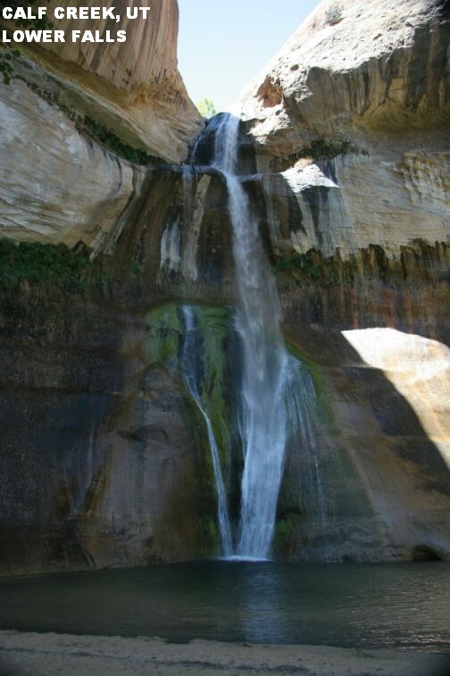
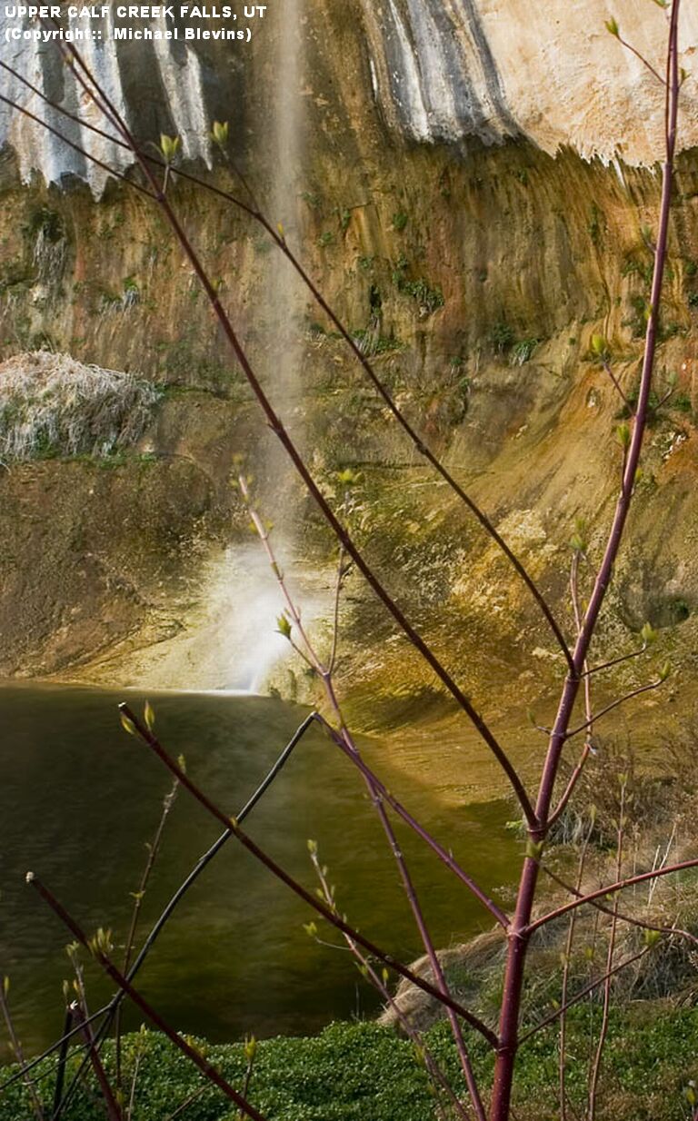
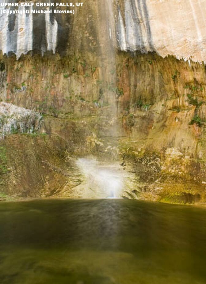
until you get to Calf Creek Recreation Area (well signed). Then: | CALF CREEK CAMPGOUND [CALC]: There is a pretty nice swimming hole with rope swing in Calf Creek right in the middle of the campground. Nice family place, lots of kids, easy access. May be shallow late in season. Park at campground (may be crowded on weekends)and pay day use fee. Swimming place is near the rest rooms. LAT, LON : lat=37.79324, lon=-111.41449(source: DeLorme) (accuracy:approximate) LINK TO GOOGLE MAP . Very confident. Verified. Updated 8/9/2006. CALF CREEK - LOWER FALLS [CALL]: Beautiful falls which drop 126 feet into a cool (cold?) desert swimming pool. LINK TO PHOTO. . PHOTO . Three mile hike each way. Not much elevation change but it can be hot and much of it is on a sandy trail which is tiring. Popular hike, lots of people on weekends. Park at campground (may be crowded parking on weekends)and pay day use fee. Follow the well-marked trail north about 3 miles (each way) to the waterfall. May be shallow late in season. LAT, LON : lat=37.8290 , lon=-111.4209(source: DeLorme) (accuracy:exact) LINK TO GOOGLE MAP . Very confident. Verified. Updated 8/9/2006. CALF CREEK - UPPER FALLS [CALU]: (Description and directions from BLM document:) "A short, steep, strenuous hike to a lush desert oasis of thick stream-side vegetation, hanging gardens, deep pools, and the 87-foot high Upper Calf Creek Falls." Some or all of the pools may be too shallow to swim late in season. PHOTO 1, PHOTO 2. LAT, LON : lat=37.8557, lon=-111.4530(source: DeLorme) (accuracy:exact) LINK TO GOOGLE MAP . Very confident. Verified. Updated 8/9/2006. "To get to trailhead, continue on RT 12 east (past the Calf Creek Recreation Area/Campground, above). Before you get to Boulder, look sharply for the unmarked dirt road to the trail head located on the north (left) side of the road between mile markers 80 and 81. A good landmark indicating that you have the right road is a large black boulder with a wide white stripe that sits on the right side of the entrance to the road. It is less than 0.25 mile to the trail head on the dirt road which is very rough, sandy, and recommended for high clearance vehicles only". Park and walk if this road is too rough. "The hike begins on the canyon rim and makes a 500-foot descent down steep slickrock to a sandy trail visible at the bottom of the slope. As you approach the creek, the trail splits. The left side of the fork follows a trail down slickrock ledges and leads to the base of the falls. The right fork stays high and leads to the top of the falls. For more information, detailed maps, and current conditions contact the nearest GSENM visitor center. Day hike. Route is a well-worn sandy path; occasional rock cairns mark the slickrock sections.1.0 mile one-way with a 500-foot elevation change" (Footing seems precarious when you first go out on this slickrock, but if you have good footwear, avoid loose gravel and the rock is dry, the grip is actually pretty good. Follow the cairns across the slick rock face.) SAFETY: "Very steep slickrock at the beginning and end of the hike. Several rocky ledges to negotiate on the section of trail that leads to the base of the falls. Use caution near cliff edges along the section of trail to the top of the falls. Hikers need to watch their footing on steep slickrock to avoid falls, especially when wet. The return hike up the steep slickrock is very strenuous and can be extremely tiring, especially in hot weather. Heat exposure and lack of water are safety concerns along this route. Heat-related injuries and dehydration could be potential problems. Hikers must carry adequate water. Calf Creek is a sensitive riparian area and requires special "Leave No Trace" principles. Camping and fires are not permitted near the falls."
CONFIDENCE | Very confident |
VERIFIED | See above |
DATE UPDATED | 8/9/2006 | |
|---|
This swimming hole listing is by www.swimmingholes.org
|
TOWNS | ST. GEORGE, CEDAR CITY, ESCALANTE |
LAT, LON | lat=38.28467, lon=-111.20586(source: DeLorme)
(accuracy:general area) | LINK TO GOOGLE MAP
STATE | UT |
WATER | Fremont River/Freemont Falls |
TYPE | Falls |
DESCRIPTION | NOTE: As of 7/25/2011, this area is closed to swimming
for the rest of the summer of 2011 due to very high currents and some
near-fatal accidents. | Utah RT 24 goes east out of the Capitol Reef along the Fremont River, going toward Hanksville. As it comes out of the reef, the river tumbles over a waterfall making a large pool below. A great swimming hole with a smooth chute which you reach from a ledge hidden behind the falls. (See also "CALF CREEK AREA" nearby.)
AREA | Capitol Reef N. P. |
SANCTION | Unofficial |
FEE | Unknown |
FACILITIES |
Unknown |
ACTIVITIES |
Swimming, sliding |
PHONE | Unknown |
CAMPING | Camping nearby at Fruita. |
BATHING SUITS | Unknown |
DIRECTIONS | From the town of Escalante (about 100 miles east of
Cedar City), take RT 12 to the northeast to RT 24 to the Capitol Reef
Visitors Center. To reach the waterfall and swimming hole from the Capitol
Reef Visitor Center take RT 24 east for 6.6 miles to mile marker 86.5. There
is a large paved pull-out on the north side of the highway with several
information signs. The waterfall is next to the parking area. The river
tumbles over a waterfall making a large pool below. CAUTION- DO NOT SWIM
HERE IN HIGH FLOW CONDITIONS! | We received this very helpful email from a park ranger in 4/2006:"...regarding the Capitol Reef swimming hole. There's no fee to enter the park as long as you stay on the main highway and not head south down the waterpocket fold area. The main highway includes the swimming hole. there are no facilities at the swimming hole, just a pull off beside the road and then several trails down to the water. just wanted to remind everyone that as this is the desert, the vegetation and soil is very delicate and shouldn't be trampled on at all. please stay on paths. Especially stay off the biological soil crusts!"
CONFIDENCE | Very confident |
VERIFIED | No |
DATE UPDATED | 10/4/2004 | |
|---|
This swimming hole listing is by www.swimmingholes.org
|
TOWNS | SALT LAKE CITY, PARK CITY, HEBER
| LAT, LON | lat=40.52323,
lon=-111.48801(source: DeLorme) (accuracy:approximate) | LINK TO GOOGLE MAP
STATE | UT |
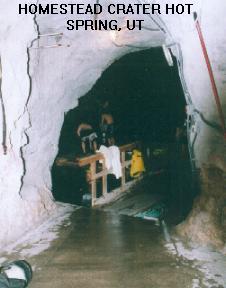
WATER | Homestead Crater Hot Spring |
TYPE | Hot Spring |
DESCRIPTION | A 65 foot deep hot spring inside of a cave where you
can snorkel or scuba in 90 degree water has brought visitors here for over a
century. Now it is a commercial resort with hotel, restaurants, tennis,
sauna, et.al.. The hotel rooms are $120-$170 per night, but it looks like
you can just go to the Crater Hot Spring for $10. It is at 700 North
Homestead Drive, Midway, UT 84049, 435-654-1102, 800-327-7220. Visit their
web site at WEB SITE |
AREA | Homestead Resort |
SANCTION | Official |
FEE | $10.00 |
FACILITIES |
Yes |
ACTIVITIES |
Hot Soaking, Snorkeling, Scuba |
PHONE | (800)327-7220 (Get reservations for hot spring visit) |
CAMPING | No camping at site, there are several national forest
campgrounds nearby on RT 40. |
BATHING SUITS | Required |
DIRECTIONS | From Salt Lake City, take I-80 east to RT 40. Follow US
Route 40 South past RT 248 (RT 248 goes to Park City). (The route from here
is well marked with Homestead Golf Course sign.) About 10 miles from RT 248,
go southwest (take a right) on River Rd. into Midway. Cross Midway on 1050
N. St. & 1100 N. St. and, at the west side of Midway, take RT 224 south -
look for signs to Homestead Resort.
|
CONFIDENCE | Very confident |
VERIFIED | No |
DATE UPDATED | 4/21/2000 | |
|---|
This swimming hole listing is by www.swimmingholes.org
|
TOWNS | LAS VEGAS |
STATE | UT & AZ |
WATER | Lake Powell (Colorado River) |
TYPE | Lake |
DESCRIPTION | The are countless beautiful places to swim in Lake
Powell if you have a boat. There are some also that you can reach by car.
Here are a few of the latter. For details, see DIRECTIONS below. |
AREA | Glen Canyon NRA |
SANCTION | Unofficial |
FEE | None |
FACILITIES |
All facilities at Visitors Centers at Wahweap (AZ) and Bullfrog (UT). Some
facilities at Antelope Point and at other activity centers. |
ACTIVITIES |
Swimming |
PHONE | Unknown |
CAMPING | There are developed campgrounds at Wahweap and Bullfrog and
others, none at Antelope Point (see Wahweap for camping). |
BATHING SUITS | Customary |
DIRECTIONS | See below. | BULLFROG [BULF]: In the UT (northern) section of Lake Powell. There is a marina here and other facilities. There are not any official swim beaches at Bullfrog. However, Hobie Cat beach is a popular swimming area. Visitors will also swim near their camps at the Stanton Creek Primitive Campground. All swimming is at your own risk, there are no life guards on duty. To get directions, look for BULLFROG on the map on the NRA WEB SITE or use these coordinates. LAT, LON: lat=37.52722, lon=-110.72004 source: Map) (accuracy:approximate). LINK TO GOOGLE MAP. Very confident. Not verified. Updated 1/2013. ANTELOPE POINT [ANTL]: In the AZ (southern) section of Lake Powell. There is a marina here, food and other facilities (no camping). There are not any official swim beaches at Antelope. However, There is a nice unofficial swimming place as shown in this video: YOUTUBE. All swimming is at your own risk, there are no life guards on duty. This is near Page in north central Aston get directions, look for ANTELOPE POINT on the map on the NRA WEB SITE or use these coordinates. LAT, LON: lat=36.96351, lon=-111.44128 source: Map) (accuracy:approximate). LINK TO GOOGLE MAP. Very confident. Not verified. Updated 1/2013.
CONFIDENCE | Very confident |
VERIFIED | No |
DATE UPDATED | 1/2013 | |
|---|
This swimming hole listing is by www.swimmingholes.org
|
TOWNS | MOAB |
STATE | UT |
WATER | Varies - see below |
TYPE | Varies - see below |
DESCRIPTION | Swimming holes in the Colorado River and various
canyons near Moab. See DIRECTIONS below for details.
|
AREA | Unknown |
SANCTION | Varies - see below |
FEE | Varies - see below |
FACILITIES |
Varies - see below |
ACTIVITIES |
Varies - see below |
PHONE | Varies - see below |
CAMPING | Varies - see below |
BATHING SUITS | Varies - see below |
DIRECTIONS | All directions are from Moab: | NEGRO BILL CANYON [NEGB]:A 6 mile round-trip hike in a beautiful desert canyon along a creek (with numerous small swimming holes) which ends at Morning Glory Bridge (a natural arch). See HIKING DIRECTIONS & PHOTOS . From Moab, go west on RT 191 then east (right) on RT 128 for 3 miles to the (signed) Negro Bill Trailhead on the right (has toilet). See hiking directions at link above. LAT, LON (Trailhead): lat=38.609736, lon=-109.533617(source: map) (accuracy:approximate) LINK TO GOOGLE MAP. Very confident. Not verified. Updated 1/2014. HAL CANYON [HALC]: Sandy swimming beach on the Colorado River outside Moab. Come early to avoid crowds and bring bug spray and sunscreen. To get here from Moab, go west on RT 191 then east (right) on RT 128 for about 6 miles to, just before Hal Canyon Campground, you see the sandy beach area on the left. LAT, LON: lat=38.639 lon=-109.48(source: map) (accuracy:approximate) LINK TO GOOGLE MAP. Very confident. Not verified. Updated 1/2014. SANDY BEACH ACCESS [SANB]: Sandy swimming beach at a rafting access point on the Colorado River outside Moab. Come early to avoid crowds and bring bug spray and sunscreen. To get here from Moab, go west on RT 191 then east (right) on RT 128 for about 11 miles to the Sandy Beach Access (may be signed). LAT, LON: lat=38.683 lon=-109.477(source: map) (accuracy:approximate) LINK TO GOOGLE MAP. Very confident. Not verified. Updated 1/2014.
CONFIDENCE | Varies -see above |
VERIFIED | No |
DATE UPDATED | 1/2014 | |
|---|
This swimming hole listing is by www.swimmingholes.org
|
TOWNS | PROVO, MONA | LAT, LON (PARKING) | lat=39.79841,
lon=-111.86455(source: map) (accuracy: approximate) | LINK TO GOOGLE MAP
STATE | UT |
WATER | Burriston Ponds |
TYPE | Lake |
DESCRIPTION | Popular place with 2 rope swings into Burriston Pond.
There are two different rope swings at the pond attached to a tree. One is
shorter and one is quite high. Both swings will drop you between 15 and 25
feet into the water below. The pond is deep enough that you don't have to
worry about hitting the bottom and injuring yourself. |
AREA | None |
SANCTION | Unofficial |
FEE | No |
FACILITIES |
Unknown |
ACTIVITIES |
Swimming, rope swing |
PHONE | None
|
CAMPING | Primitive camping may be allowed at the site. |
BATHING SUITS | Customary |
DIRECTIONS | From Provo, go south on I-15 32 miles then take Exit 233
and go west toward Mona. In Mona, take Main St. south (becomes the Mona
Rd.). At the south end of Mona, take Burraston Rd. west (right) and keep
straight on Burraston Rd. as it curves to the right along the pond then
curves to the left at the north end of the pond. Park just after this left
curve (near the north end of the pond) and walk further along the road to
first one rope swing and then the other, both on the east side of the road.
|
CONFIDENCE | Pretty confident |
VERIFIED | No |
DATE UPDATED | 1/2014 | |
|---|
This swimming hole listing is by www.swimmingholes.org
|
TOWNS | ST. GEORGE, VIRGIN, SPRINGDALE |
STATE | UT |
WATER | Varies -see below |
TYPE | River/Creek/Falls |
DESCRIPTION | There are a number of swimming holes in Zion and nearby
- here are a few but you might discover your own too!
ZION WEB SITE . See DIRECTIONS" below for details.
|
AREA | Zion N. P. |
SANCTION | Unofficial |
FEE | Must pay fee to enter Zion N.P. - also you must leave your car
and use their free shuttle bus service if you plan to go up the canyon north
of Canyon Junction. |
FACILITIES |
All facilities at the park. |
ACTIVITIES |
Swimming, Jumping, Tubing |
PHONE | See web site |
CAMPING | At the Springdale entrance to the park there are 2
campgrounds, Watchman and South - only Watchman has reservations. See web
site AND get reservations if you want to camp here. |
BATHING SUITS | Varies-see below |
DIRECTIONS |
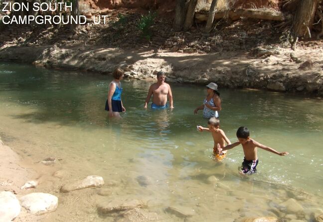
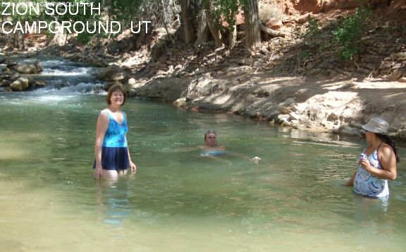
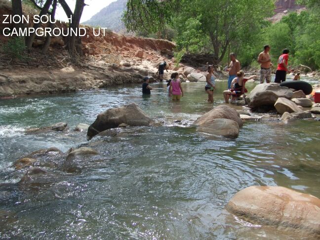
CAMPGROUNDS [CAMP]: The Virgin River goes right by both
the Zion campgrounds - Watchman and the South Campgrounds (both near the
Springdale entrance to the park). There are some fine wading and swimming
places right here in the river - very convenient if you are camping! If you
are not camping, you can access these swimming holes via the PA'RUS trail (a
short walk from the Visitor Center), which skirts the campgrounds along the
Virgin River. An outstanding swimming hole is right behind Site 87 in the
South Campground, PHOTO,
PHOTO , PHOTO, PHOTO
- but there are others too. LAT, LON lat=37.2007, lon=-112.9871(source:
DeLorme) (accuracy: approximate)
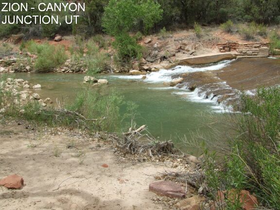
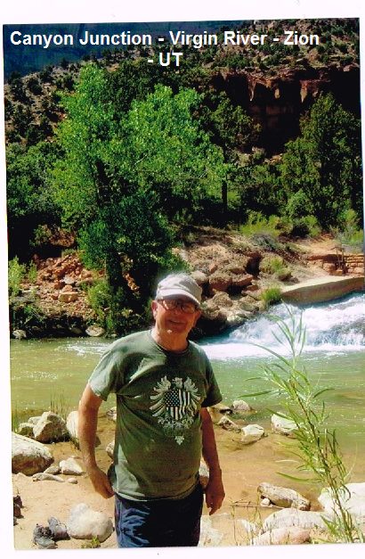
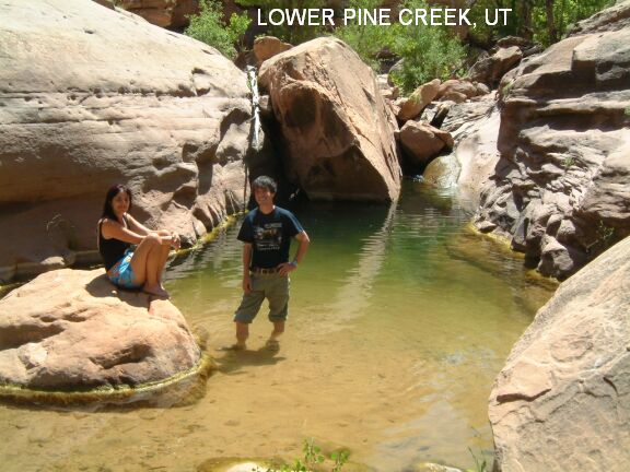
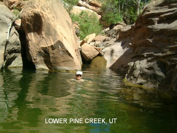
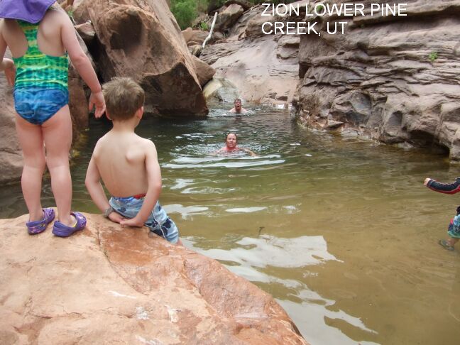
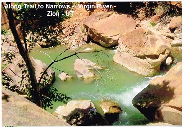
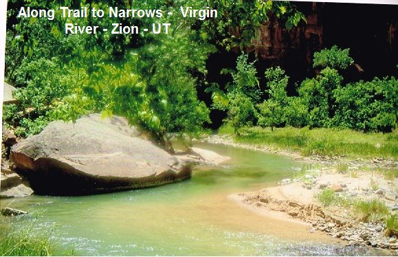
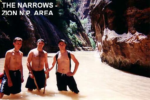
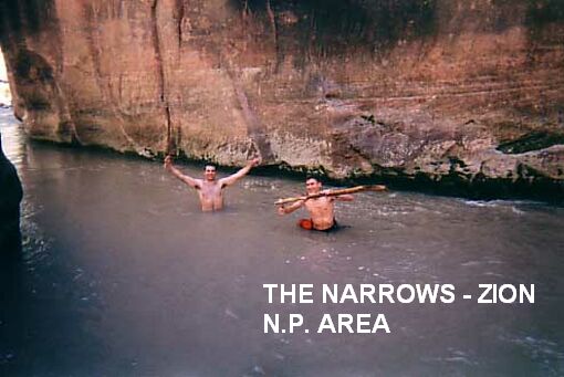
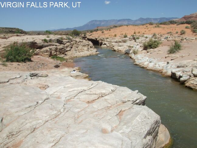
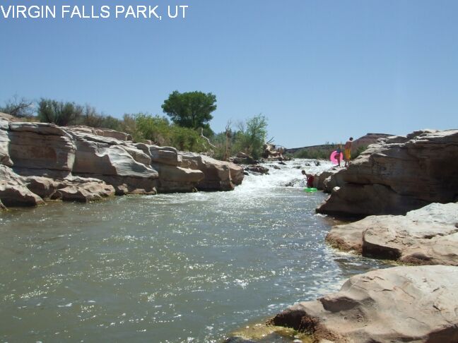
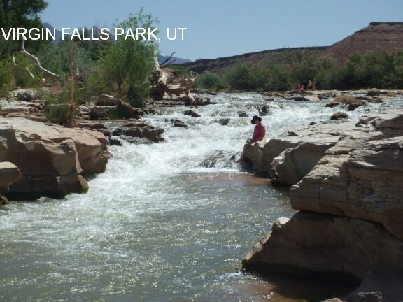
LINK TO GOOGLE MAP. Very confident. Verified 7/2014. Updated 7/2014. | CANYON JUNCTION [CANY]: A popular swimming place in the Virgin River at Canyon Junction, which is also near where Pine Creek joins the Virgin River (see PINE CREEK below). The shuttle bus stops here (and some of the shuttle bus operators even announce the swimming hole!). This is north of the Visitors Center (south of the lodge), where RT 9 turns right to go up the Zion-Mt. Carmel Highway (see the valley map on the web site above). After you get off the shuttle bus at Canyon Junction, walk north short way to the "river access" sign and down to the river to the swimming places. The main swimming hole is just at the bottom of the small falls. PHOTO , PHOTO , PHOTO . LAT, LON lat=37.2189, lon=-112.9729(source: measured) (accuracy: exact) LINK TO GOOGLE MAP. Very confident. Verified 7/2014. Updated 7/2014. LOWER PINE CREEK [LOWP]: An easy hike along Pine Creek (which empties into the Virgin River at Canyon Junction, above) with a couple of swimming holes along the way. LINK TO MORE INFO . To get here by car from Canyon Junction go up (east) on the Zion-Mt Carmel highway a very short distance to the first switchback and park just before the stone bridge over Pine Creek on the left (or, if by shuttle, walk up the road to here from the shuttle stop at Canyon Junction.). To get here, follow a very apparent trail east and into the Pine Creek area for about .5 miles. You will need to cross the creek at least once. At about .5 miles, you will come to a bunch of large boulders blocking the creek - climb over these and the first swimming hole is just on the other side - a nice little falls and deep, narrow, green swimming hole below. You can jump off the rocks on the right into the deepest part of the hole. PHOTO 1, PHOTO 2 , PHOTO 3. LAT, LON lat=37.21737 , lon=-112.96039(source: measured) (accuracy: exact) LINK TO GOOGLE MAP. If you clamber over rocks and go upstream a very short distance from here, you come to Lower Pine Creek Falls, about 10 feet high, but the pool at the bottom tends to be shallow and not as good a swimming place as the first place. It is a bit of a difficult rock clamber to go up to the falls - from the first place climb up the rocks face on the right (looking upstream) using the apparent "steps" in the rock. Clamber over a few boulders and you will see the falls. See link to photos above for the larger falls. Also, if you park at the second switchback, look east over the guard wall and follow a well-maintained path down to the streambed. The path down is steep but not too difficult. The Pine Creek watercourse is strewn with many large boulders which have created many little alcoves, waterfalls, and pools -- fun for hanging out in the water. Very confident. Verified 7/2014. Updated 7/2014. THE NARROWS [NARR]: At the north end of the canyon in Zion is "The Narrows" - where the Virgin River comes out of a deep, narrow canyon. You can get a permit (and a shuttle) and hike the entire Narrows from north to south (usually done as an over night trip). Information about the hike. Most people take a much shorter hike up into the Narrows - take shuttle to the north end of the valley (The Temple of Sinawava)and walk the "Riverside Trail" north. For the first mile, it is paved and there are numerous swimming holes clearly visible as you walk this paved trail - Photo along the walk to the Narrows , Photo along the walk to the Narrows. Then walk north in the Virgin River canyon (sometimes in the water - wear shoes that can get wet); there are also several places deep enough to be swimming holes along here also Photo of hiking in the Narrows , Photo of hiking in the Narrows.. After about 1.5 miles of walking in the river, you come to where the Narrows really begin. Here, on the right, Orderville Canyon comes in. Hike up this canyon about .5 mile and you will come to small falls with several swimmable pools. LAT, LON lat=37.3067, lon=-112.945(source: DeLorme) (accuracy: approximate) LINK TO GOOGLE MAP. Very confident. Partially verified. Updated 6/2007. VIRGIN RIVER FALLS PARK [VIRG]: This one is not in Zion N.P. but is close by and a lot of fun! Near the town of Virgin, there is a town park where the Virgin River goes through a narrow slickrock slot - great for a swim or a short tubing trip (vault toilets). Photo 1 , Photo 2 , Photo 3 . To get here from Zion N.P., take RT 9 west to the town of Virgin. Go about .25 miles past (west of) the Fort Zion Restaurant and turn south (left) on Sheep Bridge Rd.. Cross the bridge over the Virgin River and turn immediately left where there is a sign for the Virgin River Falls Park and a gate. Drive this (rough dirt) road about .4 miles then you will see the toilet and picnic table. Park and walk to the river. Take an inner tube (and sun screen - no shade) and enjoy! LAT, LON lat=37.1975, lon=-113.2083 (source: DeLorme-p) (accuracy: exact) LINK TO GOOGLE MAP. Very confident. Verified 5/2007. Updated 10/2011.
CONFIDENCE | See above |
VERIFIED | Yes, 6/2007 |
DATE UPDATED | 1/2013 | |
|---|
HOME