See a SLIDESHOW of swimming hole photos in this state.
|
This swimming hole listing is by
www.swimmingholes.org
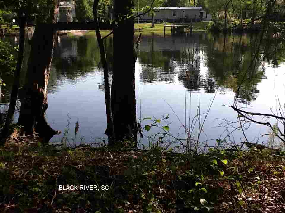
BLACK RIVER
(BLAC)
|
|
TOWNS | ANDREWS |
|---|
| LAT, LON | lat=33.48694, lon=-79.54442(source: DeLorme) (accuracy:general area)
LINK TO GOOGLE MAP |
|---|
|
STATE | SC |
|---|
|
WATER | Black River |
|---|
|
TYPE | River |
|---|
|
DESCRIPTION | Water is completely black. Temperature is perfect
during the summer. Quiet and beautiful. There are several
public places to fish, picnic and swim. |
|---|
|
AREAS | Unknown |
|---|
|
SANCTION | Official |
|---|
|
FEE | No |
|---|
|
FACILITIES |
Picnic tables |
|---|
|
ACTIVITIES |
Swimming, Jumping, Tubing |
|---|
|
PHONE | none |
|---|
|
CAMPING | Unknown |
|---|
|
BATHING SUITS | Optional |
|---|
|
DIRECTIONS | South on RT 17 from Myrtle Beach about 45 mi to Sampit. Then northwest on RT 521 to Andrews. Then north on RT 41 & 513 to the bridge over the Black River. Once you cross the Black River bridge, then take first road to the right. Park at barricade and it is about a 0.5 mile hike to swimming hole. Walk down the road, bearing right on the road as it goes towards the river. Take second left dirt road along the river until you get to the swimming hole marked with a swinging rope out into the water.
|
|---|
|
CONFIDENCE | Very confident |
|---|
|
VERIFIED | By another |
|---|
|
DATE UPDATED | 4/2011 |
|---|
|
|---|
This swimming hole listing is by
www.swimmingholes.org
EDISTO RIVER AREA
(2 PLACES)
(EDIS)
|
|
TOWNS | CHARLESTON, WALTERBORO, ST. GEORGE, CANADYS |
|---|
|
STATE | SC |
|---|
|
WATER | Edisto River |
|---|
|
TYPE | River |
|---|
|
DESCRIPTION | Several swimming places in the Edisto River near the I-95/I-26 interchange. There are alligators in this river - see Alligator safety cautions. See DIRECTIONS below for details. This is also a popular, pretty and easy canoeing section of the Edisto River, from Colleton S.P. downstream to Givhans Ferry S.P.. |
|---|
|
AREAS | Colleton S.P., Givhans Ferry S.P. |
|---|
|
SANCTION | Unofficial |
|---|
|
FEE | None |
|---|
|
FACILITIES |
All facilities at State Parks. |
|---|
|
ACTIVITIES |
Swimming, canoeing |
|---|
|
PHONE | Unknown |
|---|
|
CAMPING | Colleton S. P. and Givhans Ferry S.P. have nicely developed campsites along the Edisto River. |
|---|
|
BATHING SUITS | Required |
|---|
|
DIRECTIONS | From I-95, take Exit 68 (south of I-26, at Canadys) Then:
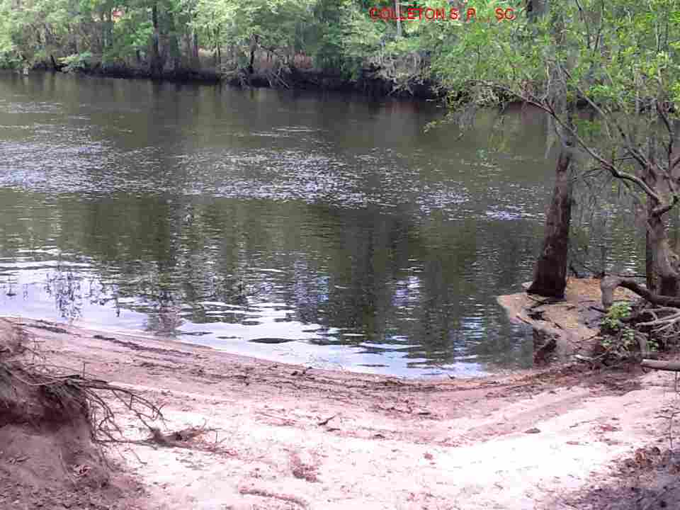
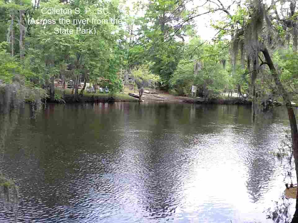
COLLETON S. P. [COLL]: A very lovely southern state park along the darkly tannic Edisto River. Depending on water level, there may be opportunity to swim in the river (unofficial) at the state park. PHOTO . YOUTUBE VIDEO There are alligators around here, so swim at midday and make lots of noise if you go swimming, they are said not to like noise. LAT, LON lat=33.06500, lon=-80.61681(source: DeLorme) (accuracy: approximate) LINK TO GOOGLE MAP.
Here is a report from a fan: "It does depend on how much water is in the river. If you go into the State Park, the water is actually deeper on the other side of the river (across from the park) Last time I was there 3 to 3.5 feet deep on that side. And water was kinda low since we were real short on rain as was the entire east coast. You can park alongside the road by the bridge that goes over the river there (RT 15) and walk to the far side. But I find it a lot safer to park in the State Park and walk across the river. PHOTO . I have been to better places but not around there. It is a great place to cool off, in that area. I grew up in New England so I am kinda spoiled. Another thing down here is Gators. It makes me much more careful where I might swim to cool off." To get here, after you get off I-95 at Exit 68, take RT 61 east and just follow signs to Colleton S. P.-it is very near I-95. Pretty confident. Not verified. Updated 1/15/2004.
|
GIVHANS FERRY S. P. [GIVH]: This is a more popular and inviting swimming place than Colleton. A very lovely southern state park along the darkly tannic Edisto River. Depending on water level, there may be opportunity to swim in the river (unofficial) at the state park. There are wooden steps down to the river beside the park office. A small beach-like area here. There are alligators around here, so swim at midday and make lots of noise if you go swimming, they are said not to like noise. LAT, LON lat=33.02745, lon=-80.38602(source: Map) (accuracy: approximate) LINK TO GOOGLE MAP. Very confident. Verified 3/2013. Updated 3/2013. |
|
|
|---|
|
CONFIDENCE | Very confident |
|---|
|
VERIFIED | Yes |
|---|
|
DATE UPDATED | 3/2013 |
|---|
|
|---|
This swimming hole listing is by
www.swimmingholes.org
HORSESHOE FALLS
(HORS)
|
|
TOWNS | GREENVILLE, SPARTANBURG, CLINTON |
|---|
| LAT, LON | lat=34.59635, lon=-81.85430(source:measured) (accuracy:exact)
LINK TO GOOGLE MAP |
|---|
|
STATE | SC |
|---|
|
WATER | Cedar Shoals Creek |
|---|
|
TYPE | Waterfall |
|---|
|
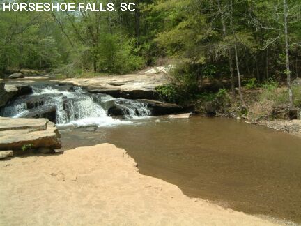
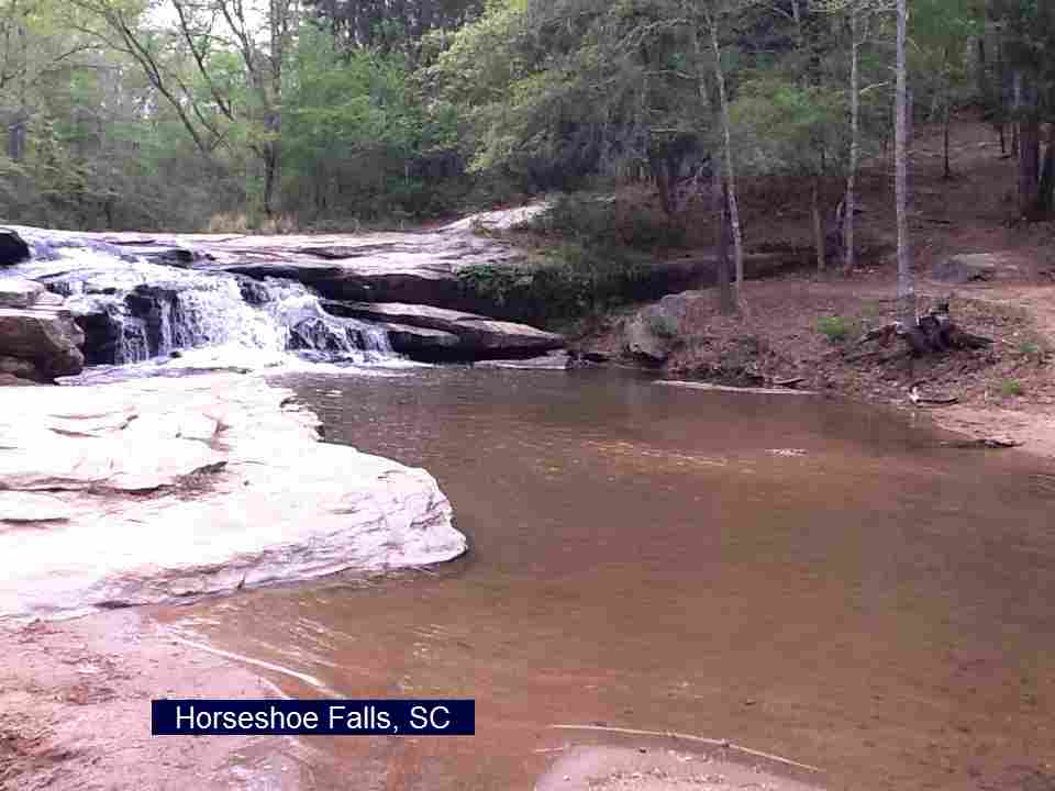
DESCRIPTION | This is a quote from Allen Easler's South Carolina Waterfalls site - photos & info : "Horseshoe Falls (aka Gordons Mill Falls) are on Cedar Shoals Creek just northeast of where the creek joins the Enoree River. The 10-foot high falls have always been a popular picnic area and swimming hole for locals (read: party spot)." The water may not be deep enough to really swim here most times. |
|---|
| AREAS | Musgrove Mill Historic State Park Site (currently being developed) |
|---|
|
SANCTION | Unofficial |
|---|
|
FEE | None |
|---|
|
FACILITIES |
None |
|---|
|
ACTIVITIES |
Swimming, Jumping |
|---|
|
PHONE | None |
|---|
|
CAMPING | None at site |
|---|
|
BATHING SUITS | Customary (very near road) |
|---|
|
DIRECTIONS | "From Exit 52 of I-26 (south of Spartanburg), take RT 56 north toward Cross Anchor. Cross the Enoree River and go approximately one mile up the hill. Take a left onto Horseshoe Falls Road. Horseshoe Falls will be on the left immediately after crossing Cedar Shoals Creek on an old iron truss bridge. Park at the vehicle barricades on the left beside the bridge or on the left at the top of the hill." There is swimming at the bottom of the falls and also another swimming hole (also pretty shallow) accessible from the parking area that is up the hill on the left (where the park information sign is). |
|---|
|
CONFIDENCE | Very confident |
|---|
|
VERIFIED | Yes, 4/04 |
|---|
|
DATE UPDATED | 4/2011 |
|---|
|
|---|
This swimming hole listing is by
www.swimmingholes.org
LEE STATE PARK (LEES)
|
|
TOWNS | FLORENCE, SUMTER |
|---|
| LAT, LON | lat=34.20603, lon=-80.19642(source: DeLorme) (accuracy: exact)
LINK TO GOOGLE MAP |
|---|
|
STATE | SC |
|---|
|
WATER | Spring |
|---|
|
TYPE | Artesian Spring |
|---|
|
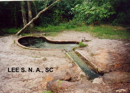
DESCRIPTION | An artesian spring (under natural pressure) spouts clear, cool water into a small 1-2 person pool (made by
Civilian Conservation Corps in 1939) where you can definitely cool of on a hot day in South Carolina. Not big enough to swim.
Comment from the local Ranger :
"We also have another swimming hole that�s
actually a swimming hole. It�s artesian spring fed and is open
Memorial Day to Labor Day. Here are the GPS coordinates: 34.195889
-80.180401"
|
|---|
|
AREAS | Lee State Park |
|---|
|
SANCTION | Official |
|---|
|
FEE | None |
|---|
|
FACILITIES |
All facilities |
|---|
|
ACTIVITIES |
Cooling off |
|---|
|
PHONE | 803-428-5307 |
|---|
|
CAMPING | At site |
|---|
|
BATHING SUITS | Required |
|---|
|
DIRECTIONS | From Florence, take I-20 west to Exit 123 then take RT 22 north a short distance to the park. Drive on the loop road past the family camping area, past the equestrian area to the boy scout camping area. The artesian pool is at the Boy Scout camping area. |
|---|
|
CONFIDENCE | Very confident |
|---|
|
VERIFIED | Yes |
|---|
|
DATE UPDATED | 7/2018 |
|---|
|
|---|
This swimming hole listing is by
www.swimmingholes.org
MOONSHINE FALLS AREA
[4 PLACES]
(MOON)
|
|
TOWNS | GREENVILLE, CLEVELAND |
|---|
|
STATE | SC |
|---|
|
WATER | Varies, see below |
|---|
|
TYPE | Falls |
|---|
|
DESCRIPTION | Several small falls and sliding rocks northwest of Greenville. For details, see DIRECTIONS below. |
|---|
|
AREAS | Varies, see below |
|---|
|
SANCTION | Unofficial |
|---|
|
FEE | None |
|---|
|
FACILITIES |
Nearby State Parks have all facilities |
|---|
|
ACTIVITIES |
Swimming, wading, sliding, water play |
|---|
|
PHONE | Unknown |
|---|
|
CAMPING | AT Table Rock S.P. |
|---|
|
BATHING SUITS | Customary |
|---|
|
DIRECTIONS | From Greenville, go northwest on RT 276. Follow RT 276 through Marietta to where RT 11 joins with RT 276 (set odometer here) and through Cleveland, then proceeding west on RT 276/11 (Cherokee Scenic Hwy):
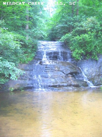
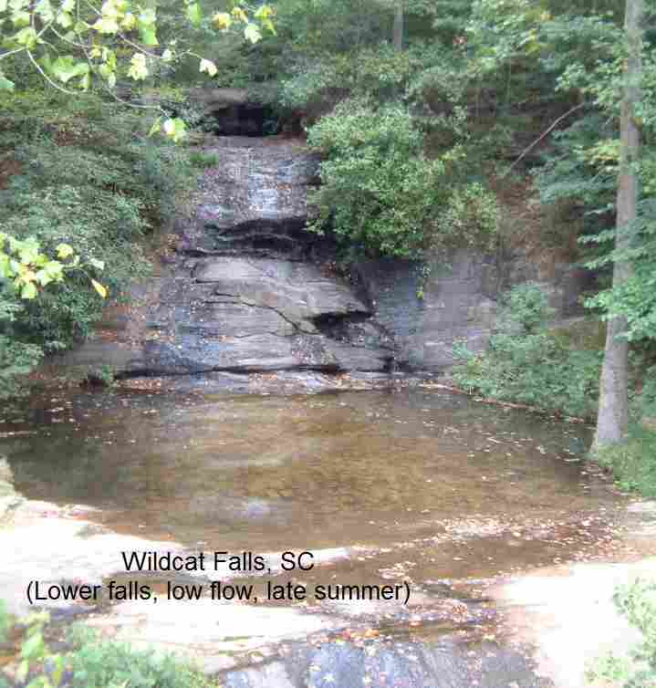
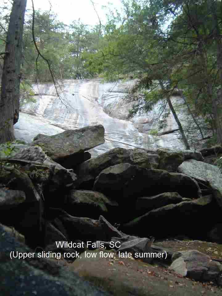
WILDCAT FALLS [WILD]: At the Wildcat Wayside State Park, the popular Wildcat Falls has only a shallow pool at the bottom ( PHOTO , PHOTO ) but if you go up the trail a bit (about .25 mile) above the falls there is a more swimmable pool plus a 130 foot waterslide on a sliding rock. ( PHOTO ) (May be very little water here after a dry summer.) This from a visitor: "Sometimes when I stop it's full of families using it just to take a half hour off from a long drive to cool off. Above the falls, on Wildcat Creek, is a sliding rock and swimming hole that apparently is quite popular with the college kids from upstate SC." LINK TO INFO AND PHOTOS. The lower falls are good for the whole family, the upper sliding rock and pool present some dangers (the slide is very high and you have to climb over huge boulders to get to it) and may not be suitable for children. To get here: Stay on RT 276/11 west for about 5 miles past where RT 11 joins RT 276 and look for a pull off (unsigned) on the right (north) side of the road, which is the Wildcat Wayside State Park. Wildcat Falls is right by the side of the road. To get to the sliding rock up the trail, go up the wooden stairway from the parking area and go right at the top and follow the trail across a bridge for about .25 miles. At the end of the trail, climb over large boulders to reach the bottom of the huge sliding rock. Pretty confident. Verified 9/2011. Updated 9/2011. LAT, LON lat=35.07394, lon=-82.59697(source: DeLorme) (accuracy: approximate)
LINK TO GOOGLE MAP.
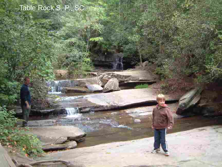
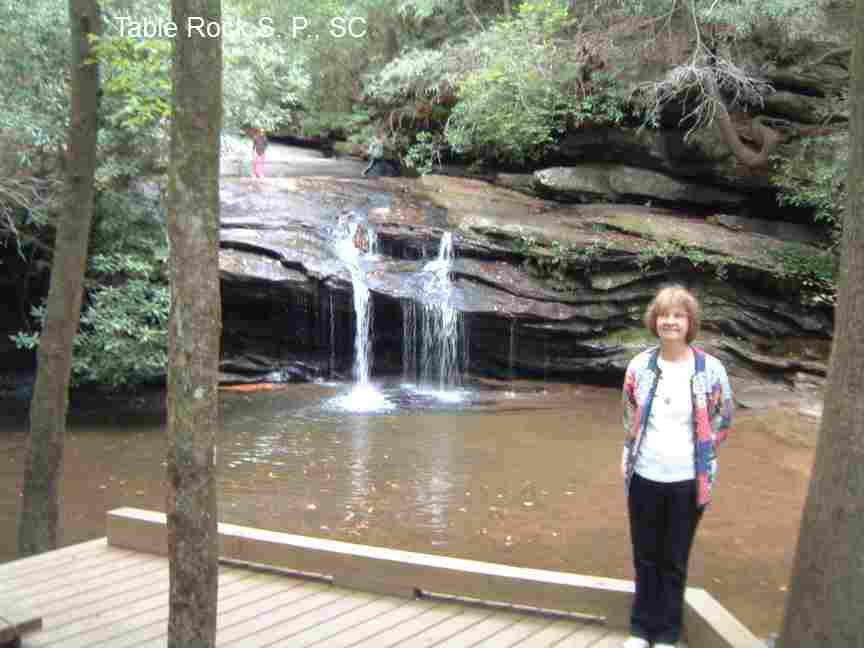
TABLE ROCK S. P. [TABL]: The park has many small waterfalls on Carrick Creek and Green Creek along the 1.9 mile Carrick Creek loop trail. Many of the falls are between 5 to 10 feet high with a small volume flow ( PHOTO ). One place very near the beginning of the trail has a pretty deep pool at the bottom ( PHOTO ). For more photos and more info, see this web site WEB SITE To get here: stay on RT 11 past where RT 276 goes north then follow signs to the State Park. Enter the park and follow the signs to the nature center. Park in the lot across from the nature center and cross the road. Fill out the hiker registration form. The Carrick Creek, Table Rock and Pinnacle Mountain trails all begin behind the nature center. Very confident. Verified 9/2011. Updated 9/2011. LAT, LON lat=35.0315, lon=-82.700(source: DeLorme) (accuracy: approximate) LINK TO GOOGLE MAP.
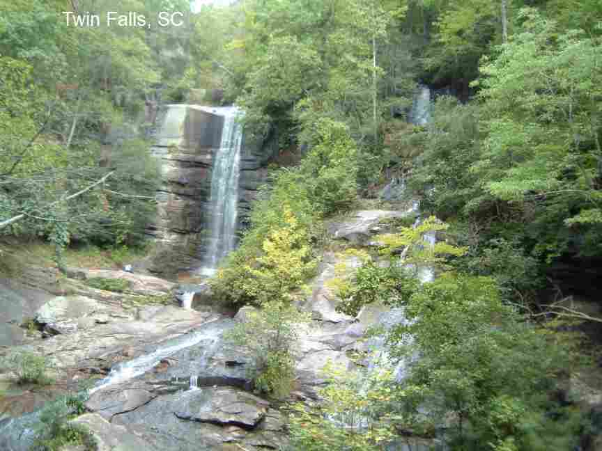
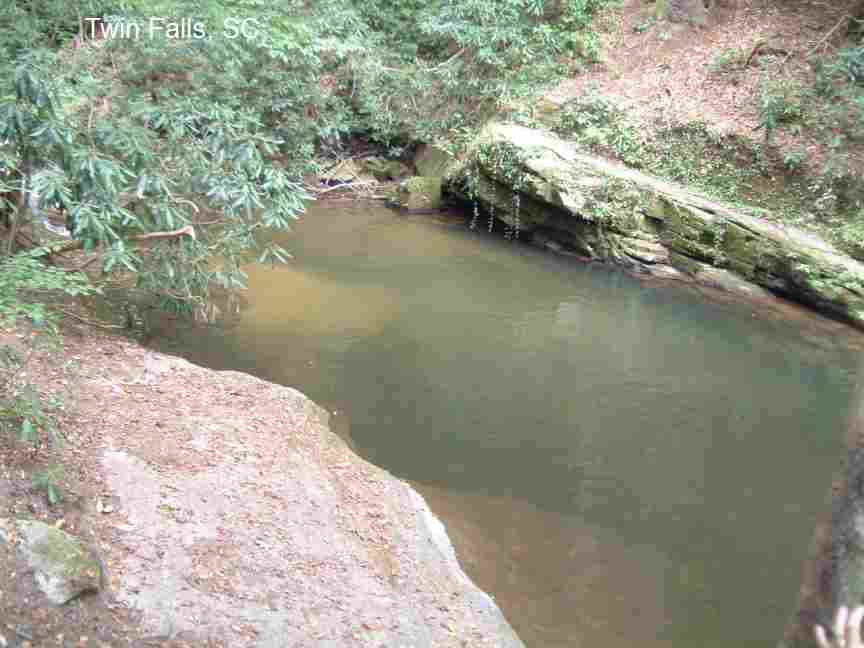
TWIN FALLS [TWIN]:Treat this place gently - absolutely no trash - it is a private preserve and we will loose access to it if it is abused. Beautiful falls Reedy Cove Creek with no pool at the bottom ( PHOTO ), but there is a huge, deep (even in late summer) swimming place ( PHOTO ) along the short path to the falls. To get here: Stay on RT 11 west, past Table Rock State Park and turn north (right) on RT 178. Go about 3.5 miles on RT 178 then turn west (left) onto Cleo Chapman Road (at Bob's Place Tavern) and go 2 miles to a "T" intersection then turn right onto Eastatoe Community Road. Go 1 mile, and turn right onto Waterfalls Road which soon turns to gravel. Stay on this road until it ends at a parking area. Hike down the old roadbed alongside the creek a short way (easy hike). The biggest swimming hole is visible from the trail between the wooden water wheel and the falls themselves. Very confident. Verified 9/2011. Updated 9/2011. LAT, LON lat=35.00899, lon=-82.82076(source: DeLorme) (accuracy: approximate)
LINK TO GOOGLE MAP.
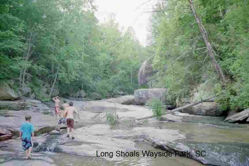
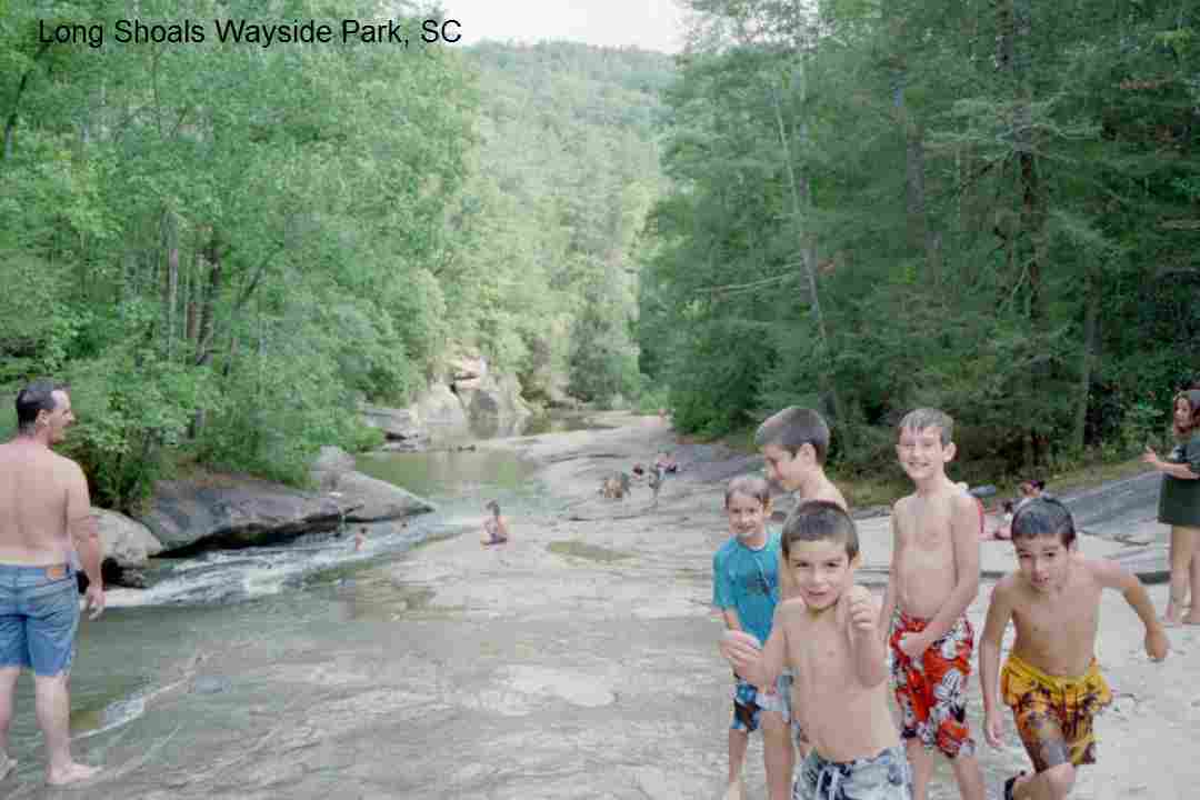
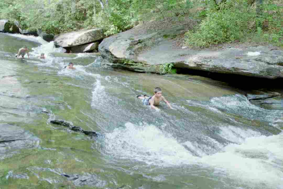
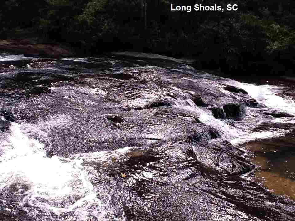
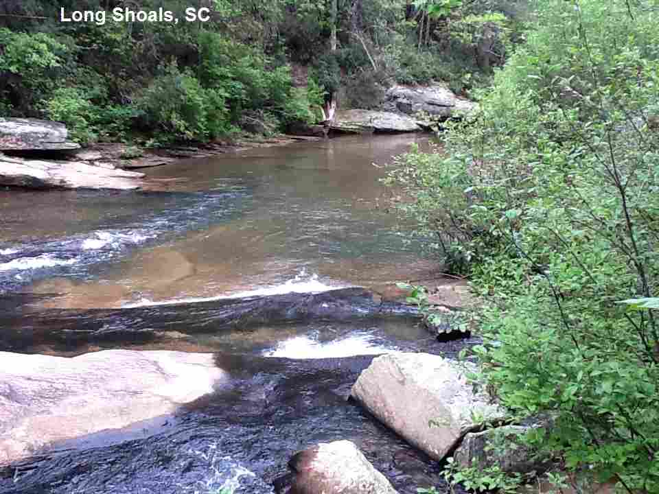
LONG SHOALS WAYSIDE PARK [LONG]:A cascade falls/sliding rock in Little Eastatoee Creek at a nice wayside park and picnic area in Poe Creek State Forest. This is a quote from Allen Easler's South Carolina Waterfalls site - photos & info : "Long Shoals are a popular spot for locals and tourists alike...slide down the rock into the cool waters on a warm summer day. Numerous organizations and community volunteers have transformed this old party spot into Long Shoals Wayside Park with parking, trails, picnic tables, bicycle rack, and a portajohn. From the upper parking lot, follow the "trail" signs down to the Long Shoals. Or, park in the lower lot and take the fishing access trail to an area downstream of the falls." This from a visitor in 2010:"Thought this place should be on your list, lots of fun for the kids to slide down and land in this pool, our 6 to 11 year old boys (5 in total) loved it." PHOTO , PHOTO , PHOTO , PHOTO , PHOTO , YOUTUBE VIDEO. To get here: Continue on RT 11 west of Sliding Rock above and look for signs to Long Shoals Wayside Park. Very confident. Verified 9/2011. Updated 9/2011. LAT, LON lat=34.94822, lon=-82.85211 (source:map) (accuracy:approximate) LINK TO GOOGLE MAP.
|
|---|
|
CONFIDENCE | Very confident |
|---|
|
VERIFIED | Varies-see above |
|---|
|
DATE UPDATED | 9/2011 |
|---|
|
|---|
This swimming hole listing is by
www.swimmingholes.org
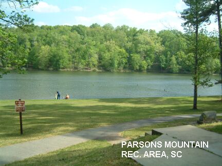
PARSONS MOUNTAIN RECREATION AREA
(PARS)
|
|
TOWNS | AUGUSTA, ABBEVILLE |
|---|
| LAT, LON | lat=34.0973, lon=-82.3564(source:Topozone) (accuracy:exact)
LINK TO GOOGLE MAP |
|---|
|
STATE | SC |
|---|
|
WATER | Lake |
|---|
|
TYPE | Spring fed pond |
|---|
|
DESCRIPTION | This is not really a swimming hole - it is a small lake - but it is such a specially nice for families and kids place we keep it listed. This is the first swimming place that Walden actually visited and swam in (at age 2 1/2) with his grandfather in April 2004. You can camp by a CCC developed swimming hole - a creek-fed pond with swimming. The 1.4-mile Parson's Mountain Hiking Trail is a perfect way to introduce children to the joys of hiking, ending at a fire tower after a moderate 400-foot climb though hardwoods, pine and dry ride scrub oaks. |
|---|
|
AREAS | Sumter National Forest |
|---|
|
SANCTION | Official |
|---|
|
FEE | $3.00 to swim, $7.00 to camp. |
|---|
|
FACILITIES |
All facilities |
|---|
|
ACTIVITIES |
Swimming |
|---|
|
PHONE | 843-229-2406
|
|---|
|
CAMPING | Very nicely developed camping at site. |
|---|
|
BATHING SUITS | Required |
|---|
|
DIRECTIONS | From Augusta, go north on RT 28 toward Abbeville. About 2.1 miles BEFORE you get to Abbeville, see sign for Parsons Mountain Recreation Area and turn east (right) on route SI-251, drive 1.5 miles to entrance on right.
|
|---|
|
CONFIDENCE | Very confident |
|---|
|
VERIFIED | Yes |
|---|
|
DATE UPDATED | 4/29/2004 |
|---|
|
|---|
This swimming hole listing is by
www.swimmingholes.org
SUMTER N. F. AREA
(13 PLACES)
(SUMT)
|
|
TOWNS | WESTMINSTER, WALHALLA |
|---|
|
STATE | SC |
|---|
|
WATER | Varies, see below |
|---|
|
TYPE | Falls/River |
|---|
|
DESCRIPTION | Several swimming places in a portion of the Sumter N. F. in northwestern SC. For details, see DIRECTIONS below. |
|---|
|
AREAS | Sumter N. F. |
|---|
|
SANCTION | Unofficial |
|---|
|
FEE | None |
|---|
|
FACILITIES |
None |
|---|
|
ACTIVITIES |
Swimming |
|---|
|
PHONE | Unknown |
|---|
|
CAMPING | Oconee State Park and Cherry Hill campground, both on RT 107 northeast of Walhalla. Also walk-in developed camping at Burrell Ford and primitive camping at Brasstown Falls. Also very primitive (no facilities) camping at Grapevine (see below). |
|---|
|
BATHING SUITS | May be optional, depending on crowd. |
|---|
|
DIRECTIONS | From I-85, Exit 1 (at the SC/GA border) go north on RT 11 to Oakway then turn northwest (left) on RT 76 to Westminster. Then:
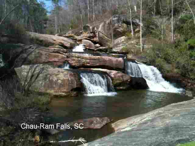
CHAU-RAM FALLS [CHAU]: Good swimming holes at falls. This is a quote from Allen Easler's South Carolina Waterfalls site - photos & info : "Chau-Ram (short for Chauga River and Ramsey Creek) is a pleasant 30-foot cascade located on Ramsey Creek in Oconee's Chau-Ram County Park just a few minutes west of Westminister. It's an easy-to-visit falls with great views for a picnic. You can also take a short hike, including a walk across a suspension bridge, to explore several rapids on the Chauga River. The park also offers an excellent campground..." PHOTO , PHOTO . Directions: From Westminister, drive west on US 76 for three miles. Turn to left into Chau-Ram County Park." Very confident. Verified by another. Updated 4/2011.
LAT, LON lat=34.68200, lon=-83.14639(source: DeLorme) (accuracy: approximate)
LINK TO GOOGLE MAP.
|
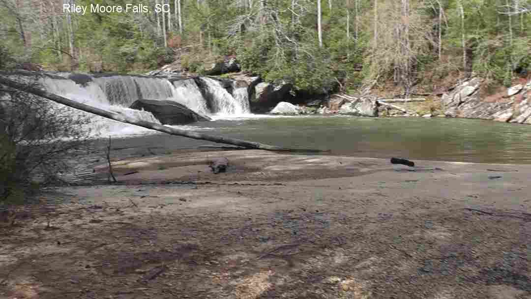
RILEY MOORE FALLS [RILE]: A primo swimming hole! Huge pool, sandy beach, gradual entry at the foot of a beautiful waterfall. PHOTO , PHOTO . Great swimming place for the whole family. An easy hike of about 1 mile each way. Camp nearby at Chau-Ram park (see above) and visit this great spot! This is a quote from Allen Easler's South Carolina Waterfalls site - photos & info : "Riley Moore Falls, at only 10 to 15 feet high, is rather short in comparison to most other falls in the mountains. Still, the facts that it occurs on the Chauga River (whitewater cousin of the Chattooga, one ridge west) and that is at least 50 feet wide make it special ..."
|
|
To get here: From Westminster, drive west on RT 76 for 7.5 miles and turn right onto Cobb Bridge Road (NOTE: This is the SECOND right turn named Cobb Bridge Road, not the first turn at the church just past Chau-Ram County Park on the left). Drive 1.5 miles on Cobb Bridge Road and turn left onto gravel Spy Rock Road (FS 748). Drive 1.7 miles to FS 748C (may be hard to spot on the right - there is the letter "C" painted on a tree - if you reach FS 748B, you have gone too far). Park on the side of the road and hike down FS 748C. (If you have a high clearance, 4WD, you can drive some distance down 748C.) Keep to the right at the fork and you will come to a metal jeep barricade. Turn left at the barricade onto a smaller trail and follow it to the river.
Very confident. Verified 2/04. Updated 2/04.
LAT, LON lat=34.74575, lon=-83.18322(source: DeLorme) (accuracy: general area)
LINK TO GOOGLE MAP.
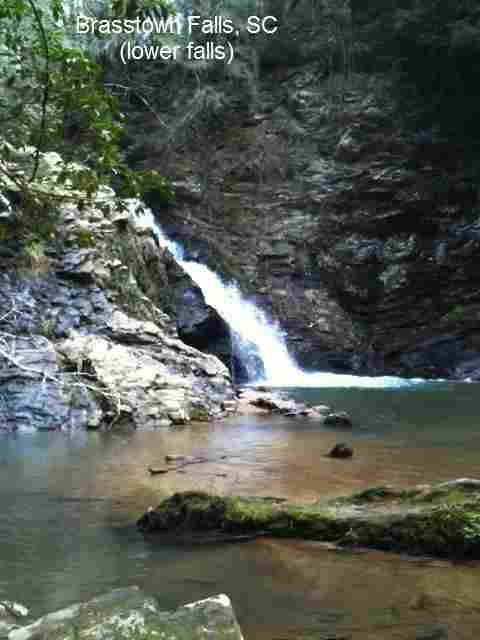
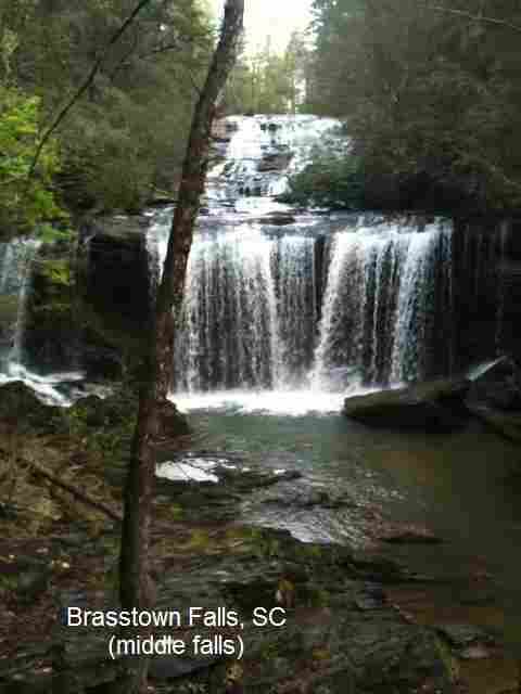
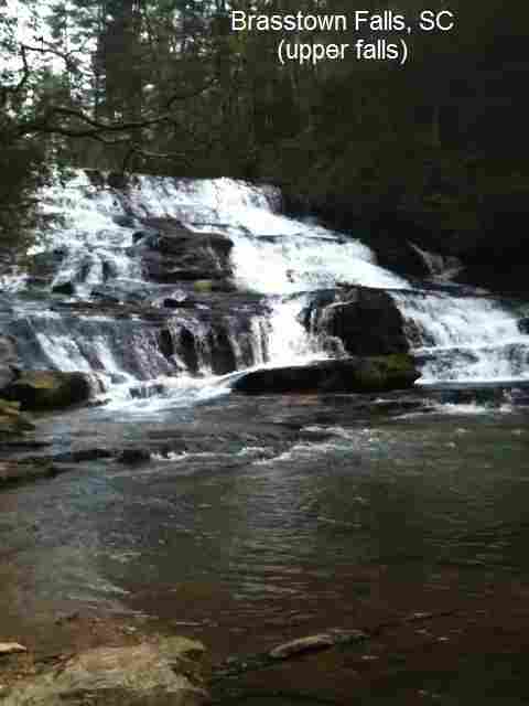
BRASSTOWN FALLS [BRAS]: Spectacular falls with 3 level falls in Brasstown Creek with multiple pools for swimming (shallow - more for wading and water play). Somewhat more difficult to get to lower levels. There is a very nice walk-in primitive camping here at the top of the falls, a short walk in from the parking area. PHOTO 1 , PHOTO 2 , PHOTO 3 .
LAT, LON lat=34.72033, lon=-83.29847(source: DeLorme) (accuracy: general area) LINK TO GOOGLE MAP
To get here: From Westminster, go northwest on RT 76 for 12 miles then turn left on Brasstown Rd./RT 48 - easy to miss, look closely for it. Drive 4.2 miles on this partially dirt road and turn right on route FS 751 just before you get to a small bridge. Drive .5 miles on FS 751 then park at the barricade. Hike on the path past the barricade along the power lines into the woods a short distance to a primitive camping area near the top of the falls. Turn right here and follow the trail downstream along side of the falls. It is a steep trail to the bottom of the falls, but it is safe and can readily be done. There are a total of four falls, but the bottom one, also known as sluice box, is treacherous to get to and swimming is not recommended here. Swim only in the upper level, calm pools at the bottom of the falls. Very confident. Verified 7/2003. Updated 7/18/2003.
IVESTOR [IVES]: Huge swimming hole in Chauga River. YOUTUBE .
LAT, LON lat=34.77257, lon=-83.2314(source: map) (accuracy: approximate) LINK TO GOOGLE MAP. To get here from RT 76 and Brasstown Rd. (above) continue another 1.5 miles on RT 76 to Academy Road (SR S 37 14). Take a right on Academy and go about 1.25 miles to Spider Valley Road (at Wildwater Adventure Center). Take right on Spider Valley and go about .75 miles to Ivestor Road. Take left on Ivestor and go about 1 mile to end of dirt road. Walk down path to Chauga River, and swimming hole is at end of path at river. Very confident. By another. Updated 9/2014.
From Westminster, follow RT 183 northeast to Walhalla, then:
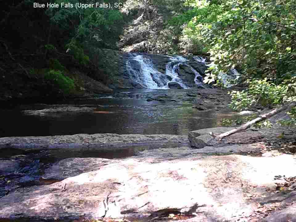
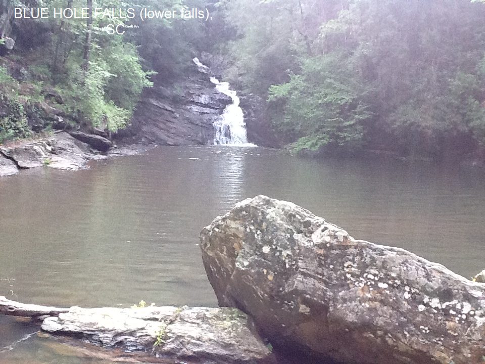
BLUE HOLE FALLS/CEDAR CREEK FALLS [BLUE]: A two level falls (upper and lower), with swimmable pools at bottom of both. The upper falls is Cedar Creek Falls, the lower is Blue Hole Falls. It is somewhat more difficult to get to the bottom of the lower falls.
LAT, LON lat=34.77119, lon=-83.18606(source: DeLorme ) (accuracy: general area) LINK TO GOOGLE MAP
To get here: In Walhalla, go west on RT 28 about 6.6 miles to (just past the Stumphouse Ranger Station) then turn left onto Whetstone Rd. (Oconee County S-37-193). Drive about .75 mi further then go left on RT 290 (Cassidy Bridge Rd.) Drive about .9 miles further and turn left onto Forest Service RT 744 - don't go as far as the Rifle Range (this is Rich Mountain Rd. but there is no sign, just a small post that says 744 vertically on it.) Drive about 3.3 miles and turn right on FR 744C (Cedar Creek Rd.) Drive about 2.5 mi to FR 2658 (where there is a barrier and earth mound that blocks access) and park. Hike .3 miles down FR 2658 to where there are 2 big rocks blocking the road to the right (paint on rocks says "Open The Trail"). Go right and hike down this road to where it ends. Then:
The upper falls or Cedar Creek Falls will be on your left. CEDAR CREEK FALLS .
To get to the pool at the bottom of the LOWER falls, which is Blue Hole Falls (more difficult), you must cross the creek right below Cedar Creek Falls (if it is shallow enough and if there is little current), then make your way downstream to the waterfall on the other side of the creek on a faint path. BLUE HOLE FALLS PHOTO , BLUE HOLE FALLS YOUTUBE VIDEO . The last part of this path is steep. You might take a rope to help get down and up this part, and do NOT try it if ground is wet.
If the creek is too deep to cross or ground is wet, come back to the trailhead, and walk up the first road to the right past the trailhead, walking around the two big rocks at the entrance to the road. Walk up that road about 100 yards, then walk down the hill to the right, which will lead to the river and then walk to the right, up to the lower falls. There is not an established path, but the hill is clear from underbrush. Pretty confident. Partially verified 7/2003. Updated 7/18/2003.
Here's a WEB SITE that has more information. Very confident. Verified 7/2003. Updated 5/2012.
EARLS FORD [CHAN]: This from a visitor:" Swimming place on the Chattooga River, which is also on the border between SC and GA. There is horse camping and trail riding on the S.C. side of the river and camping on the Georgia side of the river (but there is no bridge here). It is mostly shallow rapids that are fun to raft or tube down again and again and again. There are shallow pools along the banks that are calm and safe for young kids to splash in. On the GA side there is a rope swing hat drops into a 6 foot or so pool." LINK TO PHOTO .
"To get here from Walhalla, drive northwest on RT 28 and turn left onto Whetstone Road (Oconee County S-37-193). Drive 5 miles, and cross Chattooga Ridge Road (S-37-196) where Whetstone becomes Earls Ford Road. Continue another 4 miles to the parking area at the end of Earls Ford Road. The trailhead is at the end of the parking area.
Earls Ford Road road turns into a gravel road, but is pretty well kept. However is does get dusty going down it. There is also an outhouse facility at the trail head."
"To reach the mini-rapids and broad flat water of the scenic Chattooga River, follow this gently sloping, .3-mile, hiking-only trail. You will descend through a mixed hardwood and pine forest in the quiet, fresh mountain air. Just before the river, go left at a boulder, and you will reach the broad riverbank. Watch for deer, snakes and other wildlife. A number of small footpaths divert from the main trail, and offer other opportunities to explore this area. Be aware that this is an isolated area, so remember to bring water and first aid supplies, in addition to insect repellent. Pets are permitted." LAT, LON lat=34.8764801, lon=-83.2276558(source: map) (accuracy: approximate) LINK TO GOOGLE MAP.Pretty confident. Not verified. Updated 2/2013
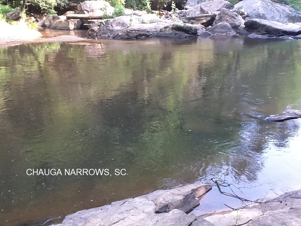
CHAUGA NARROWS [CHAN]: Really just a rapids on the Chauga River, but has a fantastic swimming area. Deep and large enough to swim laps. Also has sand and shallow entry. PHOTO , PHOTO , YOUTUBE VIDEO. Remote for bathing suit optional. To get here, from Walhalla, go west on RT 28 about 6.6 miles to (just past the Stumphouse Ranger Station) then turn left onto Whetstone Rd. (Oconee County S-37-193). Drive 3.8 miles (past turnoff for Blue Hole Falls, above)to Blackwell Bridge (this bridge crosses the Chauga River) and park beyond the bridge on left side of road. Hike 0.6 mile downstream to the falls on a faint path that parallels the river. Can drive part way with four-wheel drive vehicle.
(Caution: At approximately 0.5 mile the river curves right and the dirt path becomes rock. The wet areas of these rocks can be very slippery.) LAT, LON lat=34.8271, lon=-83.1727(source: web site) (accuracy: approximate) LINK TO GOOGLE MAP.Pretty confident. Verified by another. Updated 5/2012
GRAPEVINE [GRAP]: Huge swimming hole on Chauga River. (Not sure of the local name for this, we call it Grapevine.) YOUTUBE . Remote for bathing suit optional. To get here, continue north on Whetstone Rd. (cross Chauga River on Blackwell Bridge) and, about 1 mile past the bridge, turn west (left) on Chattooga Ridge Rd (SR S-37-196) Go about 1.5 miles on Chattooga Ridge Rd and take left on Grapevine Branch Road (FS 764). Go to end of dirt road at Grapevine campground (no facilities, no fee). Go right into campground to next to last campsite on left. Swimming hole is in Chauga River. LAT, LON lat=34.82578, lon=-83.19135(source: map) (accuracy: approximate) LINK TO GOOGLE MAP.Pretty confident. Verified by another. Updated 9/2014
LICKLOG FALLS/PIGPEN FALLS [LICK]: Two waterfalls on Licklog Creek with pools below. About a 30-minute hike on a section of the Chattooga Trail. To get here: From Walhalla , drive northwest on S.C. 28 for 8.4 miles (past turnoff for Blue Hole Falls and Chauga Narrows, above), and bear right onto RT 107. Go about 5 miles on RT 107 (past the entrance to Oconee State Park) and turn left onto Village Creek Road. Go 1.7 miles on Village Creek Road and turn right onto Nicholson Ford Road (gravel). Go about 2 miles to a parking area on the right. Park and access the Foothills Trail in a corner of the parking lot.
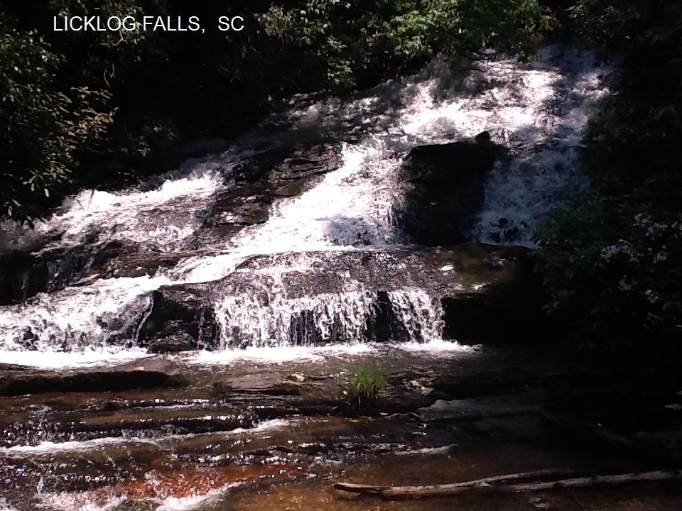
Hike west on the Foothills Trail (follow white blazes) for .5 mile and turn left onto the Chattooga Trail (black blazes). Go .2 miles to Pigpen Falls, which has a small pool at the bottom. To continue on to Licklog, cross the footbridge and go .2 miles on the Chattooga Trail. The first level of Licklog Falls is on the right side of the trail. Licklog has a large pool with a sandy area. LICKLOG PHOTO , YOUTUBE VIDEO. LAT, LON lat=34.92883, lon=-83.12975(source: DeLorme ) (accuracy: general area) LINK TO GOOGLE MAP.Pretty confident. Not verified. Updated 3/18/2007
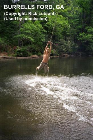
BURRELL FORD [BURR]: Several swimming places in the Chattooga River in the Burrell Ford area, one near a bridge and another at the Burrell Ford Campground.
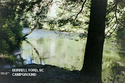
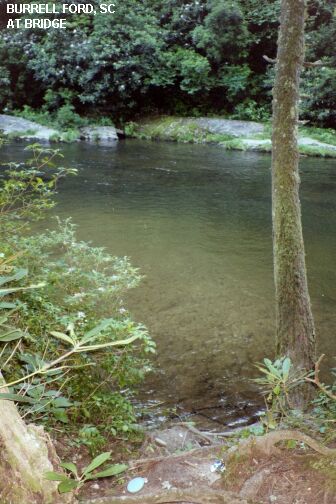
YOUTUBE . To get here: Continue northeast on RT 107 from the Licklog Falls turnoff (above), past the Cherry Hill Campground and turn left on Burrell Ford Rd. (well signed). Drive down this road to the Burrell Ford Campground and park (this is a walk in campground, about a .25 mile walk). Walk down to the campground which is on the Chattooga River - there are swimming places here. PHOTO AT CAMPGROUND. To get to the other swimming place, continue down Burrell Ford Rd. a short distance and cross the bridge over the Chattooga river. PHOTO 1 AT BRIDGE , PHOTO 2 AT BRIDGE . Park on the left and walk to the river. The swimming place is here. Very confident. Verified 7/2003. Updated 7/18/2003.LAT, LON lat=34.973, lon=-83.114(source: measured ) (accuracy: approximate)
LINK TO GOOGLE MAP.
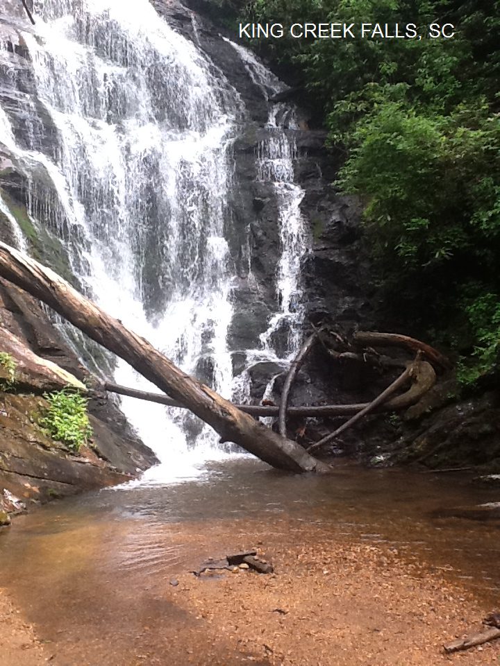
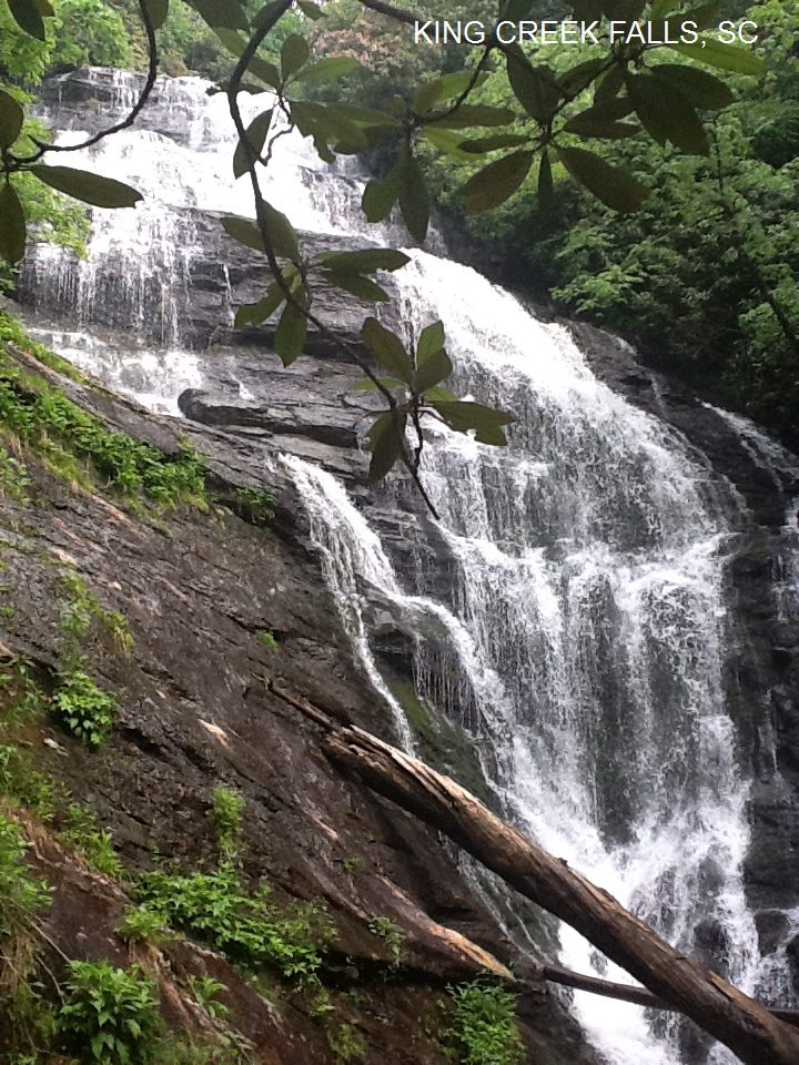
KING CREEK FALLS [KING]: Beautiful falls with water play/wading place at bottom. A short hike from Burrell Ford campground (above). PHOTO , PHOTO , YOUTUBE VIDEO Not deep enough to swim, but good for wading. To get here from the parking area for Burrell Ford campground (above) park in the area on the left at Burrells Ford Campground sign. Hike the Chattooga Trail/ road (gravel) that begins at the southern end of the parking lot. Follow it 0.3 mile, past the last campsite on the right side of the trail and just north of King Creek. Take the first left (east) by the north bank of the creek. Proceed 250 yards and cross over the creek on a bridge.
Turn left (east) onto the trail to the falls. Climb the wooden steps and continue to the falls. The wading place is here. Very confident. Verified by another. Updated 5/2012.LAT, LON lat=34.96608, lon=-83.11011(source: map) (accuracy: approximate)
LINK TO GOOGLE MAP.
|
|---|
|
CONFIDENCE | Very confident |
|---|
|
VERIFIED | Mostly, 7/2003. |
|---|
|
DATE UPDATED | 5/2012 |
|---|
|
|---|
This swimming hole listing is by
www.swimmingholes.org
TODD CREEK FALLS
(TODD)
|
|
TOWNS | CLEMSON, SIX MILE |
|---|
| LAT, LON | lat=34.754, lon=-82.8154(source:measured) (accuracy:approximate)
LINK TO GOOGLE MAP |
|---|
|
STATE | SC |
|---|
|
WATER | Todd Creek |
|---|
|
TYPE | Falls |
|---|
|
DESCRIPTION | Short hike to Todd Creek Falls - a nice falls and pool at the bottom, though sometimes a little muddy. Pool is deep and has some gradual entry points on the sides. |
|---|
|
AREAS | Unknown |
|---|
|
SANCTION | Unofficial |
|---|
|
FEE | None |
|---|
|
FACILITIES |
None |
|---|
|
ACTIVITIES |
Swimming |
|---|
|
PHONE | none |
|---|
|
CAMPING | Army Engineers campgrounds south of here on Hartwell Lake. |
|---|
|
BATHING SUITS | Optional |
|---|
|
DIRECTIONS | From Six Mile (north of Clemson), take SC 133 south for .5 mile to Maw Bridge Road. Turn left and drive 2.8 miles to Welcome Baptist Church. Take the next road to your right (Brookbend Road) and follow for .4 mile to the bottom of the hill where there is a bridge over Todd Creek. Look for the three sets of high voltage power lines overhead to be sure you are at the right spot. Find a place to park along the side of the road by the bridge. On the far side of the bridge, under the power lines, look for a trail/road on your left. Walk this trail about 5 minutes then keep left where it goes down to the creek. Wade across the creek then continue downstream another .1 mile and take a steep path down to the falls.
|
|---|
|
CONFIDENCE | Very confident |
|---|
|
VERIFIED | Yes, 5/2014 |
|---|
|
DATE UPDATED | 5/2014 |
|---|
|
|---|
HOME
|