See a SLIDESHOW of swimming hole photos in this state.
This swimming hole listing is by
www.swimmingholes.org
ALVORD HOT SPRINGS
(ALVO)
|
|
|---|
|
TOWNS | WINNEMUCCA (NV), BURNS JUNCTION (OR), FRENCHGLEN (OR) |
|---|
| LAT, LON | lat=42.544, lon=-118.533(source: web site) (accuracy:approximate)
LINK TO GOOGLE MAP |
|---|
|
STATE | OR |
|---|
|
WATER | Alvord Hot Springs |
|---|
|
TYPE | Hot Springs |
|---|
|
DESCRIPTION | Natural hot water led into pools and closures. Is on private property, now has fee to use and caretaker (store being developed). Great view of Steens Mountains. (See also Whitehorse Hot Springs nearby) WEB INFO , NEWS ARTICLE
|
|---|
|
AREA | Alvord Ranch |
|---|
|
SANCTION | Official |
|---|
|
FEE | Yes, in 2013 - $5 per person for 24 hours access |
|---|
|
FACILITIES |
Toilet, store |
|---|
|
ACTIVITIES |
Hot Tubbing |
|---|
|
PHONE | None |
|---|
|
CAMPING | None at site. |
|---|
|
BATHING SUITS | Optional (very) |
|---|
|
DIRECTIONS | From Frenchglen (way out in the desert in SE Oregon, just west of the Steens Mountains) take RT 205 south about 50 miles then turn north (left) on the Fields-Denio Rd.. Go about 25 miles on this road to the coordinates given here. The hot springs is here. Buildings and a parking area should be visible from the road. |
|---|
|
CONFIDENCE | Very confident |
|---|
|
VERIFIED | No |
|---|
|
DATE UPDATED | 2/2014 |
|---|
This swimming hole listing is by
www.swimmingholes.org
APPLEGATE AREA
[3 PLACES]
(APPA)
|
|
|---|
|
TOWNS | MEDFORD, JACKSONVILLE, RUCH |
|---|
|
STATE | OR |
|---|
|
WATER | Varies-see below |
|---|
|
TYPE | River/Lake |
|---|
|
DESCRIPTION | Swimming places in the Applegate River area southwest of Medford. See DIRECTIONS below for details. |
|---|
|
AREA | Varies-see below |
|---|
|
SANCTION | Unofficial |
|---|
|
FEE | Varies-see below |
|---|
|
FACILITIES |
Varies-see below |
|---|
|
ACTIVITIES |
Swimming |
|---|
|
PHONE | Unknown |
|---|
|
CAMPING | Camping at all 3 swimming locations below. |
|---|
|
BATHING SUITS | Customary |
|---|
|
DIRECTIONS | From Medford on I-5, take exit 30 then RT 62 south a short way then continue onto RT 238 southwest through Jacksonville, then:
APPLEGATE LAKE [APPL]: Large, clean lake with many secluded coves to swim and a large, designated swim beach as well. The designated area (day use fee, also a campground) is the Hart-Tish Recreation Area . A much more secluded place to swim is where Manzanita Creek enters the lake. See directions below.
LAT, LON (at Hart-Tish) lat=42.05280, lon=-123.1286(source: map) (accuracy:approximate) LINK TO GOOGLE MAP.
LAT, LON (at Manzanita) lat=42.02048, lon=,-123.14970(source: map) (accuracy:approximate) LINK TO GOOGLE MAP.
To get to Hart-Tish from RT 238 at Jacksonville (above) go 6.5 miles west on RT 238 (Medford-Provolt Hwy) to Ruch then turn left on to Upper Applegate Road (County Road 859). Continue 16 miles to Hart-tish park.
To get to Manzanita Creek from Hart-Tish, continue on Applegate Rd. along the reservoir to the T intersection and turn left to continue on Applegate Rd. In about 1 mile, turn left again on Manzanita Creek Rd. and continue until this road comes to the mouth of Manzanita Creek where it enters the lake. Pretty confident. Not verified. Updated 10/2014.
CANTRALL-BUCKLEY COUNTY PARK [CANT]: With 2 miles of frontage on the Applegate River, this park offers camping, tubing and all facilities. Small day use fee. Bathrooms and picnic tables. Unofficial swimming, no lifeguards. WEB SITE . For a short tubing trip (about 20 mins), begin at a small bridge over Cantrall Rd. and tube down to a bend in the river. LAT, LON lat=42.22108, lon=-123.0663(source: map) (accuracy:approximate) LINK TO GOOGLE MAP. To get here from RT 238 at Jacksonville (above) go 8 miles west on RT 238 (Medford-Provolt Hwy) , turn left on Hamilton Rd. then turn right on Cantrall Rd.. Pretty confident. Not verified. Updated 10/2014.
SQUAW LAKES [SQUA]: About 9 miles east of Applegate Lake are a pair of pristine lakes, Big Squaw Lake and Little Squaw Lake. The is a developed campground here but it appears to take a hike from the campground to get to swimming places on either lake. Unknown length of hike. No designated swimming area. LAT, LON (drive to) lat=42.03645, lon=-123.02074(source: map) (accuracy:approximate) LINK TO GOOGLE MAP.
To get here from Applegate Rd. (RT 238), at the north end of Applegate Lake (BEFORE you get to Hart-Tish), turn east (left) onto French Gulch Rd., which crosses the dam, and go about 1.5 miles. Turn south (right) on NF 1075. Go about 8 miles, zigging and zagging, on NF 1075 which becomes French Gulch Rd. again and becomes NF 490 before it comes to the Squaw Lakes. There is a developed NF campground here (accepts reservations). Hike into the lakes, don�t know specifically where the best swimming places are on the lakes or how long the hikes are. Pretty confident. Not verified. Updated 10/2014.
|
|---|
|
CONFIDENCE | Pretty confident |
|---|
|
VERIFIED | No |
|---|
|
DATE UPDATED | 10/2014 |
|---|
This swimming hole listing is by
www.swimmingholes.org
BAGBY AREA
[3 PLACES]
(BAGA)
|
|
|---|
|
TOWNS | PORTLAND, ESTACADA |
|---|
|
STATE | OR |
|---|
|
WATER | BAGBY AREA |
|---|
|
TYPE | Hot Springs/ Swimming Hole |
|---|
|
DESCRIPTION | Swimming hole in the Clackamas River plus a famous (natural) hot springs, both along the Clackamas Hwy southeast of Portland. For details, see DIRECTIONS below.
|
|---|
|
AREA | Mount Hood National Forest |
|---|
|
SANCTION | Unofficial |
|---|
|
FEE | Forest pass required |
|---|
|
FACILITIES |
None |
|---|
|
ACTIVITIES |
Swimming/Hot tubbing |
|---|
|
PHONE | None |
|---|
|
CAMPING | Numerous N.F. campgrounds along the hwy. |
|---|
|
BATHING SUITS | Optional |
|---|
|
DIRECTIONS |
From Portland, take RT 224 (Clackamas Hwy) to Estacada then (set odometer):
BUCK LAKE [BUCK]: A short (.5 mile, one way) hike to a pristine lake with blue-green clear water. Bathing suits optional. LAT, LON (Trailhead - these coordinates in your auto gps should take you right to the trailhead) lat=45.11354, lon=-121.86327(source: map) (accuracy: approximate) LINK TO GOOGLE MAP. To get here from Estacada, drive 26 miles on RT 224 to the Ripplebrook area, then turn left onto NF-4631 and go about 2.4 miles then turn right onto NF-4630 and go about .6 miles. Take the 1st right to stay on NF-4630 and go 4 miles then a slight left onto NF-57/Oak Grove Fork Rd and go 1.1 miles then take the 1st left onto NF-58 and go another 1.1 miles and turn right onto NF-5810. Continue on NF 5810 about 5 miles then bear left onto NF-210. Drive about .5 miles on FR 210 and see on the left a parking area and a trailhead that is unmarked. Hike .5 miles to the lake and swimming hole. Not Verified. Pretty confident. Updated 11/2012
ALDER FLAT [ALDE]: A short (.9 mile, one way) easy hike to the Alder Flat campground (no facilities) and the very idyllic Alder Flat swimming hole right at the campground. This is in the upper Clackamas River and is cold all summer and has a current as well, so be careful. Camping at site (no water or toilets). Bathing suits optional. LAT, LON lat=45.0841, lon=-122.061(source: map) (accuracy: approximate) LINK TO GOOGLE MAP. To get here from Estacada, drive 26 miles on RT 224 to (just before reaching the Ripplebrook Ranger Station), on the right side, you will see the Alder Flats Trail head #574. Hike the easy .9 miles to the campground and swimming hole. Not Verified. Very confident. Updated 11/2012.
BAGBY HOT SPRINGS [BAGB]: 1.5 mile one-way scenic hike to a very well known hot springs. LINK TO PHOTOS. Natural hot water is led in to a series of volunteer-built tubs of various sizes, some with shelters above. Nudity is common. PLEASE, RESPECT THIS UNIQUE, BEAUTIFUL SERENE PLACE. Bathing suits optional. LAT, LON lat=44.9356776, lon=-122.1736904 (source: map) (accuracy: approximate) LINK TO GOOGLE MAP. To get here from Estacada on RT 224,go 0.5 miles past the Ripplebrook Guard Station then turn right on FR 46. Go another 3.5 miles then keep right onto FR 63. In another 3.5 miles turn right on FR 70. Drive six miles to the trailhead parking lot on the left. Northwest Forest Pass required. Park and hike the trail to Bagby (trail number 544) for 1.5 miles to the springs. The trail is well-maintained and easy. Verified. Very confident. Updated 11/2012.
|
|---|
|
CONFIDENCE | Very confident |
|---|
|
VERIFIED | See above |
|---|
|
DATE UPDATED | 11/2012 |
|---|
This swimming hole listing is by
www.swimmingholes.org
CANTON CREEK AREA
[4 PLACES]
(CANA)
|
|
|---|
|
TOWNS | ROSEBURG, GLIDE |
|---|
|
STATE | OR |
|---|
|
WATER | North Umpqua River |
|---|
|
TYPE | River/Falls |
|---|
|
DESCRIPTION |
Swimming holes east of Glide on RT 138, the North Umpqua Hwy. Several very close together, often no signs, go slowly! For details, see DIRECTIONS below. BEWARE OF POISON OAK! |
|---|
|
AREA | None |
|---|
|
SANCTION | Unofficial |
|---|
|
FEE | None |
|---|
|
FACILITIES |
Picnic Tables, Toilets |
|---|
|
ACTIVITIES |
Swimming |
|---|
|
PHONE | none |
|---|
|
CAMPING | Developed camping at Whistlers Bend and Cavitt Creek Falls. |
|---|
|
BATHING SUITS | Customary |
|---|
|
DIRECTIONS |
From Susan Creek Campground on RT 138 (see "North Umpqua Area" below) continue east on RT 138 and, between mileposts 38 and 39, turn left on FR 38 (Steamboat Creek Rd.). Then:
CANTON CREEK CAMPGROUND [CANC]: Swimming places just above and below the junction of Canton Creek and Steamboat Creek. Very easy access, short walk along creek. PHOTO , PHOTO , PHOTO . From junction of RT 138 and FR 38 (above) go about .4 mile on Steamboat Creek Rd. where you will see signs for the Canton Creek Campground. Drive into the campground and to the left until you come to a dead-end parking area alongside the creek. Park and walk the path upstream to where Canton Creek and Steamboat Creek come together. Very nice swimming places both upstream and downstream of this junction. LAT, LON lat=43.3484, lon=-122.7296 (source: measured) (accuracy:approximate) LINK TO GOOGLE MAP. Verified 8/13. Very confident. Updated 8/2013.
LITTLE FALLS [LITF]: In no way little and our photo doesn't do it justice at all. Huge, deep pool at bottom of a multi-chute waterfalls. Jumping from many levels. Popular place. Great swimming hole! PHOTO . From Canton Creek Campground (above) continue about 1 mile further on Steamboat Creek Rd to a dirt turnout on the right - the falls are visible from the road. LAT, LON lat=43.3561, lon=-122.7189 (source: measured) (accuracy:approximate) LINK TO GOOGLE MAP. Verified 8/13. Very confident. Updated 8/2013.
CANTON CREEK FALLS [CANF]: Low falls into big pool with lots of rocks around for relaxing. Both shallow and deep places. PHOTO , PHOTO . Near the Canton Creek Campground, turn left on Canton Creek Rd.. Go about 1.5 miles to a turnout on the left. You can see Canton Creek Falls from the road. LAT, LON lat=43.37012, lon=-122.7455 (source: measured) (accuracy:approximate) LINK TO GOOGLE MAP. Verified 8/13. Very confident. Updated 8/2013.
SCAREDMAN [SCAR]: Big pools with sand and lots of rocks around for relaxing. Both shallow and deep places. Great swimming hole! Campground at the site. PHOTO . From Canton Creek Falls (above) continue about 2 miles further on Canton Creek Rd. to the signs for Scaredman Campground. Pass the campground turn off and park just past the bridge. The swimming hole is upstream of the bridge. LAT, LON lat=43.38, lon=-122.767 (source: measured) (accuracy:approximate) LINK TO GOOGLE MAP. Verified 8/13. Very confident. Updated 8/2013.
|
CONFIDENCE | Very confident |
|---|
|
VERIFIED | Yes |
|---|
|
DATE UPDATED | 8/2013 |
|---|
|
|---|
This swimming hole listing is by
www.swimmingholes.org
COQUILLE-MYRTLE GROVE S. P.
(COQU)
|
|
|---|
|
TOWNS | ROSEBURG, COOS BAY, MYRTLE POINT |
|---|
| LAT, LON | lat=42.955555, lon=-124.10555(source: DeLorme) (accuracy:approximate)
LINK TO GOOGLE MAP |
|---|
|
STATE | OR |
|---|
|
WATER | Coquille River |
|---|
|
TYPE | River |
|---|
|
DESCRIPTION |
Swimming place near coast of Oregon at state picnic area in bend of
Coquille River. Secluded swimming hole has a shaded myrtlewood grove
near the parking area and a sandy beach along the Coquille River just a
short way down the hill. Bring your inner tube and float along with the
river's gentle current. No drinking water at site. |
|---|
|
AREA | Coquille-Myrtle Grove S. P. |
|---|
|
SANCTION | Official |
|---|
|
FEE | None |
|---|
|
FACILITIES |
Picnic Tables, Toilets |
|---|
|
ACTIVITIES |
Swimming |
|---|
|
PHONE | 1-800-551-6949 |
|---|
|
CAMPING | No camping at site. There are several campgrounds nearby on the coast. |
|---|
|
BATHING SUITS | Customary |
|---|
|
DIRECTIONS |
From Roseburg, go south a short way on I-5 to Exit 120 then west on RT
42. Near Myrtle Point, go south on Powers Highway about 10 miles to the
state park. Easy walk down to river swimming place. |
|---|
|
CONFIDENCE | Very confident |
|---|
|
VERIFIED | No |
|---|
|
DATE UPDATED | 1/10/2003 |
|---|
This swimming hole listing is by
www.swimmingholes.org
CORVALLIS AREA
[2 PLACES]
(CORA)
|
|
|---|
|
TOWNS | CORVALLIS, ALPINE, PHILOMATH, JUNCTION CITY |
|---|
|
STATE | OR |
|---|
|
WATER | Varies - see below |
|---|
|
TYPE | Varies - see below |
|---|
|
DESCRIPTION | Swimming holes south and west of Corvallis. See directions below for details. |
|
|---|
|
AREA | Varies - see below |
|---|
|
SANCTION | Varies - see below |
|---|
|
FEE | No |
|---|
|
FACILITIES |
Varies - see below |
|---|
|
ACTIVITIES |
Swimming |
|---|
|
PHONE | Unknown |
|---|
|
CAMPING | Varies - see below |
|---|
|
BATHING SUITS | Varies - see below |
|---|
|
DIRECTIONS | All directions are from Corvallis:
PHILOMATH [PHIL]: Local town swimming hole in Mary�s River. Situated on a bend in the Mary�s River. Good shallow area for kids. There is a small beach. No camping at site. Bathing suits required. LAT, LON lat=44.53482, lon=-123.3741(source: map) (accuracy:approximate) LINK TO GOOGLE MAP. To get here from Corvallis, take RT 20/34 (SW Philomath Blvd.) west to Philomath. In Philomath, take 9th St. south to the end of the street. Park in the field. Take the trail to the river. Not Verified. Pretty confident. Updated 3/2011.
ALSEA FALLS [ALSF]: Beautiful cascade-type falls in Alsea River with pool to swim in at bottom. This is a BLM
recreation area with camping, picnicking and toilets. No fee to go to falls. Camping at the site. Bathing suits unknown. LAT, LON lat=44.32958, lon=-123.49986(source: map) (accuracy:exact) LINK TO GOOGLE MAP. To get here from Corvallis, take RT 20/34 (SW Philomath Blvd.) west through Philomath (see above) then continue on RT 20/34 (now the Alsea Hwy) about 20 miles to Alsea. In Alsea, take S 2nd St. south (becomes Alsea-Deadwood Hwy) for about 1 mile then turn left at S Fork Rd. Follow S Fork Rd. as it winds along for about 8 miles to the Alsea Falls Recreation Area. Not Verified. Pretty confident. Updated 3/2011.
|
|---|
|
CONFIDENCE | Pretty confident |
|---|
|
VERIFIED | No |
|---|
|
DATE UPDATED | 3/2011 |
|---|
This swimming hole listing is by
www.swimmingholes.org
CRATER LAKE N. P. AREA
[2 PLACES]
(CRAT)
|
|
|---|
|
TOWNS | ROSEBURG, GRANTS PASS |
|---|
|
STATE | OR |
|---|
|
WATER | Crater Lake |
|---|
|
TYPE | Lake |
|---|
|
DESCRIPTION | There are not many places you can access Crater Lake for swimming and there are not many people who will go into the very cold, very deep water, but if you are one of them continue. CRATER LAKE N. P. WEB SITE. See DIRECTIONS below for details. |
|---|
|
AREA | Crater Lake N. P. |
|---|
|
SANCTION | Unofficial |
|---|
|
FEE | Unknown |
|---|
|
FACILITIES |
All facilities at the lodge area. |
|---|
|
ACTIVITIES |
Swimming, jumping |
|---|
|
PHONE | none |
|---|
|
CAMPING | Developed camping at the lodge area. (Fierce mosquitoes in summer) |
|---|
|
BATHING SUITS | Unknown |
|---|
|
DIRECTIONS | Go to Crater Lake N. P., then
CLEETWOOD COVE [CLEE]: It is a strenuous hike of 1.1 miles each way (steep elevation change) to the place where you can jump and swim in Crater Lake. Very cold, very deep water. YOUTUBE , YOUTUBE . LAT, LON (drive to) lat=42.98007, Lon=-122.07407(source: map) (accuracy:approximate) LINK TO GOOGLE MAP. LAT, LON (hike to) lat=42.97624, Lon=-122.08896(source: map) (accuracy:approximate) LINK TO GOOGLE MAP To get here in Crater Lake N. P., take the Rim Rd. to the north side of the lake (coordinates above) to the trailhead for Cleetwood Cove Trail. Take the strenuous 1.1 mile (each way) hike down the trail to a rock outcropping above the lake. Pretty confident. Not Verified. Updated 2/2013.
WIZARD ISLAND [WIZA]: You can swim also on the western side of Wizard Island.
YOUTUBE . Take the boat tour - you must choose to stay either 3 or 6 hours on the island. Take your bathing suit and hiking/swimming shoes. It is a 1.1 mile hike down to get to the boat then a hike of unknown length once you are on the island to get to the place where you can jump and swim in Crater Lake. Very cold, very deep water. LAT, LON (drive to) lat=42.90401, Lon=-122.14067(source: map) (accuracy:approximate) LINK TO GOOGLE MAP. LAT, LON (boat/hike to) lat=42.93915, Lon=-122.14840(source: map) (accuracy:general area) LINK TO GOOGLE MAP To get here in Crater Lake N. P., go to the visitor center and get tickets for the boat tour then follow their directions. Pretty confident. Not Verified. Updated 2/2013.
|
|---|
|
CONFIDENCE | Pretty confident |
|---|
|
VERIFIED | No |
|---|
|
DATE UPDATED | 2/2013 |
|---|
This swimming hole listing is by
www.swimmingholes.org
CROSS PARK - HIGH ROCKS
(CROSS)
|
|
|---|
|
TOWNS | PORTLAND, OREGON CITY, GLADSTONE |
|---|
| LAT, LON | lat=45.37900
, lon=-122.5869 (source: map) (accuracy:approximate)
LINK TO GOOGLE MAP |
|---|
|
STATE | OR |
|---|
|
WATER | Clackamas River |
|---|
|
TYPE | River |
|---|
|
DESCRIPTION | Swimming places near Portland on the cold, clear, clean Clackamas River. One is more of a family place, called "Cross Park", the other a rowdy youth scene with jumping and frequent alcohol-related accidents, called "High Rocks". High Rocks may have lifeguards during peak times, not sure. They are within easy walking of each other. This water is always VERY COLD, even in late summer. |
|---|
|
AREA | Cross Park - High Rocks Park |
|---|
|
SANCTION | Unofficial |
|---|
|
FEE | Unknown |
|---|
|
FACILITIES |
Unknown |
|---|
|
ACTIVITIES |
Swimming, Jumping |
|---|
|
PHONE | Unknown |
|---|
|
CAMPING | No camping at site |
|---|
|
BATHING SUITS | Unknown |
|---|
|
DIRECTIONS | BUS: Take the 33 bus from downtown Portland to Gladstone and walk to the river. AUTO: From Portland, take I-205 south to the Gladstone Exit 11. Continue south on Southeast 82nd Ave., take a right on Columbia Ave., a left on 1st Street, and left on Yale Avenue. Park legally and walk downstream to Cross Park or upstream to High Rocks. Cross Park is just downstream of the old (closed) truss bridge. High Rocks is upstream of this old bridge. |
|---|
|
CONFIDENCE | Very confident |
|---|
|
VERIFIED | Yes |
|---|
|
DATE UPDATED | 10/2014 |
|---|
This swimming hole listing is by
www.swimmingholes.org
DOVRE
(DOVR)
|
|
|---|
|
TOWNS | SALEM, MCMINNVILLE |
|---|
| LAT, LON | lat=45.316
, lon=-123.477 (source: Web Site) (accuracy:exact)
LINK TO GOOGLE MAP |
|---|
|
STATE | OR |
|---|
|
WATER | Nestucca River |
|---|
|
TYPE | River |
|---|
|
DESCRIPTION |
Nestucca River swimming hole at BLM. |
|---|
|
AREA | Tillamook State Forest |
|---|
|
SANCTION | Unofficial |
|---|
|
FEE | Unknown |
|---|
|
FACILITIES |
Picnic tables and toilets |
|---|
|
ACTIVITIES |
Swimming |
|---|
|
PHONE | Unknown |
|---|
|
CAMPING | Camping at site |
|---|
|
BATHING SUITS | Unknown |
|---|
|
DIRECTIONS | From McMinnville, go about 5 miles north on RT 47. In Carlton, turn west (left) on NW Meadow Lake Road and continue onto the Nestucca River Access Road, all told about 15 miles from Carlton |
|---|
|
CONFIDENCE | Pretty confident |
|---|
|
VERIFIED | No |
|---|
|
DATE UPDATED | 5/14/2009 |
|---|
This swimming hole listing is by
www.swimmingholes.org
FALL CREEK AREA
[5 PLACES]
(FALA)
|
|
|---|
|
TOWNS | EUGENE, DEXTER, LOWELL |
|---|
|
STATE | OR |
|---|
|
WATER | Fall Creek |
|---|
|
TYPE | Creek swimming holes |
|---|
|
DESCRIPTION | Southeast of Eugene on Fall Creek are some outstanding swimming holes. For details, see DIRECTIONS below. |
|---|
|
AREA | Willamette N. F. |
|---|
|
SANCTION | Unofficial |
|---|
|
FEE | None |
|---|
|
FACILITIES |
Varies - see below |
|---|
|
ACTIVITIES |
Swimming |
|---|
|
PHONE | Unknown |
|---|
|
CAMPING | There are numerous N. F. camping areas near here |
|---|
|
BATHING SUITS | May be optional in some places (some are pretty remote) |
|---|
|
DIRECTIONS |
From Eugene, take I-5 south then take Exit 188A to RT 58 south/east. Go about 13 miles on RT 58 then turn north
(left) on the Jasper-Lowell Rd.. Go about 3 miles (through the town of Lowell) and turn east (right) on Big Fall Creek Rd.. [RESET ODOMETER HERE.] Then:
DOLLY VARDEN [DOLL]: Wide, deep swimming hole with sandy beach and some current - rapids downstream. Camping at site. PHOTO , YOUTUBE . To get here: Go about 10 miles from the turn onto on Big Fall Creek Rd to the sign for Dolly Varden campground. Park on the right before the bridge. The swimming hole is here. LAT, LON : lat=43.9636, lon=-122.6191(source: Measured) (accuracy:approximate) LINK TO GOOGLE MAP. Very confident. Verified 8/2013. Updated 8/2013.
BROKEN BOWL [BROK]:
Continue east from Dolly Varden a short way on Big Fall Creek Rd. and you will come to signs for the Broken Bowl Campground. The swimming hole is behind site #13. PHOTO . LAT, LON : lat=43.962, lon=-122.609(source: measured) (accuracy:approximate) LINK TO GOOGLE MAP. Very confident. Verified 8/2013. Updated 8/2013.
BIG POOL [BIGP]: Swimming hole with very clear water and moderate current. Camping nearby at Big Pool campground. PHOTO . To get here continue east from Broken Bowl about 1 mile to signs for Big Pool Campground. GO PAST the campground entrance and park at a small wide spot on the right. Walk to creek. LAT, LON : lat=43.9676, lon=-122.5941(source: Measured) (accuracy:approximate) LINK TO GOOGLE MAP. Very confident. Verified 8/2013. Updated 8/2013.
CLARK CREEK [CLAR]: Swimming hole with group campsite nearby. PHOTO , PHOTO , PHOTO . To get here continue east from Broken Bowl about 2 miles to the sign for Clark Creek Group Camp and park between mileposts 12 and 13. Cross the road and walk to the swimming hole. , LON : lat=43.9728, lon=-122.5755 (source: Measured) (accuracy:approximate) LINK TO GOOGLE MAP. Very confident. Verified 8/2013. Updated 8/2013.
BEDROCK [BEDR]: A large, 6 foot-deep swimming hole by a N.F. campground. PHOTO , PHOTO . To get here go about 2 miles from Clark Creek and look for the signs for the Bedrock Campground. The entrance to the campground goes over a bridge over the creek and the swimming hole is under this bridge. There are lots of "no parking" signs along here - it is not clear if there is anyplace to park and swim unless you are camping in the campground. LAT, LON : lat=43.9715, lon=-122.5455(source: Measured) (accuracy:approximate) LINK TO GOOGLE MAP. Very confident. Verified 8/2013. Updated 8/2013.
|
|---|
|
CONFIDENCE | See above |
|---|
|
VERIFIED | See above |
|---|
|
DATE UPDATED | 8/2013 |
|---|
This swimming hole listing is by
www.swimmingholes.org
FALLS CITY FALLS
(FALL)
|
|
|---|
|
TOWNS | SALEM, DALLAS, FALLS CITY |
|---|
| LAT, LON (of falls) | lat=44.86278, lon=-123.55083(source: map) (accuracy: approximate)
LINK TO GOOGLE MAP |
|---|
|
STATE | OR |
|---|
|
WATER | Little Luckiamute River |
|---|
|
TYPE | River/Falls |
|---|
|
DESCRIPTION | Traditional swimming places in the Little Luckiamute River and the Little Luckiamute Falls in the region of Falls City. It is not clear just what public access is currently available - there is a group working to protect public access to this river and falls. Ask locally about current status. The Falls City town web site mentions swimming in the river. There may be a hike to the falls. |
|---|
|
AREA | State Experimental Forest |
|---|
|
SANCTION | Unknown |
|---|
|
FEE | None |
|---|
|
FACILITIES |
none |
|---|
|
ACTIVITIES |
Swimming, Jumping |
|---|
|
PHONE | none |
|---|
|
CAMPING | None at site. |
|---|
|
BATHING SUITS | Customary |
|---|
|
DIRECTIONS | From Salem, take RT 22 west then RT 223 west to Dallas. In Dallas, turn west (right) off RT 223 onto Oakdale Rd and stay on it to Falls City. Ask locally about swimming in the Little Luckiamute River and/or at Little Luckiamute Falls (the falls are west of Falls City generally by way of Black Rock Rd.. There may be a hike to the falls.) No better directions. |
|---|
|
CONFIDENCE | Uncertain |
|---|
|
VERIFIED | No |
|---|
|
DATE UPDATED | 2/2014 |
|---|
This swimming hole listing is by
www.swimmingholes.org
FLORA DELL FALLS
(FLOR)
|
|
|---|
|
TOWNS | GRANTS PASS, GOLD BEACH, AGNESS |
|---|
| LAT, LON (Trailhead at Foster Bar) | lat=42.63462, lon=-124.0520(source: map) (accuracy: approximate)
LINK TO GOOGLE MAP |
|---|
|
STATE | OR |
|---|
|
WATER | Flora Dell Creek (at Rogue River) |
|---|
|
TYPE | Falls |
|---|
|
DESCRIPTION | Swimming place at foot of 30 foot falls popular with Rogue River runners and Rogue River Trail Hikers. This is usually visited as part of a longer hiking or river trip, but can be accessed by an 9 mile round trip hike along the Rogue River Trail. The road to the trailhead is rough, the hike is difficult, hot and dry (bring lots of water). The falls are beautiful and the swimming is spectacular. You decide if it is for you... |
|---|
|
AREA | Rogue National Wild and Scenic River |
|---|
|
SANCTION | Unofficial |
|---|
|
FEE | None |
|---|
|
FACILITIES |
none |
|---|
|
ACTIVITIES |
Swimming |
|---|
|
PHONE | none |
|---|
|
CAMPING | Several campgrounds near the trailhead at Foster Bar. |
|---|
|
BATHING SUITS | Optional |
|---|
|
DIRECTIONS | Flora Dell Falls are usually described as a swimming stop near the end of a multi-day hike downstream (west) along the Rogue River the ends at the Foster Bar Trailhead. If you just want to go to the falls, you can park at the Foster Bar Trailhead (coordinates above) and hike upstream 4.5 miles to the falls (difficult, hot and dry.) Get a Rogue River Trail hiking guide to read about the hike and about how to drive to the Foster Bar Trailhead. LAT, LON (Trailhead at Foster Bar) lat=42.63462, lon=-124.052. LAT, LON (Flora Dell Falls) lat=42.65812, lon=-124.00385 |
|---|
|
CONFIDENCE | Pretty confident |
|---|
|
VERIFIED | No |
|---|
|
DATE UPDATED | 2/2014 |
|---|
This swimming hole listing is by
www.swimmingholes.org
GLIDE AREA
[3 PLACES]
(GLIA)
|
|
|---|
|
TOWNS | ROSEBURG, GLIDE |
|---|
|
STATE | OR |
|---|
|
WATER | Varies - see below |
|---|
|
TYPE | River/Falls |
|---|
|
DESCRIPTION |
Swimming holes west of Glide off of RT 138, the North Umpqua Hwy. For details, see DIRECTIONS below. |
|---|
|
AREA | None |
|---|
|
SANCTION | Unofficial |
|---|
|
FEE | None |
|---|
|
FACILITIES |
Picnic Tables, Toilets |
|---|
|
ACTIVITIES |
Swimming |
|---|
|
PHONE | none |
|---|
|
CAMPING | Developed camping at Whistlers Bend and Cavitt Creek Falls. |
|---|
|
BATHING SUITS | Customary |
|---|
|
DIRECTIONS |
From Roseburg, take RT-138 east (Diamond Lake Blvd) and continue , staying on RT 138 (which becomes North Umpqua Hwy). Then:
WHISTLERS BEND [WHIS]: Water play and good tubing place at county campground. Not really deep enough for swimming. About 12 miles east of Roseburg on RT 138 see sign for Whistlers Bend Park. Turn left and go about 3 miles to the park and proceed to picnic area. LAT, LON lat=43.311, lon=-123.217(source: measured) (accuracy:approximate) LINK TO GOOGLE MAP. Verified 8/13. Very confident. Updated 8/2013.
CAVITT CREEK FALLS [CAVI]: In BLM Recreation Area (small campground) at the base of a 10-foot waterfall on Cavitt Creek. Very nicely developed, nice picnic area, swimming permitted (no lifeguards). PHOTO . About 16 miles east of Roseburg on RT 138 (just before Glide) turn right onto Little River Rd.. Go about 7 miles (past the covered bridge), at the fork, keep right onto County Rd 82 (Cavitt Creek Rd) and go about 4 miles to the Cavitt Creek Rec Area. Easy walk to river swimming place. LAT, LON: lat=43.2, lon=-123.0226(source: measured) (accuracy:approximate)
LINK TO GOOGLE MAP Verified 8/13. Very confident. Updated 8/2013.
LITTLE RIVER [LITT]: Rock banks and some sand at a swimming place in the Little River. PHOTO , PHOTO . About 16 miles east of Roseburg on RT 138 (just before Glide) turn right onto Little River Rd.. (as with Cavitt Creek Falls, above). But now keep LEFT at the fork (dont turn onto County Rd 82, Cavitt Creek Rd). to stay on Little River Rd. and go about 5 miles (about .7 miles past the Umpqua N. F. sign, just past the Job Corps camp) to a turnout between mileposts 22 and 23 on the right. LAT, LON lat=43.2359, lon=-122.9398(source: Measured) (accuracy:approximate) LINK TO GOOGLE MAP. Verified 8/13. Very confident. Updated 8/2013.
|
CONFIDENCE | Very confident |
|---|
|
VERIFIED | Yes |
|---|
|
DATE UPDATED | 8/2013 |
|---|
|
|---|
This swimming hole listing is by
www.swimmingholes.org
GRAYBACK
(GRAY)
|
|
|---|
|
TOWNS | CAVE JUNCTION |
|---|
| LAT, LON | lat=42.142, lon=-123.461(source: map) (accuracy:approximate)
LINK TO GOOGLE MAP |
|---|
|
STATE | OR |
|---|
|
WATER | Sucker Creek or Cave Creek |
|---|
|
TYPE | Creek |
|---|
|
DESCRIPTION |
Swimming hole in creek near CCC National Forest campground. No further information. STATE PARK WEB SITE . |
|---|
|
AREA | Siskiyou N. F. |
|---|
|
SANCTION | Unofficial |
|---|
|
FEE | none |
|---|
|
FACILITIES |
All facilities at campground |
|---|
|
ACTIVITIES |
Swimming |
|---|
|
PHONE | Unknown |
|---|
|
CAMPING | Camping at Grayback Campground |
|---|
|
BATHING SUITS | Unknown |
|---|
|
DIRECTIONS | From Cave Junction, go east on RT 46 for 11.3 miles to the Grayback Campground. The swimming hole is 1/8 mile from the campground. No better directions.
CONFIDENCE | Very confident |
|---|
|
VERIFIED | No |
|---|
|
DATE UPDATED | 3/2011 |
|---|
This swimming hole listing is by
www.swimmingholes.org
ILLINOIS RIVER FORKS S. P.
[2 PLACES]
(ILLI)
|
|
|---|
|
TOWNS | CAVE JUNCTION |
|---|
| LAT, LON | lat=42.15041, lon=-123.652769(source: State Park Web Site) (accuracy:exact)
LINK TO GOOGLE MAP |
|---|
|
STATE | OR |
|---|
|
WATER | Illinois River |
|---|
|
TYPE | River |
|---|
|
DESCRIPTION |
River swimming hole with sandy beach at state park picnic area
(unofficial swimming). This is where the east and west forks of the
Illinois River join. STATE PARK WEB SITE . |
|---|
|
AREA | Illinois River Forks S. P. |
|---|
|
SANCTION | Unofficial |
|---|
|
FEE | Unknown |
|---|
|
FACILITIES |
Picnic tables and toilets |
|---|
|
ACTIVITIES |
Swimming |
|---|
|
PHONE | Unknown |
|---|
|
CAMPING | No camping at site - day use only |
|---|
|
BATHING SUITS | Required |
|---|
|
DIRECTIONS | From Cave Junction, go south 1 mile on RT 199 (between Grants Pass, Oregon, and Crescent City, California).
To scout out more swimming holes in the Illinois River, go north from the State Park on RT 199 to Selma then take the Illinois River Rd. (RT 5070) west. After a bit, this road will begin paralleling the Illinois River. Along in here, you should see some great family swimming places in the river as you drive. Go on a warm afternoon and you will likely see cars parked at the beat places. No more detailed directions.
|
|---|
|
CONFIDENCE | Very confident |
|---|
|
VERIFIED | No |
|---|
|
DATE UPDATED | 1/4/2006 |
|---|
This swimming hole listing is by
www.swimmingholes.org
KOBERG BEACH S. P.
(KOBE)
|
|
|---|
|
TOWNS | PORTLAND, THE DALLES |
|---|
| LAT, LON | lat=45.69583, lon=-121.45472(source: web site) (accuracy: exact)
LINK TO GOOGLE MAP |
|---|
|
STATE | OR |
|---|
|
WATER | Columbia River |
|---|
|
TYPE | River |
|---|
|
DESCRIPTION | Sandy beach on Columbia River with huge rock that can be jumped from at various heights. |
|---|
|
AREA | Koberg Beach S. P. |
|---|
|
SANCTION | Official |
|---|
|
FEE | None |
|---|
|
FACILITIES |
Picnic tables, toilets |
|---|
|
ACTIVITIES |
Swimming, Jumping |
|---|
|
PHONE | 1-800-551-6949 |
|---|
|
CAMPING | None at site. |
|---|
|
BATHING SUITS | Required |
|---|
|
DIRECTIONS |
From Portland, take I-205 north to I-84 at exit 22. Go east on I-84
toward The Dalles. Continue about 3 miles past The Dalles to the Mosier
exit. Take a left at stop sign, toward Hood River. Follow signs to
Koberg Beach State Park. |
|---|
|
CONFIDENCE | Pretty confident |
|---|
|
VERIFIED | No |
|---|
|
DATE UPDATED | 4/01/2002 |
|---|
This swimming hole listing is by
www.swimmingholes.org
LITHIA PARK
(LITP)
|
|
|---|
|
TOWNS | ASHLAND |
|---|
| LAT, LON | lat=42.17955, lon=-122.71724(source: map) (accuracy:approximate)
LINK TO GOOGLE MAP |
|---|
|
STATE | OR |
|---|
|
WATER | Ashland Creek |
|---|
|
TYPE | Reservoir/creek/pond |
|---|
|
DESCRIPTION | Lithia Park is in the heart of downtown Ashland, with many activities through the year and several swimming/wading places. There is a swimming reservoir in the south part of the park, and a more secluded place called Fairy Ponds just upstream of the reservoir.
|
|---|
|
AREA | Lithia Park |
|---|
|
SANCTION | Unknown |
|---|
|
FEE | Unknown |
|---|
|
FACILITIES |
All facilities in park |
|---|
|
ACTIVITIES |
Swimming, Water play |
|---|
|
PHONE | Unknown |
|---|
|
CAMPING | No camping at site |
|---|
|
BATHING SUITS | Required |
|---|
|
DIRECTIONS | In downtown Ashland, head south on Winburn Way and Granite St.. to Lithia Park. To get to the swimming reservoir, keep going south on Granite St. to the south end of the park at the intersection of Granite St. and Glenview Dr. The swimming reservoir is here. To get to from here to the Fairy Ponds, walk a few hundred yards upstream on Ashland Creek. |
|---|
|
CONFIDENCE | Pretty confident |
|---|
|
VERIFIED | No |
|---|
|
DATE UPDATED | 10/2014 |
|---|
This swimming hole listing is by
www.swimmingholes.org
LOEB S. P.
(LOEB)
|
|
|---|
|
TOWNS | GRANTS PASS, BROOKINGS |
|---|
| LAT, LON | lat=42.112971, lon=-124.188543(source: website) (accuracy:approximate)
LINK TO GOOGLE MAP |
|---|
|
STATE | OR |
|---|
|
WATER | Chetco River |
|---|
|
TYPE | River |
|---|
|
DESCRIPTION |
Swim in beautiful river setting in state park. LINK TO WEB SITE
|
|---|
|
AREA | Alfred Loeb S. P. |
|---|
|
SANCTION | Unofficial |
|---|
|
FEE | Unknown |
|---|
|
FACILITIES |
All facilities in State Park |
|---|
|
ACTIVITIES |
Swimming |
|---|
|
PHONE | Unknown |
|---|
|
CAMPING | Camping and cabins at site |
|---|
|
BATHING SUITS | Required |
|---|
|
DIRECTIONS | From Brookings on RT 101, take North Bank Chetco River Road about 10 miles northeast. |
|---|
|
CONFIDENCE | Very confident |
|---|
|
VERIFIED | No |
|---|
|
DATE UPDATED | 11/2012 |
|---|
This swimming hole listing is by
www.swimmingholes.org
MCKENZIE RIVER WEST AREA
[4 PLACES]
(MCKW)
|
|
|---|
|
TOWNS | EUGENE, SPRINGFIELD, BLUE RIVER |
|---|
|
STATE | OR |
|---|
|
WATER | McKenzie River and others |
|---|
|
TYPE | River and others |
|---|
|
DESCRIPTION |
RT 126 east of Springfield follows the McKenzie river for many miles through the Willamette N.F.. There are many swimming holes and hot springs along here. This "WEST AREA" covers the area west of the town of Blue River. See DIRECTIONS below for details. |
|---|
|
AREA | Willamette N.F. |
|---|
|
SANCTION | Varies - see below |
|---|
|
FEE | Varies - see below |
|---|
|
FACILITIES |
Varies - see below |
|---|
|
ACTIVITIES |
Swimming |
|---|
|
PHONE | Unknown |
|---|
|
CAMPING | There are several campgrounds on RT 126 east of Blue River. |
|---|
|
BATHING SUITS | Varies - see below |
|---|
|
DIRECTIONS | From Eugene and Springfield, go east on RT 126, (set odometer here) Then:
HENDRICKS WAYSIDE [HEND]: Official McKenzie River swimming place with grass beach. No lifeguard. Close to Eugene/Springfield. State Park. Roped off kids area with deeper swimming places across river and upstream a bit. PHOTO . Picnic tables and toilets, Fee. LAT, LON lat=44.0559, lon=-122.8296(source: measured) (accuracy:exact) LINK TO GOOGLE MAP. To get here, take RT 126 about 6.5 miles (to where the divided highway ends). Go left (north) on Main St., still on RT 126, and go another (about) 5 miles to the turnoff for the park, on the right. Signed. Very confident. Verified 8/2013. Updated 8/2013.
DORRIS PARK [DORR]: Very nice wooded picnic area, boat ramp and unofficial swimming. PHOTO . From Hendricks Wayside, continue east on RT 126 to signs for Ben and Kay Dorris Park. LAT, LON lat=44.1319, lon=-122.5196 (source: measured) (accuracy:approximate) LINK TO GOOGLE MAP. Very confident. Verified 8/2013. Updated 8/2013.
FINN ROCK [FINN]: Some of the best swimming holes on the McKenzie are around Finn Rock, a small town about 30 miles east of Springfield on RT 126. One is at a boat launch you get to by crossing the river bridge at Quartz Creek Road, then turn left into parking area. PHOTO . Another is on the RT 126 side of the river right across from the boat launch. PHOTO . Park in a big pull out on the right side just past the Quartz Creek Rd. bridge and walk to the river. LAT, LON lat=44.1287, lon=-122.379(source: measured) (accuracy:approximate) LINK TO GOOGLE MAP. Very confident. Verified 8/2013. Updated 8/2013.
BLUE RIVER TOWN PARK [BLUR]: A little further east along RT 126 take the turn off for the town of Blue River. PHOTO , PHOTO . Look for the sign for the town park near the river bridge (nice picnic area and playground). In the park, walk to the far end of the park where there are some old buildings. Go down to the river here - there is a small rapid feeding a deep, cold (unofficial) swimming hole. Low jumping rock too. LAT, LON lat=44.1564, lon=-122.3362(source: measured) (accuracy:approximate) LINK TO GOOGLE MAP. Very confident. Verified 8/2013. Updated 8/2013.
|
|---|
|
CONFIDENCE | Varies-see above |
|---|
|
VERIFIED | Varies-see above |
|---|
|
DATE UPDATED | 8/2013 |
|---|
This swimming hole listing is by
www.swimmingholes.org
MCKENZIE RIVER EAST AREA
[4 PLACES]
(MCKW)
|
|
|---|
|
TOWNS | EUGENE, SPRINGFIELD, BLUE RIVER, MCKENZIE RIVER BRIDGE |
|---|
|
STATE | OR |
|---|
|
WATER | McKenzie River and others |
|---|
|
TYPE | River and others |
|---|
|
DESCRIPTION | RT 126 east of Springfield follows the McKenzie river for many miles through the Willamette N.F.. There are many swimming holes and hot springs along here. This "EAST AREA" covers the area east of the town of Blue River. See DIRECTIONS below for details. |
|---|
|
AREA | Willamette N.F. |
|---|
|
SANCTION | Varies - see below |
|---|
|
FEE | Varies - see below |
|---|
|
FACILITIES |
Varies - see below |
|---|
|
ACTIVITIES |
Swimming |
|---|
|
PHONE | Unknown |
|---|
|
CAMPING | There are several campgrounds on RT 126 east of Blue River. |
|---|
|
BATHING SUITS | Varies - see below |
|---|
|
DIRECTIONS | From Eugene and Springfield, go east on RT 126 to the town of Blue River. Then:
COUGAR HOT SPRINGS [COUH]: NOTE: As of 7/2014, the uppermost pool is closed due to rocks falling. The Forest Service plans to repair it this year. The lower pools are still open.
Outstanding natural hot springs! The hot spring is actually named "Terwilliger" but often called "Cougar". Clothing very optional here. Must clear out before sunset but come early or late in the day if you want to feel most comfortable with the crowd without clothing. Multiple hot pools cascade down a luxuriant forested hillside. PHOTO . The Forest Service has taken this sometimes troubled spot under its wing and, by charging to get in, now assures clean pools, a clean and sober crowd (no alcohol) and sanitary toilet facilities.
To get here from Blue River, continue east on RT 126 and see the signs for Cougar Reservoir on the right. Take Forest Rd 19 south (right) for about 8 miles along the reservoir to a sign for Terwilliger Hot Springs at a path on the right side of road. Continue past this sign a short distance to the large parking area on the left side of the road. Park here, buy a permit ($6.00 per person in 2013) (yes, they really do enforce this permit - ever get a ticket while standing naked in the
woods?) and walk to the path (at the sign). Walk about .25
miles up this path to the hot spring. LAT, LON lat=44.08169, lon=-122.24094(source: measured) (accuracy:approximate) LINK TO GOOGLE MAP. Very confident. Verified 8/2013. Updated 8/2013.
MCKENZIE RIVER VIEWPOINT [MCKV]: Nice deep swimming place in the McKenzie River at viewpoint. To get here, continue east on RT 126 (at the fork, keep left to stay on RT 126 - RT 126 turns north here) (you will pass Belknap Hot Springs, a commercial resort, Google it for info) and you will see a large turnoff on the left and signs for a viewpoint with large message boards. Park here and walk around a log barrier and down to the river. There is a nice deep place here for a dip and to cool off. LAT, LON lat=44.227, lon=-122.06(source: measured) (accuracy:approximate) LINK TO GOOGLE MAP. Very confident. Verified 8/2013. Updated 8/2013.
MCKENZIE RIVER HOT SPRINGS [MCKH]: Decent little natural hot springs with several rock-enclosed pools along the bank of the river. PHOTO . Clothing optional. To get here, continue on RT 126 and turn left on Deer Creek Rd. (FR2654). Just after you cross the bridge over the river, turn right into a large parking area. (There are some nice hiking/biking trails that leave from this parking area.)
To get to the hot spring, don't take any of these trails but walk south in the parking area back to the road you came in on and cross that road, staying on the same side of the bridge. Just across the road, by the bridge, is a trail that leads down toward the river then along the river downstream a short way to the hot springs. LAT, LON lat=44.2397, lon=-122.0588(source: measured) (accuracy:approximate) LINK TO GOOGLE MAP. Very confident. Verified 8/2013. Updated 8/2013.
TAMOLITCH POOL [TAMO]: (Also known as "Blue Pool" or "Blue Hole".) For real cold water in a very interesting setting, continue on RT 126 to the northern end of Trailbridge Reservoir then turn left on FR 730, cross the bridge then turn immediately right and drive a short way then park for the McKenzie River Trail. Hike north (upstream) on the McKenzie River Trail for about 4 miles (each way). Here the river has flowed underground for 3 miles and comes out in the Tamolitch Pool. There are several streams of water emerging into the pool from an underwater lava rock wall. LAT, LON (trailhead) lat=44.28758, lon=-122.0387(source: DeLorme) (accuracy: approximate for trailhead) LINK TO GOOGLE MAP.
There may be another way to hike here in about 2 miles each way. Continue to drive north on RT 126 from the trailhead above for about 1.5 - 2.0 miles. You should see on the left a trailhead turn out. If you hike this trail about 2 miles (each way) you will be on a bluff above the pool from which you can view the pool. To get down to the pool takes a bit of climbing. Work your way to the left along the top of the bluff to find a more gradual way down to the pool. Please tell us if you try this way. Not Verified. Uncertain. Updated 8/2013.
|
|---|
|
CONFIDENCE | Varies - see above |
|---|
|
VERIFIED | Varies - see above |
|---|
|
DATE UPDATED | 8/2013 |
|---|
This swimming hole listing is by
www.swimmingholes.org
NORTH SANTIAM AREA [8 PLACES]
(NOSA)
|
|
|---|
|
TOWNS | SALEM, MILL CITY |
|---|
|
STATE | OR |
|---|
|
WATER | Varies - see below |
|---|
|
TYPE | River |
|---|
|
DESCRIPTION | Just about 30 miles east of Salem lies the Little North Santiam Recreation Area and a veritable plethora of fine swimming holes (well, 10-12, actually) on the
North Fork Santiam River.
|
|---|
|
AREA | Willamette N.F. |
|---|
|
SANCTION | Unofficial |
|---|
|
FEE | No |
|---|
|
FACILITIES |
Varies, some pit toilets |
|---|
|
ACTIVITIES |
Swimming, Tubing |
|---|
|
PHONE | None |
|---|
|
CAMPING | There are several National Forest campgrounds along Little North Fork
Road. |
|---|
|
BATHING SUITS | Varies |
|---|
|
DIRECTIONS |
From Salem, go southeast on RT 22 about 20 miles to Mehama, then:
HANNAH COVERED BRIDGE [HANN]: Swimming and jumping place with very deep pool in Thomas Creek beside historic covered bridge. PHOTO , PHOTO . WEB INFO , YOUTUBE , YOUTUBE . LAT, LON : lat=44.712, lon= -122.719 (source: web site) (accuracy:approximate) LINK TO GOOGLE MAP.
To get here from RT 22 at Mehama, take RT 226 (Albany-Lyons Hwy) south about 10 miles then turn left on Camp Morrison Driver. The covered bridge is here and the swimming place is below.
Note if anyone is caught parking along the shoulder they will be
ticketed and possibly towed. Due to vandalism and littering this area is
now being reported. Also, to access these swimming holes, you have to
trespass on private property. Very confident. Verified 8/2013. Updated 8/2013.
SANTIAM RIVER - LITTLE NORTH FORK [SANR]: A bunch of swimming holes in the Little North Fork Santiam River along North Fork Road (becomes FR 2207). To get here from RT 22 at Mehama, go about 1 mile then turn left (northeast) at the signs for the Little Santiam Recreation Area onto the North Fork Road (becomes FR 2207). Set your odometer here. As you drive out this road, there are lots of swimming holes. Some of these are: (all distances are from where you turn off RT 22 onto North Fork Rd):
NORTH FORK PARK [NORP] : At about 2 miles from the turn off RT 22 onto North Fork Rd.. There is a sign. PHOTO . LAT, LON : 44.7978,-122.5656 (source: Measured) (accuracy: approximate). Very confident. Verified 8/2013. Updated 8/2013.
CANYON CREEK PARK [CANP] : Very inviting swimming place in river with broad gravel beach. At about 7.2 miles from the turn off RT 22 onto North Fork Rd.. There is a sign. PHOTO , PHOTO , PHOTO .LAT, LON : 44.8011,-122.4788 (source: Measured) (accuracy: approximate). Very confident. Verified 8/2013. Updated 8/2013.
BEAR CREEK PARK [BEAC] : At about 7.6 miles from the turn off RT 22 onto North Fork Rd.. There is a sign. PHOTO , PHOTO . LAT, LON : 44.8004, -122.4696 (source: Measured) (accuracy: approximate). Very confident. Verified 8/2013. Updated 8/2013.
ELKHORN VALLEY REC. SITE [ELKH] : At about 8.4 miles from the turn off RT 22 onto North Fork Rd.. There is a sign. Has camping, picnicking, swimming and jumping. PHOTO , PHOTO . LAT, LON : 44.7995, -122.4543 (source: Measured) (accuracy: approximate). Very confident. Verified 8/2013. Updated 8/2013.
SALMON FALLS PARK [SALF] : Huge pool at the bottom of a nice waterfall. PHOTO , PHOTO . At about 14 miles from the turn off RT 22 onto North Fork Rd.. There is a sign. After you park in the parking area, walk to the left through the picnic area and you will see a path down to the river and a sign saying "Warning - steep trail" - and it is, but not too difficult! There is more than one trail down to the river, some are less steep than others. LAT, LON : 44.83171,-122.37178 (source: Measured) (accuracy: approximate). Very confident. Verified 8/2013. Updated 8/2013.
THREE POOLS [THRP] : Beautiful aquamarine pools, 5 miles round trip (out and back) hike. Three different swimming holes, each slightly above the other and separated by short waterfalls. The water is translucent, even in the deepest portions and the sunlight reflected off the rocks below. Lower pools have wide rock beach and shallow water - good for kids. Upper pools have jumping rocks for older folks.
To get here, at about 14.6 miles from the turn off RT 22 onto North Fork Rd. see Elkhorn Dr. (FR 201) - turn right and drive .4 miles to parking for the Little North Santiam Trail. LAT, LON (of parking): lat=44.833938, lon=-122.350917 (source: web site) (accuracy:approximate) LINK TO GOOGLE MAP. Very scenic hike along the river, some up and down hill, many waterfalls, cascades, etc. At about 2.5 miles you come to the three pools. HIKING INFO. LAT, LON (of pools): lat=44.833938, lon=-122.309933 (source: web site) (accuracy:approximate) LINK TO GOOGLE MAP. (For a less used spot, continue .20 miles to a quiet, pebbly beach east of Three Pools.) If you have 2 cars, there is shuttle possibility that shortens the hike a bit. See the hiking directions link above. Pretty confident. Not verified. Updated 8/2013.
OPAL CREEK POOL [OPAL] : Beautiful aquamarine pool at the foot of a major waterfall. 7 miles round trip (out and back) hike - easy walking along the river. To get here, continue east on (unpaved) North Fork Rd. (FR 2207), at a fork keep left onto FR 2209 and continue to the end of FR 2209 (road will be rough - sedan users may need to park and walk) and park where there is a gate and trailhead. Be prepared to pay a $5 daily fee in the envelope provided by the Forest Service at this gate. LAT, LON (of parking): lat=44.86010, lon=-122.26792 (source: web site) (accuracy:approximate) LINK TO GOOGLE MAP.
Hike on a very scenic old gravel road about 2 miles then follow the signs another 1 mile to Jawbone Flats; an old mining town that still has residents. In Jawbone Flats, make a right turn at a building where you can hear a water powered generator and follow this trail a short way to a short side trail down to Opal Pool. LAT, LON (of pools): lat=44.84417, lon=-122.20641 (source: web site) (accuracy:approximate) LINK TO GOOGLE MAP. LINK TO HIKING INFO . Pretty confident. Not verified. Updated 8/2013.
|
|---|
|
CONFIDENCE | Varies - see above |
|---|
|
VERIFIED | Varies - see above |
|---|
|
DATE UPDATED | 8/2013 |
|---|
This swimming hole listing is by
www.swimmingholes.org
NORTH UMPQUA AREA
[4 PLACES]
(NUMA)
|
|
|---|
|
TOWNS | ROSEBURG, GLIDE |
|---|
|
STATE | OR |
|---|
|
WATER | North Umpqua River |
|---|
|
TYPE | River/Falls |
|---|
|
DESCRIPTION |
Swimming holes east of Glide on RT 138, the North Umpqua Hwy. Several very close together, often no signs, go slowly! For details, see DIRECTIONS below. |
|---|
|
AREA | None |
|---|
|
SANCTION | Unofficial |
|---|
|
FEE | None |
|---|
|
FACILITIES |
Picnic Tables, Toilets |
|---|
|
ACTIVITIES |
Swimming |
|---|
|
PHONE | none |
|---|
|
CAMPING | Developed camping at Whistlers Bend and Cavitt Creek Falls. |
|---|
|
BATHING SUITS | Customary |
|---|
|
DIRECTIONS |
From Roseburg, take RT-138 east (Diamond Lake Blvd) and continue , staying on RT 138 (which becomes North Umpqua Hwy) to Glide. Then: (The swimming holes below are in order from Glide going east.)
NARROWS PARK [NARR]: Fast water in narrow rock chute on North Umpqua River empties into pools at the bottom of the chute. Good tubing in the chute but for good swimmers only. PHOTO . East of Glide on RT 138 between mileposts 21 and 22 on the right. NO SIGN, go slowly or miss it. Gravel drive to parking. LAT, LON lat=43.32608, lon=-123.01649 (source: measured) (accuracy:approximate) LINK TO GOOGLE MAP. Verified 8/13. Very confident. Updated 8/2013.
CABLE CROSSING PARK [CABL]: Quiet pool on North Umpqua River with gradual sandy beach. PHOTO . East of Glide on RT 138 between mileposts 22 and 23 on the right - .8 miles past Swiftwater Park. NO SIGN, go slowly or miss it. Gravel drive to parking. LAT, LON lat=43.32376, lon=-122.99187 (source: measured) (accuracy:approximate) LINK TO GOOGLE MAP. Verified 8/13. Very confident. Updated 8/2013.
STICK BEACH [STIC]: Outstanding swimming beach on North Umpqua River with gradual sandy beach. It does get deep further out. Family fun. Picnic table. PHOTO , PHOTO . East of Glide on RT 138 between mileposts 24 and 25 on the right - past Baker Park. NO SIGN, go slowly or miss it. Gravel drive to parking. LAT, LON lat=43.31078, lon=-122.96608 (source: measured) (accuracy:approximate) LINK TO GOOGLE MAP. Verified 8/13. Very confident. Updated 8/2013.
SUSAN CREEK [SUSA]: Nicely developed day use (picnic) area PICNIC AREA connected by .5 mile trail along the river SWIM ON TRAIL to campground on North Umpqua River. SWIM IN CAMPGROUND , SWIM IN CAMPGROUND . Several jumping rocks, deep (and COLD) below. Family fun for all ages. East of Glide on RT 138 between mileposts 28 and 29 on the right - First comes the picnic area, then .5 miles further east on the road, the campground. HAS SIGN for both picnic area and campground. LAT, LON lat=43.29603, lon=-122.89328 (source: measured) (accuracy:approximate) LINK TO GOOGLE MAP. Verified 8/13. Very confident. Updated 8/2013.
|
CONFIDENCE | Very confident |
|---|
|
VERIFIED | Yes |
|---|
|
DATE UPDATED | 8/2013 |
|---|
|
|---|
This swimming hole listing is by
www.swimmingholes.org
OAKRIDGE AREA
[6 PLACES]
(OAKA)
|
|
|---|
|
TOWNS | EUGENE, DEXTER, WESTFIR, OAKRIDGE |
|---|
|
STATE | OR |
|---|
|
WATER | North Fork of the Middle Fork Willamette River |
|---|
|
TYPE | River |
|---|
|
DESCRIPTION |
Numerous swimming places north and east of Oakridge. See DIRECTIONS below for details. |
|---|
|
AREA | Willamette N.F. |
|---|
|
SANCTION | Unofficial |
|---|
|
FEE | None |
|---|
|
FACILITIES |
Toilets and picnic tables at some places-see below |
|---|
|
ACTIVITIES |
Swimming |
|---|
|
PHONE | Unknown |
|---|
|
CAMPING | Several N.F. campgrounds along these roads - see below |
|---|
|
BATHING SUITS | Customary |
|---|
|
DIRECTIONS | To get here, go about 33 miles east from I-5 on RT 58 (way past the turn off for the Fall Creek Area, above). Then:
WILLAMETTE NORTH FORK [WINF]: Going east on RT 58 (just before Oakridge), you will PASS the first turnoff signed "Westfir-Oakridge" then turn north (left) at the SECOND turnoff for Westfir-Oakridge between mileposts 33 and 34. At the Westfir covered bridge, SET YOUR ODOMETER. Here the road name changes to the North Fork Road (FR 19). LAT, LON : lat=43.7938, lon=-122.4569(source: DeLorme) (accuracy:general area) LINK TO GOOGLE MAP. Very confident. Verified 8/2013. Updated 8/2013.
There are many swimming holes along this road. Some of these are (there are others):
FIRST: At about 1.4 miles from the covered bridge see a gravel parking area on the left and path to the river. PHOTO , PHOTO . LAT, LON : lat=43.7751, lon=-122.4794(source: Measured) (accuracy: approximate).
SECOND: At about 3.5 miles from the covered bridge see a gravel parking area on the left. Walk a bit further on the road and find a path to the river. PHOTO , PHOTO . LAT, LON : lat=43.7936, lon=-122.4544 (source: Measured) (accuracy: approximate).
THIRD: At about 11 miles from the covered bridge see a gravel parking area on the left and path to the river. PHOTO LAT, LON : lat=43.87, lon=-122.4003 (source: Measured) (accuracy: approximate).
SALMON CREEK FALLS [SALM]: To get here continue east on RT 58 to Oakridge then take FR 24 east (left on Crestview Street, right on 1st Street). In 3 miles, see the sign for Salmon Creek Falls Campground. Here a falls makes a deep blue frothy pool swimming hole. PHOTO . It appears both difficult and dangerous to swim in the frothy pool below the falls. You might find places both well above and well below the falls to swim. Some good swimmers jump in well above the falls behind campground site #6. PHOTO . Weaker swimmers should definitely seek a place well BELOW the falls. See also the nearby "Salmon Creek Trail" for hiking/biking. LAT, LON : lat=43.76108, lon=-122.37675(source: measured) (accuracy:approximate) LINK TO GOOGLE MAP. Very confident. Verified 8/2013. Updated 8/2013.
BLUE POOL [BLUP]: To get here from Oakridge, continue east on RT 58 about 20 miles to the Blue Pool Campground and continue to day use parking area. Here, in Salt Creek, is a mostly shallow water play area with some depth near a large rock. PHOTO , PHOTO . LAT, LON : lat=43.7092, lon=-122.2981 (source: Measured) (accuracy:approximate) LINK TO GOOGLE MAP. Very confident. Verified 8/2013. Updated 8/2013.
MCCREDIE HOT SPRINGS [MCCR]: Not the best natural hot springs in the area (see "Cougar" elsewhere) but pretty popular and worth a stop. To get here from Blue Pool above, continue east on RT 58 about .5 mile to the signs for the hot springs and large, paved parking lot (with vault toilet). Park and walk the path to the left of where you came in a short way to the river. The hot spring is at the side of the river and rocks can be moved to allow more or less cold river water in order to regulate the temperature. Bathing suits are optional depending on the crowd. CAUTION: Be careful - there can be very hot spots in the pools. PHOTO . LAT, LON : lat=43.70660 lon=-122.288 (source: Measured) (accuracy:approximate) LINK TO GOOGLE MAP. Very confident. Verified 8/2013. Updated 8/2013.
|
|---|
|
CONFIDENCE | Very confident |
|---|
|
VERIFIED | Yes, 8/2013 |
|---|
|
DATE UPDATED | 8/2013 |
|---|
This swimming hole listing is by
www.swimmingholes.org
ONEONTA FALLS
(ONEO)
|
|
|---|
|
TOWNS | PORTLAND, GRESHAM |
|---|
| LAT, LON | lat=45.58983, lon=-122.0753(source: map) (accuracy:approximate)
LINK TO GOOGLE MAP |
|---|
|
STATE | OR |
|---|
|
WATER | Oneonta Creek |
|---|
|
TYPE | Falls |
|---|
|
DESCRIPTION | Very cool, short gorge hike and falls for a HOT summer day. Too cold and too much water any other time. The hike is only about 1.2 miles each way, but you will be climbing over logjams and walking in icy cold water that may be too deep some seasons. MUST WEAR STURDY SHOES (no reef runners or flip flops) to make this hike. At the end of the gorge is Oeonta Falls and a deep, cold pool below. This is a popular hike, please NO TRASH!
TRIPADVISOR WEB INFO ,
YELP WEB INFO |
|---|
|
AREA | Columbia Gorge Recreation Area |
|---|
|
SANCTION | Unofficial |
|---|
|
FEE | None |
|---|
|
FACILITIES |
All facilities nearby in Ainsworth State Park |
|---|
|
ACTIVITIES |
Swimming, Water play |
|---|
|
PHONE | Unknown |
|---|
|
CAMPING | Camping very nearby at Ainsworth State Park |
|---|
|
BATHING SUITS | Customary |
|---|
|
DIRECTIONS | From Portland, take I-84 East to the Ainsworth State Park Exit 35, and make a right (west) on the Historic Columbia River Highway for 1.5 miles, until you reach the Horsetail Falls Trailhead parking lot. Park and walk across the road, go west a few hundred yards through Oneonta Tunnel and you�ll see the �trailhead,� alongside a bridge with a set of decrepit concrete steps. Get ready to wade or scramble. |
|---|
|
CONFIDENCE | Pretty confident |
|---|
|
VERIFIED | No |
|---|
|
DATE UPDATED | 10/2014 |
|---|
This swimming hole listing is by
www.swimmingholes.org
THE QUARRY
(QUAR)
|
|
|---|
|
TOWNS | MEDFORD, ASHLAND |
|---|
| LAT, LON | lat=42.2675, lon=-122.4192(source: Google Earth) (accuracy: exact)
LINK TO GOOGLE MAP |
|---|
|
STATE | OR |
|---|
|
WATER | Quarry |
|---|
|
TYPE | Quarry |
|---|
|
DESCRIPTION | This from a visitor:� An old rock quarry where naturists hang out during the summer. It has a decent sized spring fed pond in the middle, with gravel beaches, surrounded by camping nooks in the trees. The hole is hardly 200 feet off the Keno Access Road, but is fully hidden from view by the rock shelf. A rock bluff where people jump off into the pool, about a 20-30 foot drop."
This report from a visitor in 2010:"I just visited The Quarry in Southern Oregon. We had a great time. I would like to call this site verified, and to say there are several people that camp there in tents, campers, motor homes, trailers, etc. It is family friendly from what I could tell as there were several families on the west side beach area but the entire quarry is clothing optional." |
|---|
|
AREA | Rogue River National Forest |
|---|
|
SANCTION | unofficial |
|---|
|
FEE | None |
|---|
|
FACILITIES |
none |
|---|
|
ACTIVITIES |
Swimming, Jumping |
|---|
|
PHONE | none |
|---|
|
CAMPING | None at site. |
|---|
|
BATHING SUITS | Optional |
|---|
|
DIRECTIONS |
From Ashland, take E. Main Street or Ashland St. to the east a short distance then turn northeast (left) on Dead Indian Memorial Rd.. Go about 18.5 miles on Dead Indian then go east (right) on the Keno Access Rd.. You will promptly drive out of the trees onto a narrow clearing, over a small stream, then over a water canal, then you will be back in the trees, and will start going up the rise. Near the top of the rise, about 1/4 mile from Dead Indian Rd, is the rock sides, and right as you crest the top, leveling out, you should be making a right turn, directly across from a gravel turn out area. The road weaves through the trees, around the quarry a lot like an @ sign, with camp sites all around the perimeter, with the swimming hole in the middle. (This is NOT the Howard Prarie Lake but is very nearby it.) |
|---|
|
CONFIDENCE | Very confident |
|---|
|
VERIFIED | By another |
|---|
|
DATE UPDATED | 3/2011 |
|---|
This swimming hole listing is by
www.swimmingholes.org
ROW RIVER AREA
[5 PLACES]
(ROWR)
|
|
|---|
|
TOWNS | EUGENE, COTTAGE GROVE, DORENA, CULP CREEK |
|---|
|
STATE | OR |
|---|
|
WATER | Varies - see below |
|---|
|
TYPE | Varies - see below |
|---|
|
DESCRIPTION | Southeast
of Cottage Grove, near the Row River in the Umpqua N. F. are several
outstanding swimming holes. For details, see DIRECTIONS below. |
|---|
|
AREA | Umpqua N. F. |
|---|
|
SANCTION | Unofficial |
|---|
|
FEE | None |
|---|
|
FACILITIES |
Unknown |
|---|
|
ACTIVITIES |
Swimming |
|---|
|
PHONE | Unknown |
|---|
|
CAMPING | There are numerous N. F. camping areas near here |
|---|
|
BATHING SUITS | May be optional in some places (some are pretty remote) |
|---|
|
DIRECTIONS |
From I-5 south of Eugene, take Exit 174 at Cottage Grove. Get off here and go east (left) onto Row River Rd.. Then:
MOSBY CREEK [MOSB]: Creek with rope swing. To get here, go about .5 mile east on Row River Rd. then turn right on Thornton Lane and go about .1 miles then left on Mosby Creek Rd.. Continue on Mosby Creek Rd. about 4.7 miles then turn right on Blue Mountain Rd.. Go about 1 mile to a turn out on the left. LAT, LON : lat=43.74162, lon=-122.98070 (source: map) (accuracy: approximate) LINK TO GOOGLE MAP. Pretty confident. Not verified. Updated 8/2013.
DORENA COVERED BRIDGE [DORE]: (May be known locally as "Turtle Rock", maybe not). YOUTUBE , YOUTUBE . Traditional swimming hole in Row River. To get here, continue east on Row River Rd. and keep left onto Government Rd. (on the south side of Dorena Lake) a total of about 12 miles from Cottage Grove. Government Rd. crosses a bridge and rejoins Row River Rd. alongside of an old covered bridge. Drive across the river on the concrete bridge and turn immediately left. Then you will see the swimming hole on your left and parked cars along the road if it is a warm day. Park and walk the path down to the river. LAT, LON : lat=43.739 , lon=-122.885(source: measured) (accuracy: approximate) LINK TO GOOGLE MAP. Very confident. Verified 8/2013. Updated 8/2013.
SHARPS CREEK R. A. [SHAR]: Nice swimming place in Sharp's Creek with small rocky beach and a shallow swimming area for kids. Deeper place as well with high rock for jumping. Camping site just across the road. PHOTO , PHOTO. To get here from the Dorena Covered Bridge, continue east on Row River Rd about 4.2 miles (to the town of Culp Creek) then turn south (right) on Sharp's Creek Road and drive 3.3 miles to Sharp's Creek Recreation Site. LAT, LON : lat=43.66489, lon=-122.80669(source: map) (accuracy:approximate) LINK TO GOOGLE MAP. Very confident. Verified 8/2013. Updated 8/2013.
WILDWOOD FALLS PARK [WILD]: Magnificent
huge swimming hole at the foot of 16 foot falls. Picnic tables, restrooms. Jump off 25 foot cliffs into 20 foot+ deep water. Underwater cave. PHOTO , PHOTO ,
YOUTUBE , YOUTUBE , LINK TO WEB PAGE/PHOTO.
CAUTION: Be careful climbing down to the pool. To get here: From Dorena Bridge (above) continue east on Row River Rd. about 4.5 miles then turn left on Brice Creek Rd.. Go .8 miles on Brice Creek Rd. to a turnout on the right for Wildwood Falls Park. LAT, LON : lat=43.7, lon=-122.819(source: measured) (accuracy: approximate) LINK TO GOOGLE MAP. Very confident. Verified 8/2013. Updated 8/2013.
LASELLS STEWART PARK [LASE]: A small falls fills a lava and boulder-surrounded pool. Some sandy beach areas. (I think you can also access the bottom of Wildwood Falls from this park - it is pretty much right across the river from Wildwood Falls Park) To get here From the Dorena Covered Bridge go east on Row River Rd. about 5 miles and, between mileposts 17 and 18, turn left and drive a rough dirt road into the park. LAT, LON : lat=43.69861 , lon=-122.82361(source: web site) (accuracy:approximate) LINK TO GOOGLE MAP. Pretty confident. Not verified. Updated 8/2013.
|
|---|
|
CONFIDENCE | See above |
|---|
|
VERIFIED | See above |
|---|
|
DATE UPDATED | 8/2013 |
|---|
This swimming hole listing is by
www.swimmingholes.org
SANDY RIVER AREA
[2 PLACES]
(SAND)
|
|
|---|
|
TOWNS | PORTLAND, TROUTDALE |
|---|
|
STATE | OR |
|---|
|
WATER | Sandy River |
|---|
|
TYPE | River |
|---|
|
DESCRIPTION | Official swimming places in Sandy River. See DIRECTIONS below for details.
|
|---|
|
AREA | Varies - see below |
|---|
|
SANCTION | Official |
|---|
|
FEE | Yes |
|---|
|
FACILITIES |
All facilities at state park |
|---|
|
ACTIVITIES |
Swimming |
|---|
|
PHONE | Unknown |
|---|
|
CAMPING | No camping at site |
|---|
|
BATHING SUITS | Required |
|---|
|
DIRECTIONS | From
Portland, take I-84 east toward the Columbia River Gorge, then take
Exit 18 (set odometer). Take NE. Jordan Rd. south then follow the
Historic Columbia River Gorge Hwy. south, then:
GLEN OTTO PARK [GLEN]: Troutdale city park
with a swimming beach on the Sandy River. Lifeguards sometimes.
Restrooms, picnic area, playground. Address is: 1102 E. Historic
Columbia River Hwy, Troutdale, OR 97060. WEB SITE . LAT, LON : lat=45.5375, lon=-122.37694(source: web site) (accuracy:exact) LINK TO GOOGLE MAP.
To get here, go south on Historic Columbia River Gorge Hwy about .5
miles from I-84 and turn right (west) on E. Historic Columbia River Rd.
(may be called Glen Otto Park Rd.) to park. Very confident. Not
verified. Updated 12/28/2007.
DABNEY S. R. A. [DABN]: Swimming place in Sandy River in state park with picnic facilities. Official, we think. Fee. STATE PARK WEB SITE LAT, LON : lat=45.51728, lon=-122.35353(source: DeLorme) (accuracy:exact) LINK TO GOOGLE MAP.
To get here, from I-84 continue south then east on Historic Columbia
River Gorge Hwy. In about 3.5 miles from I-84, you should see the state
park. Enter the state park and follow an asphalt pathway down to the
Sandy River where there is a beach area. Very confident. Not verified.
Updated 12/28/2007. |
|---|
|
CONFIDENCE | Very confident |
|---|
|
VERIFIED | No |
|---|
|
DATE UPDATED | 12/28/2007 |
|---|
This swimming hole listing is by
www.swimmingholes.org
SILVERTON AREA
[3 PLACES]
(SILA)
|
|
|---|
|
TOWNS | SALEM, ALBANY, SILVERTON |
|---|
|
STATE | OR |
|---|
|
WATER | Varies, see below |
|---|
|
TYPE | Creek |
|---|
|
DESCRIPTION | Family swimming places. No lifeguards. For details, see DIRECTIONS below.
|
|---|
|
AREA | Varies, see below. |
|---|
|
SANCTION | Varies, see below |
|---|
|
FEE | none |
|---|
|
FACILITIES |
All facilities in Silver Falls State Park |
|---|
|
ACTIVITIES |
Swimming |
|---|
|
PHONE | Unknown |
|---|
|
CAMPING | Camping at Silver Falls State Park |
|---|
|
BATHING SUITS | Required |
|---|
|
DIRECTIONS | From Silverton, which is east of Salem:
COOLIDGE MCCLAINE PARK [COOL]: Family swimming place in Silver Creek right in town in Silverton. Also known as Salamander Island. PHOTO . Picnic area and playground. Also has fountain for kids to run in the water. PHOTO . No lifeguards but a fun family place. WEB SITE . LAT, LON lat=45.00177, lon=-122.78245(source: map) (accuracy: approximate) LINK TO GOOGLE MAP. To get here, in Silverton, take Main St. west across the creek then turn south (left) on Coolidge St. and go to the park. Very confident. Verified 8/2013. Updated 8/2013.
ABIQUA CREEK [ABIQ]: Popular local
swimming hole on Abiqua Creek near Silverton and Scott's Mills. To get here from Silverton, take RT 213 northeast about 3 miles
then turn east (right) on S. Abiqua Rd. NE (AKA Powers Creek Rd) and turn right when this road ends at N. Abiqua Rd. NE. You will be driving along Abiqua Creek. In this vicinity are several swimming holes. This one PHOTO is at LAT, LON : lat=44.974, lon=-122.6444(source: measured) (accuracy: approximate) LINK TO GOOGLE MAP. Very confident. Verified 8/2013. Updated 8/2013.
SILVER FALLS S. P. [SILV]: Developed swimming place in Silver Creek with sand beach, no lifeguards but a fun family place. STATE PARK WEB SITE . LAT, LON lat=44.876667, lon=-122.64805(source: web site) (accuracy: approximate) LINK TO GOOGLE MAP. To get here from Silverton, take RT 214 south to the state park. The swimming place is in the creek, not at the falls. Not Verified. Pretty confident. Updated 11/2012.
|
|---|
|
CONFIDENCE | Varies - see above |
|---|
|
VERIFIED | Varies - see above |
|---|
|
DATE UPDATED | 8/2013 |
|---|
This swimming hole listing is by
www.swimmingholes.org
SOUTH SANTIAM AREA
[6 PLACES]
(SOSA)
|
|
|---|
|
TOWNS | ALBANY, EUGENE, SWEET HOME, CALAPOOIA |
|---|
|
STATE | OR |
|---|
|
WATER | Varies - see below |
|---|
|
TYPE | Varies - see below |
|---|
|
DESCRIPTION |
Several swimming holes southeast of Sweet Home in the Calapooia River and South Santiam River. See DIRECTIONS below for details.
|
|---|
|
AREA | Willamette N.F. |
|---|
|
SANCTION | Unofficial |
|---|
|
FEE | None |
|---|
|
FACILITIES |
Unknown |
|---|
|
ACTIVITIES |
Swimming |
|---|
|
PHONE | Unknown |
|---|
|
CAMPING | Unknown |
|---|
|
BATHING SUITS | Unknown |
|---|
|
DIRECTIONS | From I-5 at Albany take Exit 233 then RT 20 east through Lebanon to Sweet Home. Then:
MILEPOST 34 [MI34]: From Sweet Home, going east on RT 20, there are mileposts. Just after Mile Post 34, on a bend in the road, there is said to be a swimming hole. YOUTUBE (not sure of location). No better information or directions. LAT, LON : lat=44.4061, lon=-122.5927(source: DeLorme) (accuracy:general area) LINK TO GOOGLE MAP. Uncertain. Not verified. Updated 12/1/2005
CLOSED BRIDGE [CLBR]: River runs deep and swift in a narrow rock channel beneath a closed bridge. PHOTO . Continue east on RT 20, you will see the Riverbend County Park, go 2 miles pasty the park and on your left will be a closed bridge over the South Santiam River. Park near here (do not block bridge) and walk down to the river on the left side of the bridge. LAT, LON : lat=44.39913, lon=-122.53886 (source: measured) (accuracy: approximate) LINK TO GOOGLE MAP. Very confident. Verified 8/2013. Updated 8/2013..
TREE FARM PARK [TREF]: PHOTO , PHOTO . Continue east on RT 20 about .3 miles from the closed bridge and you will see a dirt road on the left (actually a loop road) that is unsigned, this is the Tree Farm Park. Walk down to the river and upstream a bit. Chutes and small falls, very deep in places. LAT, LON : lat=44.3971, lon=-122.5331 (source: measured) (accuracy: approximate) LINK TO GOOGLE MAP. Very confident. Verified 8/2013. Updated 8/2013..
PICNIC AREA - CASCADIA S. P. [PICC]: Deep quiet pools in river near day use-picnic area. PHOTO , PHOTO . From Sweet Home, go east on RT 20 about 14 miles (past Milepost 34 above) to Cascadia S.P.. Drive into the park entrance, keep right into the day use - picnic area. Park near the first rest rooms you come to. Walk past the rest rooms toward the river. You will come to a fence, follow the fence until you come to stairs that go down to the river. LAT, LON : lat=44.3994, lon=-122.479(source: measured) (accuracy: approximate) LINK TO GOOGLE MAP. Very confident. Verified 8/2013. Updated 8/2013.
HIGH ROCKS - CASCADIA S. P. [HIGC]: Fabulous deep gorge and huge rocks to swim from. PHOTO , PHOTO , PHOTO . This place was closed for a while but is now re-opened (summer 2007) with a special appeal to HELP KEEP IT CLEAN - PLEASE! From the main entrance to Cascadia S. P., continue east on RT 20 a short way to the bridge over Wolf Creek. Park in a large turnout before (west of) the bridge. Walk back (west) a bit and you will come to a railing and stairs down to the gorge. (Don't try to climb down elsewhere - it is too steep) LAT, LON : lat=44.3959, lon=-122.4649 (source: measured) (accuracy: approximate) LINK TO GOOGLE MAP. Very confident. Verified 8/2013. Updated 8/2013..
HOUSE ROCK [HOUS]: Creek water play and swimming at nice N. F. campground. YOUTUBE . From Cascadia S. P. (above) continue west on RT 20 about 15 miles to the sign for House Rock Campground. The campground has sites along the creek and access to the creek for swimming. LAT, LON : lat=44.39202, lon=-122.244(source: map) (accuracy: approximate) LINK TO GOOGLE MAP. Pretty confident. Not verified. Updated 2/2013.
|
|---|
|
CONFIDENCE | Varies -see above |
|---|
|
VERIFIED | Yes, 8/2013 |
|---|
|
DATE UPDATED | 2/2013 |
|---|
This swimming hole listing is by
www.swimmingholes.org
SOUTH UMPQUA AREA
[2 PLACES]
(SOUT)
|
|
|---|
|
TOWNS | MEDFORD, CANYONVILLE, TILLER |
|---|
|
STATE | OR |
|---|
|
WATER | South Umpqua River |
|---|
|
TYPE | Varies - see below |
|---|
|
DESCRIPTION | Swimming places on South Umpqua River. For details, see below. |
|---|
|
AREA | Umpqua N. F. |
|---|
|
SANCTION | Unofficial |
|---|
|
FEE | No |
|---|
|
FACILITIES |
Picnic tables, toilets |
|---|
|
ACTIVITIES |
Swimming, Jumping, Sliding |
|---|
|
PHONE | Unknown |
|---|
|
CAMPING | Camping at Dumont Creek campground. |
|---|
|
BATHING SUITS | Customary |
|---|
|
DIRECTIONS | From I-5, Exit 98, at Canyonville (between Eugene and Medford) take RT 227 east to Tiller (Ranger Station is here). From Tiller, continue east on
RT 46 then onto FR 28. Then:
DUMONT CREEK [DUMO]: Creek swimming hole at National Forest Campground. From RT 46 intersection with FR 28 (above), continue on FR 28 about 10 miles - the campground will be on the right. The swimming hole is at the upstream end of the campground. LAT, LON: lat=43.036, lon=-122.8096(source: Campground website) (accuracy:approximate)
LINK TO GOOGLE MAP. Pretty confident Not verified. Updated 8/2013.
SOUTH UMPQUA FALLS [SOUF]: Broad, low waterfall with swimming, diving and sliding opportunities - very popular with local families. From RT 46 intersection with FR 28 (above), continue on FR 28 about 20 miles (you will pass Dumont, above) to the South Umpqua Falls recreation area. LAT, LON: lat=43.05483, lon=-122.68569(source: DeLorme) (accuracy:approximate) LINK TO GOOGLE MAP. Pretty confident Not verified. Updated 8/2013.
|
|---|
|
CONFIDENCE | Pretty confident |
|---|
|
VERIFIED | No |
|---|
|
DATE UPDATED | 8/2013 |
|---|
This swimming hole listing is by
www.swimmingholes.org
SUGAR CREEK
(SUGA)
|
|
|---|
|
TOWNS | PAULINA |
|---|
|
LAT, LON | lat=44.232, lon=-119.806(source: campground Web Site) (accuracy: approximate)
LINK TO GOOGLE MAP |
|---|
|
STATE | OR |
|---|
|
WATER | Sugar Creek |
|---|
|
TYPE | Creek |
|---|
|
DESCRIPTION | Easy 1.25 mile (each way) hike from National Forest campground leads to swimming hole in Sugar Creek. (Suzi Dow looked for this in 2008 and didn't see it, but we think it is there.) |
|---|
|
AREA | Ochoco N. F. |
|---|
|
SANCTION | Unofficial |
|---|
|
FEE | Unknown |
|---|
|
FACILITIES |
Toilets in campground |
|---|
|
ACTIVITIES |
Swimming |
|---|
|
PHONE | Unknown |
|---|
|
CAMPING | Camping at site in N. F. campground |
|---|
|
BATHING SUITS | Unknown |
|---|
|
DIRECTIONS | From Paulina, take RT 112 east about 3.6 miles to the Sugar Creek campground sign. Turn left after the sign onto Beaver Creek Rd and Forest Rt. 58 and go 7.3 miles to "Y" intersection and campground sign. Bear
right, staying on Rt 58, and go 1.3 miles to campground on right. The swimming hole is on Sugar Creek Trail #824 about 1.25 miles from the campground.
|
|---|
|
CONFIDENCE | Pretty confident |
|---|
|
VERIFIED | No |
|---|
|
DATE UPDATED | 5/13/2009 |
|---|
This swimming hole listing is by
www.swimmingholes.org
SWEET HOME AREA
[10 PLACES]
(SWEE)
|
|
|---|
|
TOWNS | ALBANY, EUGENE, SWEET HOME, CALAPOOIA |
|---|
|
STATE | OR |
|---|
|
WATER | Varies - see below |
|---|
|
TYPE | Varies - see below |
|---|
|
DESCRIPTION |
Several swimming holes southeast of Sweet Home in the Calapooia River and South Santiam River. See DIRECTIONS below for details.
|
|---|
|
AREA | Willamette N.F. |
|---|
|
SANCTION | Unofficial |
|---|
|
FEE | None |
|---|
|
FACILITIES |
Unknown |
|---|
|
ACTIVITIES |
Swimming |
|---|
|
PHONE | Unknown |
|---|
|
CAMPING | Unknown |
|---|
|
BATHING SUITS | Unknown |
|---|
|
DIRECTIONS | From I-5 at Albany take Exit 233 then RT 20 east through Lebanon to Sweet Home. Then:
CALAPOOIA RIVER AREA [CALA]: Numerous swimming holes along a road paralleling the Calapooia River southeast of Sweet Home. NOTE: We have had a report that these can be quite shallow - maybe depends on season.
Two very popular spots (before the pavement ends) are unofficially dubbed "Swiss Cheese" PHOTO and "The Jumping Rocks" PHOTO You can go past the point where the road becomes gravel and find numerous other holes, although the river is generally quite shallow PHOTO . One popular place is at a bridge on the right PHOTO at LAT LON: 44.31118, 122.70965. There is a lot of variety, all swimming holes sharing one main quality in common save for beauty: they are all frigid. Although this is very popular for those from the Corvallis/Albany/Lebanon area, it is not for the cold sensitive. LAT, LON : lat=44.3266, lon=-122.7391(source: measured) (accuracy:general area) LINK TO GOOGLE MAP.
To get here from Sweet Home, take RT 228 south to Holley then turn east (left) on the Upper Calapooia Drive. This road follows the Calapooia River more or less closely, but for several miles all of the property along the river is private. You will drive out of the countryside and into the forest on this relatively windy, hilly road. Before too long, given the weather is good, you will notice cars pulled off at various points on the right side of the road. Where they are parked is most likely at a trail down to a swimming hole. Very confident. Verified 8/2013. Updated 8/2013.
WATERLOO PARK [WATR]: Gravel and sandy informal swimming place close to Sweet Home in the South Santiam River in county park. To get here from Sweet Home, take RT 20 northwest about 9 miles to Waterloo. In Waterloo, go to the bridge over the river and park on the west (near side) of the bridge (not across the bridge). No further details. LAT, LON : lat= 44.49733, lon=-122.8218(source: map) (accuracy: approximate) LINK TO GOOGLE MAP. Very confident. Not verified. Updated 8/2013.
SHEA POINT - FOSTER LAKE [SHEA]: Informal swimming area close to Sweet Home on large, picturesque Foster Lake. PHOTO . From Sweet Home, going east on RT 20, you cant miss Foster Lake on your left. Drive to the Shea Point visitor parking area. The informal swimming places are on a small point of land just a short walk east of here. LAT, LON : lat=44.4061, lon=-122.5927(source: measured) (accuracy: approximate) LINK TO GOOGLE MAP. Very confident. Verified 8/2013. Updated 8/2013.
QUARTZVILLE AREA [QUAR]: Just past Foster Lake on RT 20, turn left on Quartzville Dr. and drive about 18 miles along Green Peter Lake and Quartzville Creek to the Dogwood Picnic Area. LAT, LON : lat=44.55, lon=-122.42(source: measured) (accuracy: approximate) LINK TO GOOGLE MAP. Very confident. Verified 8/2013. Updated 8/2013. (There is much informal camping along this road on BLM lands - some with porta potties. There is developed camping at Yellow Bottom BLM Rec. Site further up the road.) Set your odometer at the Dogwood Picnic Area, then for some informal swimming areas:
BOULDER BEACH [BOBE]: Swim in Quartzville Creek at .4 miles past Dogwood. LAT, LON : 44.54931,-122.42339.
NO NAME1 [NON1]: Swim in Quartzville Creek at 1.4 miles past Dogwood.
NO NAME2 [NON2]: Swim in Quartzville Creek at 1.8 miles past Dogwood.
YELLOWBOTTOM REC. SITE [YELB]: Developed camping, picnic and swim in Quartzville Creek at miles past Dogwood. PHOTO . LAT, LON : 44.58915,-122.37510.
|
|---|
|
CONFIDENCE | Varies -see above |
|---|
|
VERIFIED | Varies -see above |
|---|
|
DATE UPDATED | 8/2013 |
|---|
This swimming hole listing is by
www.swimmingholes.org
TRIANGLE LAKE AREA
[2 PLACES]
(TRIA)
|
|
|---|
|
TOWNS | EUGENE, JUNCTION CITY |
|---|
|
STATE | OR |
|---|
|
WATER | Varies - see below |
|---|
|
TYPE | Water slide |
|---|
|
DESCRIPTION | Natural, family-friendly water slides.
|
|---|
|
AREA | Varies - see below |
|---|
|
SANCTION | Unofficial |
|---|
|
FEE | None |
|---|
|
FACILITIES |
Toilets |
|---|
|
ACTIVITIES |
Swimming, sliding |
|---|
|
PHONE | Unknown |
|---|
|
CAMPING | No camping at site |
|---|
|
BATHING SUITS | Customary - family place |
|---|
|
DIRECTIONS | From Eugene, go north on RT 99 for about 25 miles to Junction City. Go west on RT 36 for about 25 miles (past Blachy Mtn. Forest State Park) to Triangle Lake County Park. Then:
TRIANGLE FALLS [TRIA]: Water slide over rocks in Pontius Creek in Triangle Lake County Park area. DO NOT STAND UP ON SLIDE! No camping at site. Bathing suits required. LAT, LON lat=44.17654, lon=-123.58383(source: map) (accuracy:approximate) LINK TO GOOGLE MAP. The sliding place is in or near this park in the creek. (We may be confusing this place with Lake Creek Falls below. Not really sure of this water slide place. Please tell us if you know of it.) No better directions. Not Verified. Very uncertain. Updated 2/2013.
LAKE CREEK FALLS [LAKF]: Easy walk to a fun, family water slide, 100 feet long but not too steep. YOUTUBE , YOUTUBE , YOUTUBE .DO NOT STAND UP ON SLIDE! No camping at site. WEB SITE . Bathing suits required. LAT, LON: lat=44.157046, lon=-123.5792(source: website) (accuracy:approximate) LINK TO GOOGLE MAP. To get here from Triangle Lake County Park, continue on RT 36 to about 2 miles more to the Lake Creek Falls trail parking area. Park and cross the street, following the trail along the road until it reaches stairs. Go down stairs a sign at the middle section of the falls. The slide is here. It is about a 1/4 mile walk. No better directions. Not Verified. Pretty confident. Updated 2/2013.
|
|---|
|
CONFIDENCE | Varies - see above |
|---|
|
VERIFIED | No |
|---|
|
DATE UPDATED | 2/2013 |
|---|
This swimming hole listing is by
www.swimmingholes.org
UMPQUA HOT SPRINGS
(UMPQ)
|
|
|---|
|
TOWNS | ROSEBURG, GLIDE |
|---|
| LAT, LON | lat=43.29732, lon=-122.36293 (source: DeLorme) (accuracy:approximate)
LINK TO GOOGLE MAP |
|---|
|
STATE | OR |
|---|
|
WATER | Umpqua Hot Springs |
|---|
|
TYPE | Hot Springs |
|---|
|
DESCRIPTION |
Easy hike to nice hot springs on a hill side over the river. One pool is carved out of solid rock with a shelter roof over the top - built by the CCC many years ago. Nudity is common. PLEASE, RESPECT THIS UNIQUE, BEAUTIFUL SERENE PLACE. |
|---|
|
AREA | Umpqua National Forest |
|---|
|
SANCTION | Semi-official |
|---|
|
FEE | Forest pass required |
|---|
|
FACILITIES |
None |
|---|
|
ACTIVITIES |
Hot tubbing |
|---|
|
PHONE | None |
|---|
|
CAMPING | At Totakee Lake - plus there are several other N.F. campgrounds along RT 138. |
|---|
|
BATHING SUITS | Optional |
|---|
|
DIRECTIONS |
From Roseburg, go east on RT 138 for about 60 miles. At Tokatee Junction, turn left on FR 34 (Tokatee Rigdon Road). Keep left at the fork at the bottom of the hill, pass Tokatee Lake Campground. In 2.3 miles, turn right on FR 3401 and go two miles to a parking lot on left. Northwest Forest Pass required.
Take the footbridge across the river and follow uphill to the ridge above the river. Turn right at the North Umpqua Trail and follow 0.2 mile upstream to the sheltered pool.
|
|---|
|
CONFIDENCE | Very confident |
|---|
|
VERIFIED | Yes, 1981 |
|---|
|
DATE UPDATED | 7/2013 |
|---|
This swimming hole listing is by
www.swimmingholes.org
UPPER ROGUE AREA
[3 PLACES]
(UPRA)
|
|
|---|
|
TOWNS | MEDFORD, WHITE CITY, SHADY COVE |
|---|
|
STATE | OR |
|---|
|
WATER | Rogue River |
|---|
|
TYPE | River |
|---|
|
DESCRIPTION | Swimming places in county/state parks in the Rogue River northeast of Medford. See DIRECTIONS below for details. |
|---|
|
AREA | Various State/County Parks |
|---|
|
SANCTION | Unofficial swimming |
|---|
|
FEE | Day use fee at all parks |
|---|
|
FACILITIES |
All facilities |
|---|
|
ACTIVITIES |
Swimming |
|---|
|
PHONE | Unknown |
|---|
|
CAMPING | Camping at Rogue Elk County Park (C.P.) as well as east of here in the Rogue N.F.. |
|---|
|
BATHING SUITS | Customary/required |
|---|
|
DIRECTIONS | From Medford on I-5, take exit 30 then RT 62 (Crater Lake Hwy) north. Then:
TOUVELLE S. P. [TOUV]: Outstanding swimming place in the Rogue River in a state recreation area just 15 minutes northeast of Medford. Small day use fee. Bathrooms and picnic tables. Unofficial swimming, no lifeguards. WEB SITE . LAT, LON lat=42.4389594, lon=-122.8930808(source: map) (accuracy:approximate) LINK TO GOOGLE MAP. To get there, continue north on RT 62 to White City. Take Antelope Rd west (left) about 2 miles then turn north (right) on Table Rock Rd.. Take Table Rock Road to TouVelle and enter the lower area. Take an immediate left and park at the river's edge. Very confident. Not verified. Updated 10/2014.
UPPER ROGUE REGIONAL PARK [UPRR]: Originally named "Shady Cove Park" after the City of Shady Cove, this family stop on the Rogue River offers a boat ramp, picnic tables, barbecues, restrooms, and a fishing platform for the disabled. Small day use fee. Bathrooms and picnic tables. Unofficial swimming, no lifeguards. WEB SITE . LAT, LON lat=42.61434, lon=-122.8149(source: map) (accuracy:approximate) LINK TO GOOGLE MAP. To get there, continue north on RT 62 past White City about 15 miles to the town of Shady Cove, where RT 62 crosses the Rogue River. Immediately across the bridge, turn left and the park is there. Very confident. Not verified. Updated 10/2014.
ROGUE ELK COUNTY PARK [ROEK]: County park with camping along the Rogue River and several swimming places in the river as well as in Elk Creek, which joins the river here. All facilities, small day use fee charged. The park has a mile of Rogue River access, but a good place to swim is said to be a pool of quiet water in Elk Creek that is between the RT 62 bridge over Elk Creek
just before where this creek enters the Rogue. WEB SITE . LAT, LON lat=42.66114, lon=-122.75986(source: map) (accuracy:approximate) LINK TO GOOGLE MAP. To get there from the Upper Rogue Regional Park (above) continue north on RT 62 (keep right at the intersection with RT 227) about 6 miles to signs for the county park. Very confident. Not verified. Updated 10/2014.
|
|---|
|
CONFIDENCE | Very confident |
|---|
|
VERIFIED | No |
|---|
|
DATE UPDATED | 10/2014 |
|---|
This swimming hole listing is by
www.swimmingholes.org
WHITEHORSE HOT SPRINGS
(WHIT)
|
|
|---|
|
TOWNS | WINNEMUCCA (NV), BURNS JUNCTION (OR) |
|---|
| LAT, LON | lat=42.27538, lon=-118.2656(source: measured) (accuracy:exact)
LINK TO GOOGLE MAP |
|---|
|
STATE | OR |
|---|
|
WATER | Whitehorse Hot Springs |
|---|
|
TYPE | Hot Springs |
|---|
|
DESCRIPTION | Situated on a low butte, from here you can see 100 miles in all directions and there is nothing anywhere but sky and sage! Whitehorse Hot Spring (also known as Willow Hot Spring) is 30 miles down a dirt road from nowhere
to a very special place. The photo (above) tells it all. The upper pool is very clear, sandy bottom, about 105 degrees, the lower cloudier and cooler. No sulphur smell. No fees, no rules. Informal camping at the site, no facilities except a vault toilet by the BLM. No drinking water, no food, no trash disposal - take it all with you. No shade either. Camp at the site and spend the late evenings in the pool looking at the Milky Way - in the morning warm up before breakfast. IF YOU GO HERE, RESPECT THIS SPECIAL PLACE, OR DONT BOTHER GOING!(See also Alvord Hot Springs nearby)
|
|---|
|
AREA | BLM land |
|---|
|
SANCTION | Unofficial |
|---|
|
FEE | None |
|---|
|
FACILITIES |
Toilet |
|---|
|
ACTIVITIES |
Hot Tubbing |
|---|
|
PHONE | None |
|---|
|
CAMPING | Informal camping at site. |
|---|
|
BATHING SUITS | Optional (very) |
|---|
|
DIRECTIONS |
From I-80 at Winnemucca, NV, go north on RT 95 and enter Oregon at
McDermitt. From McDermitt, continue about 35 miles to Whitehorse Rd, a gravel road on the west (left) side - it is signed to Whitehorse Ranch. Travel down this gravel road and, in about 22 miles, you will pass the Whitehorse Ranch buildings, very visible on the north (right) side. Continue on this road a few more miles and you will see the telephone poles cross from the north side (right) to the south side (left) of the road. When this happens, begin looking on the south side poles for one
that has several orange survey-type ribbons on it. (If you have a GPS, you will come to this pole at LAT=42.2997, LON=-118.269.)
Turn south (left) on the dirt road at this pole and go about 3 miles to where you see a road going off to the east (right) up onto a low butte. (You may see vehicles parked up on this butte - this is Whitehorse Hot Spring.) Turn right on this road and go a short way to the hot spring. (Whitehorse Ranch Rd goes on through to the west to meet RT 205 north of Denio. If you come in from the RT 205/Denio direction, it is about 24 miles on Whitehorse Ranch Rd. to the pole on the south side with the
ribbons where you turn south. Use the LAT LON above to help find the turn if you have a GPS.) |
|---|
|
CONFIDENCE | Very confident |
|---|
|
VERIFIED | Yes |
|---|
|
DATE UPDATED | 9/24/2004 |
|---|
|
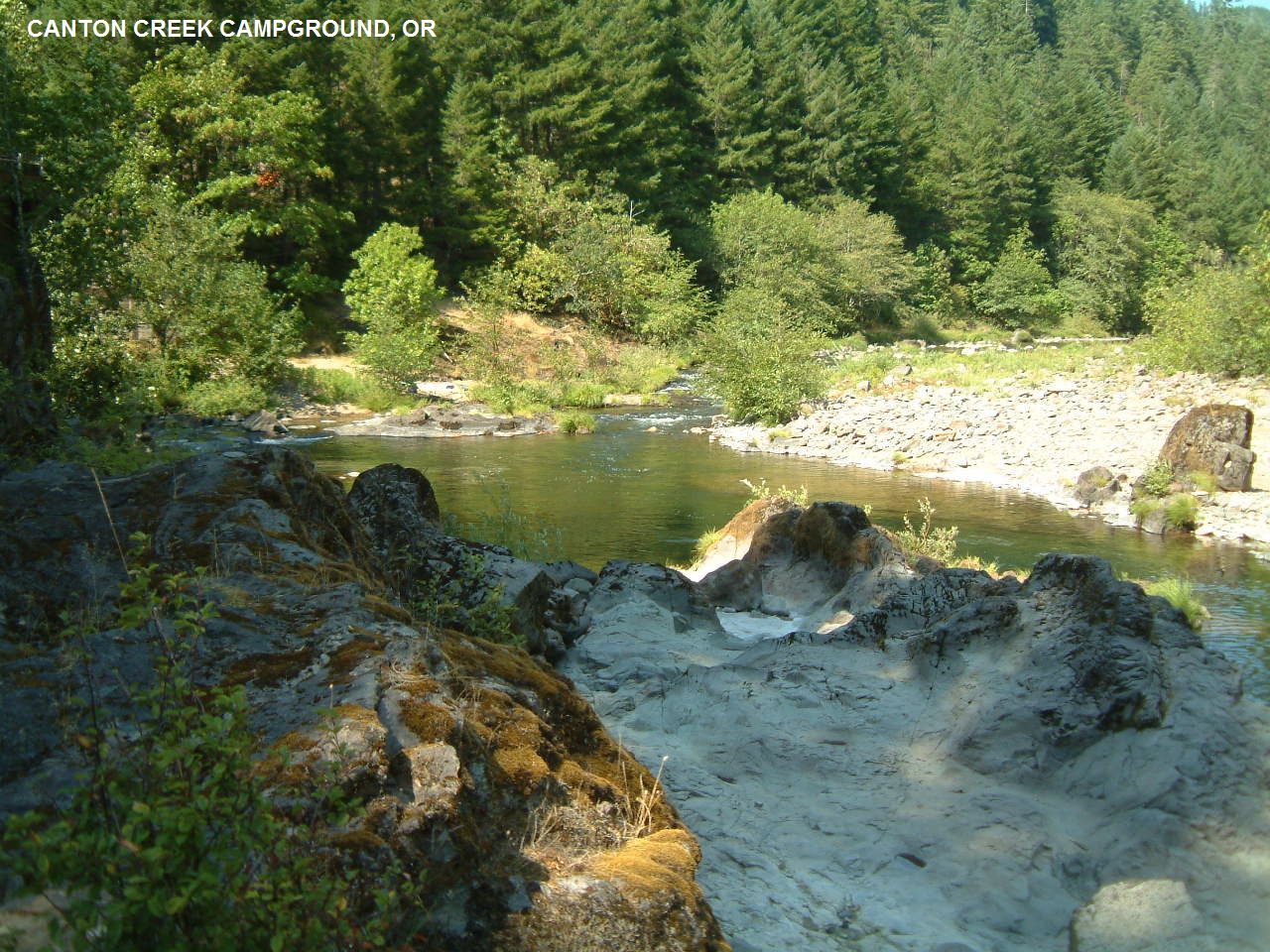
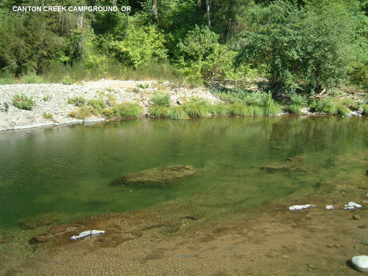
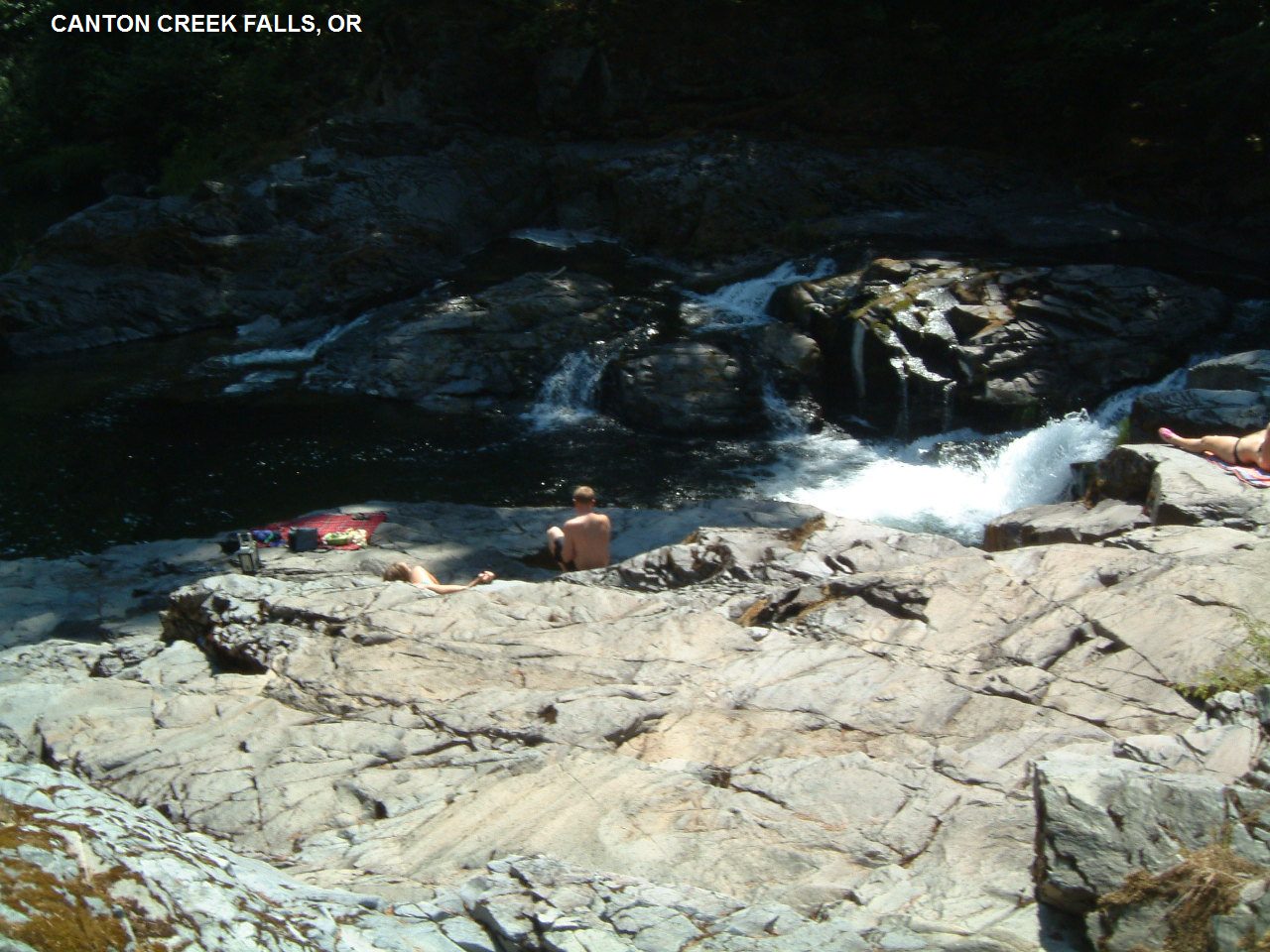
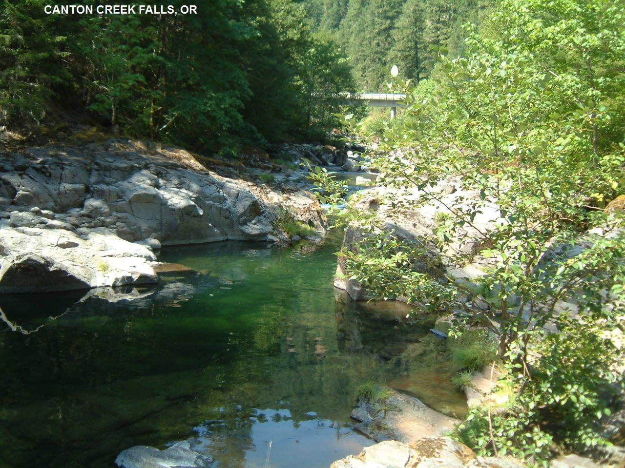
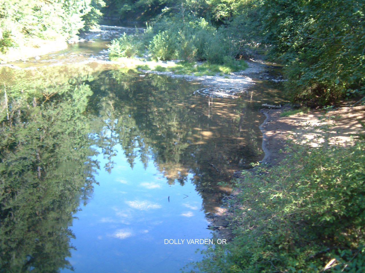
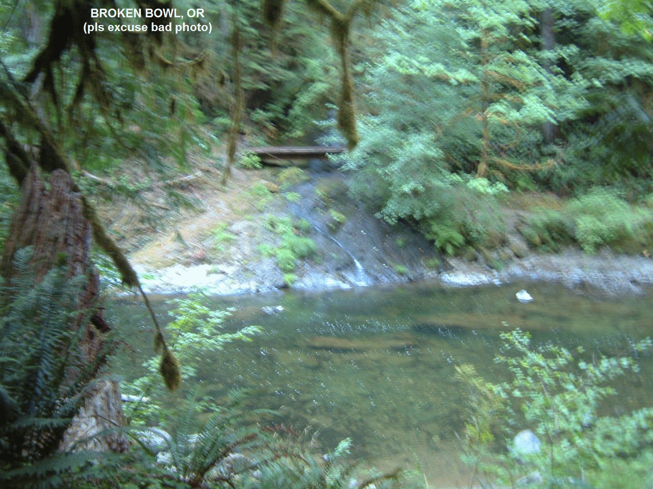
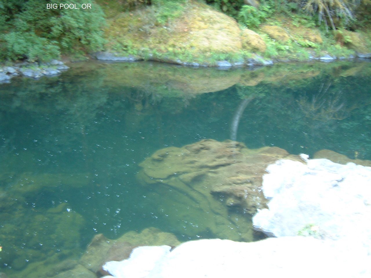
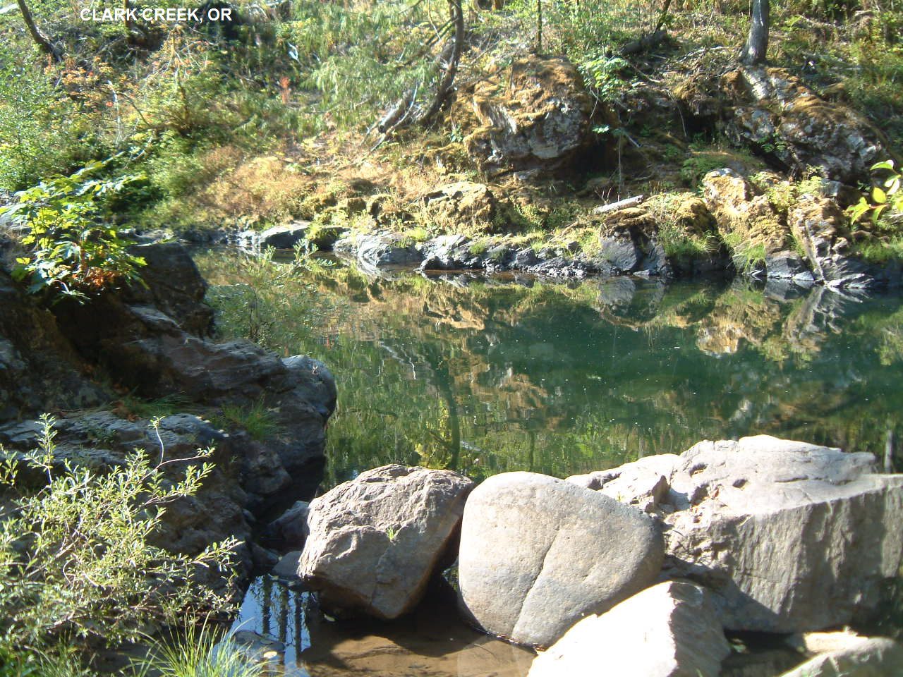
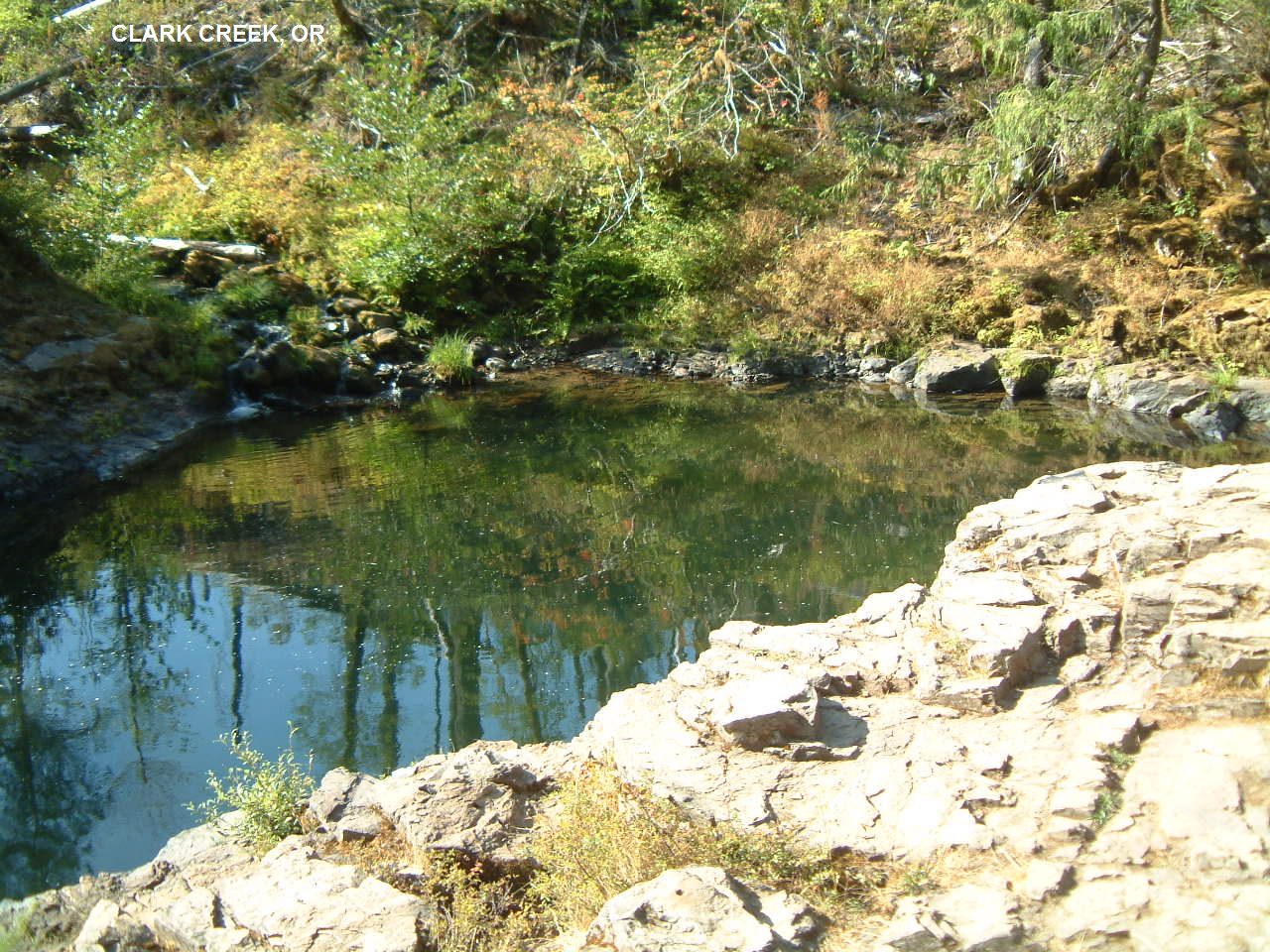
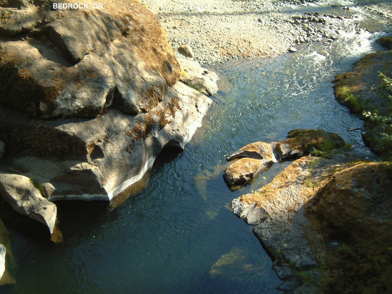
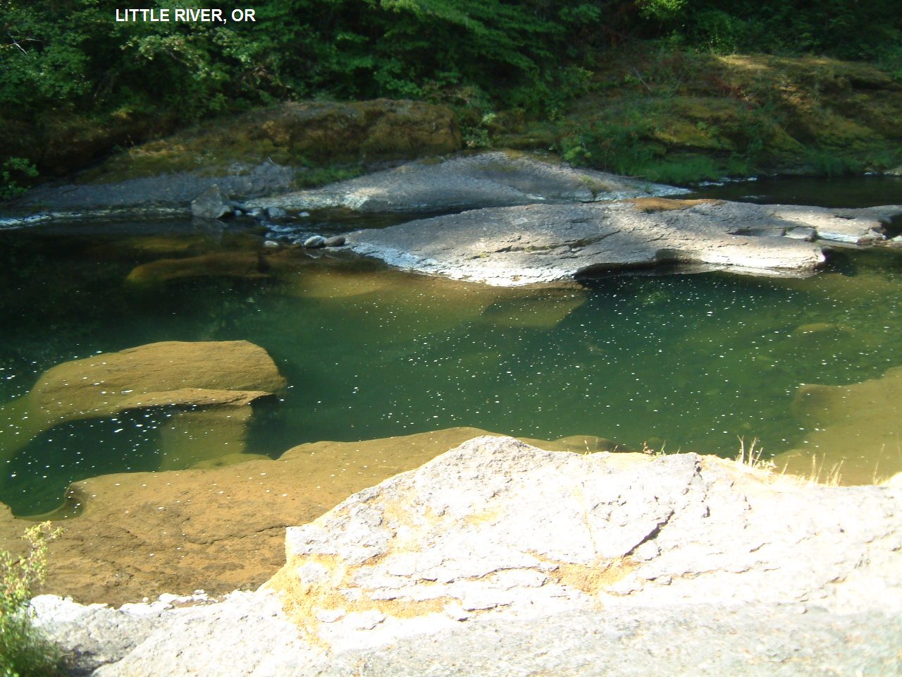
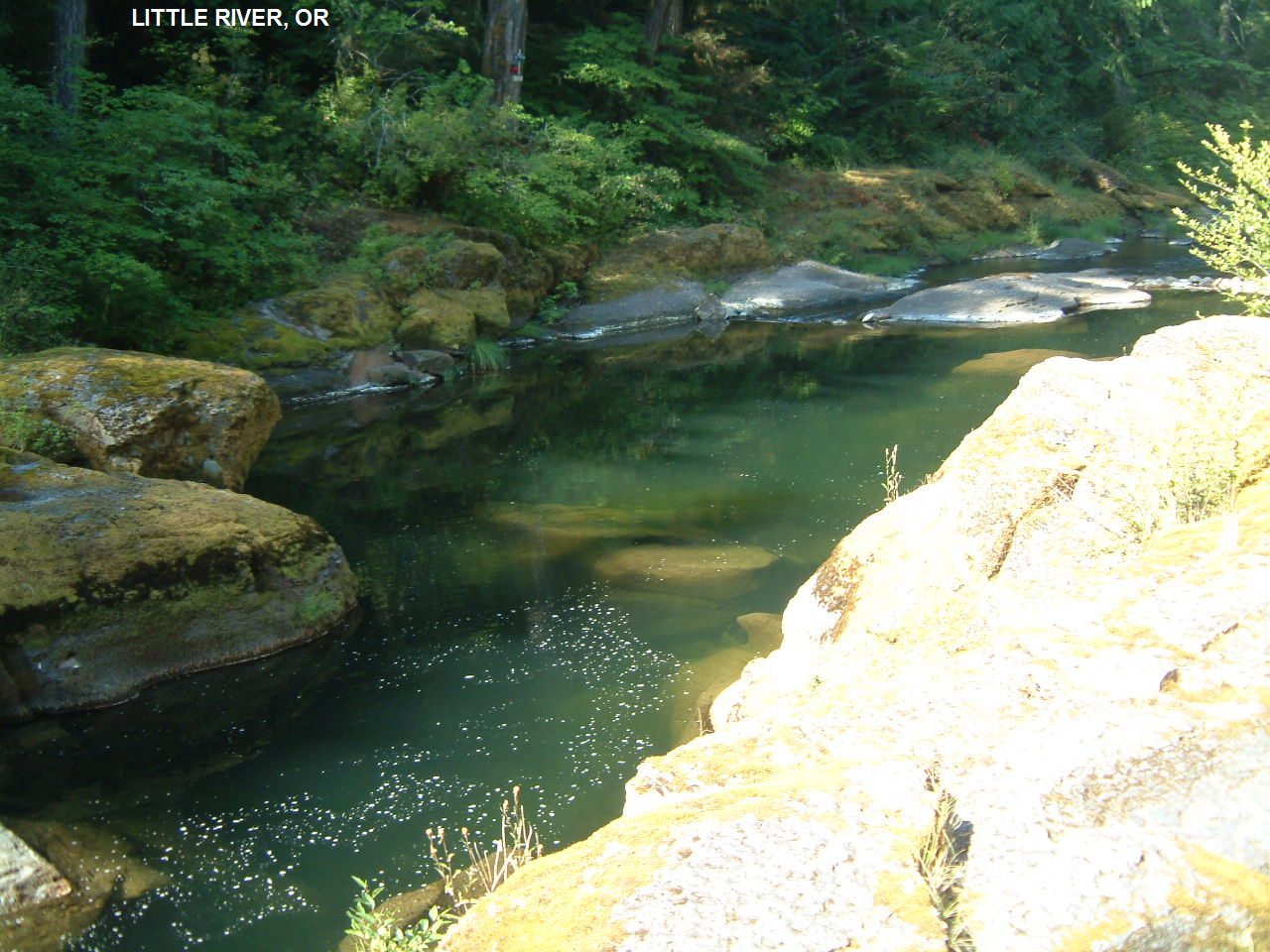
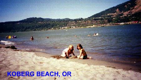
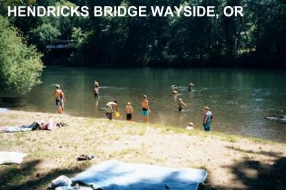
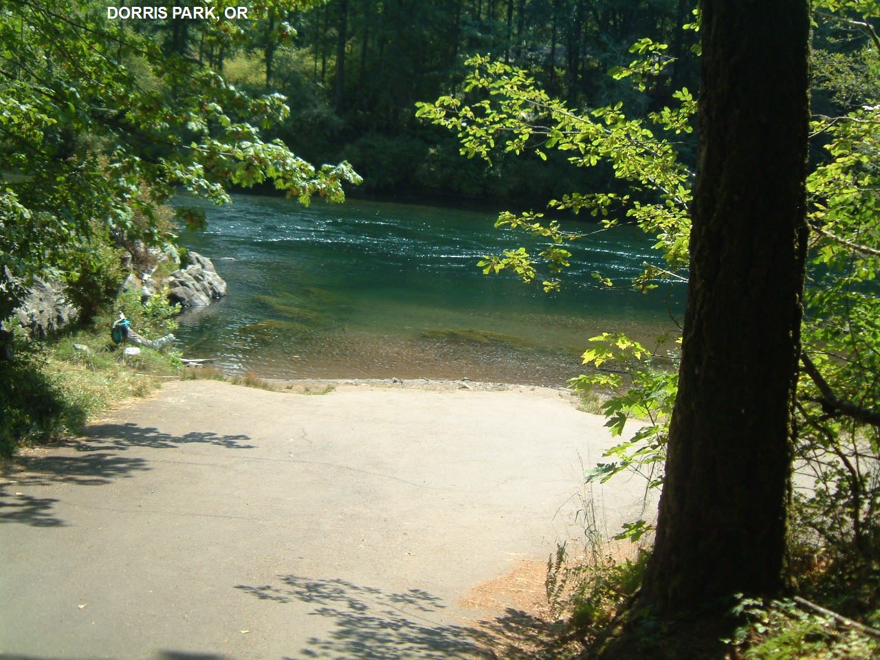
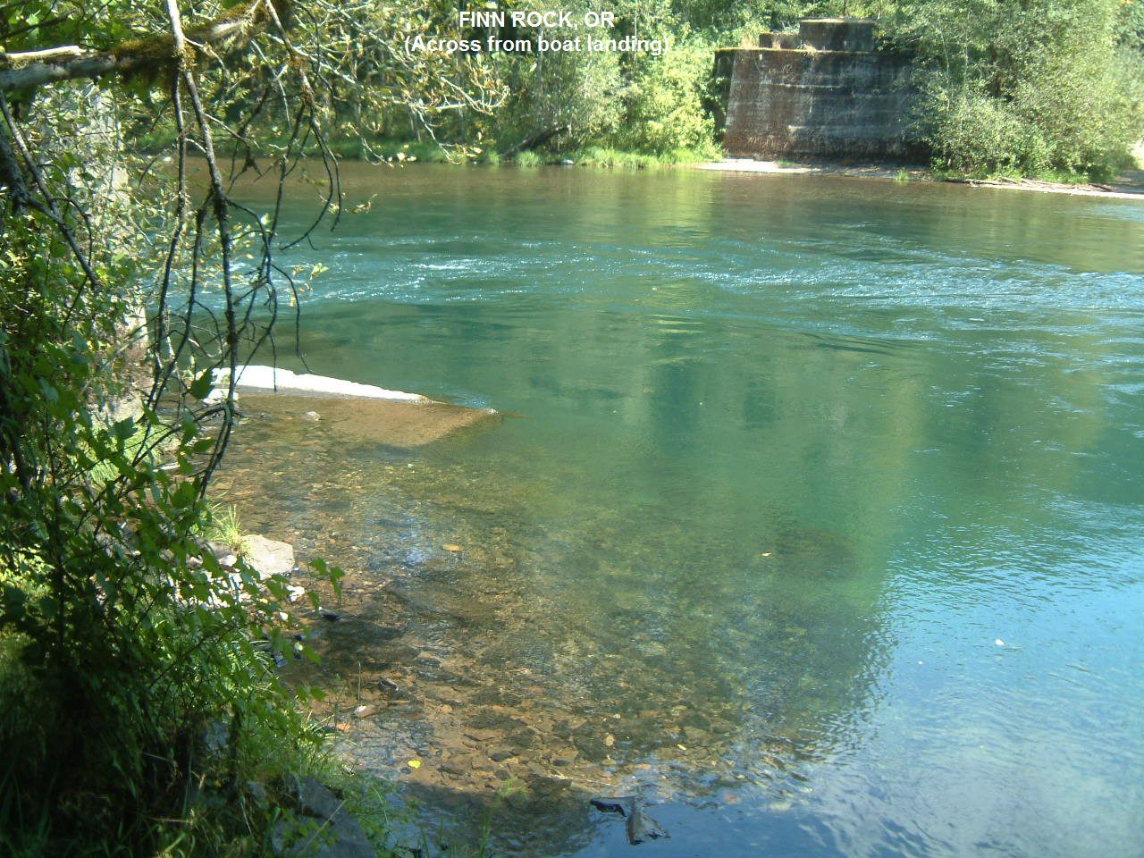
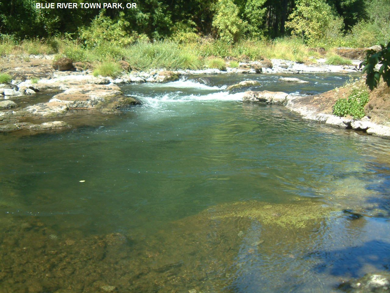
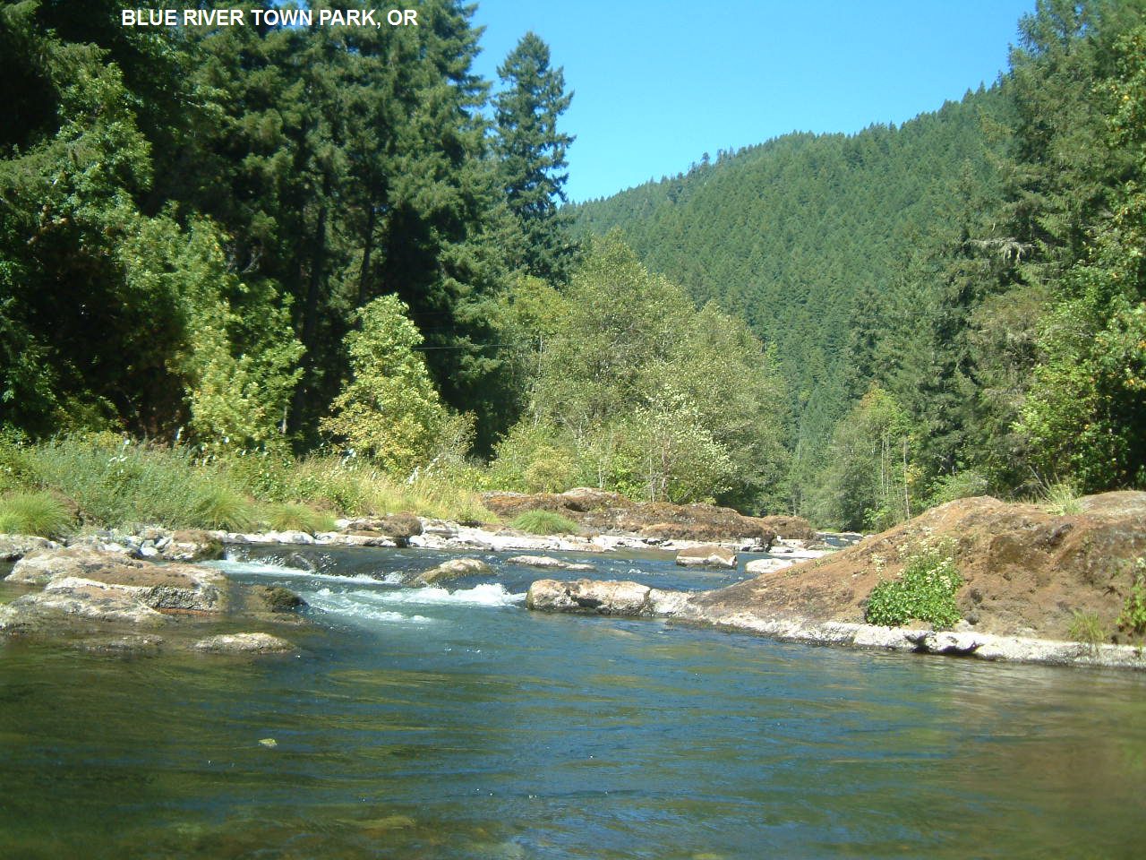
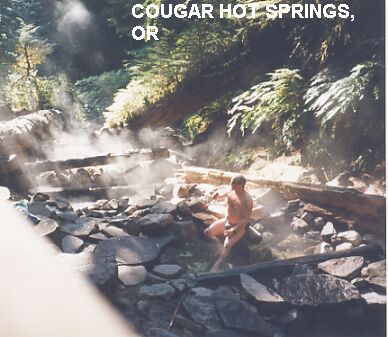
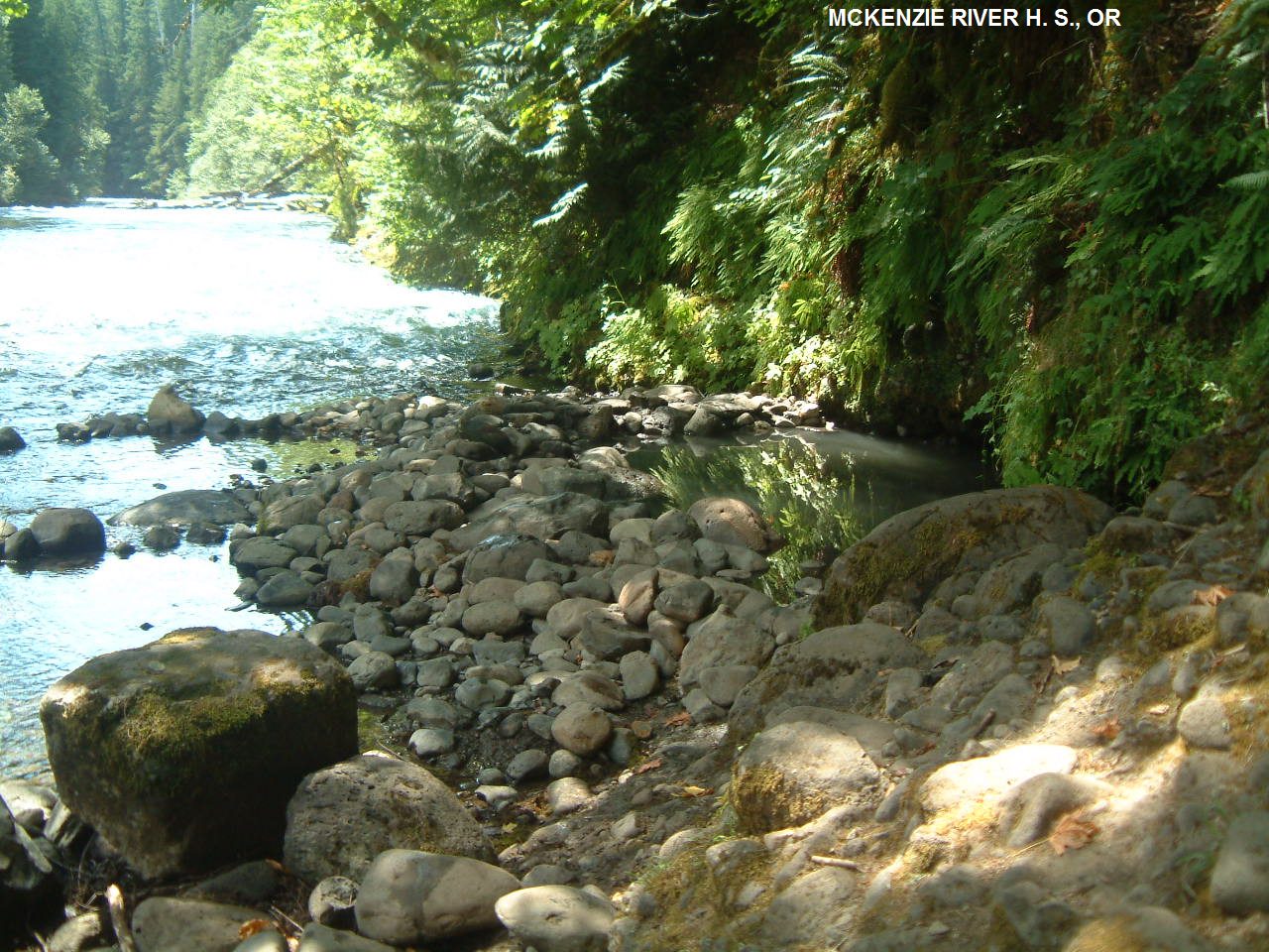
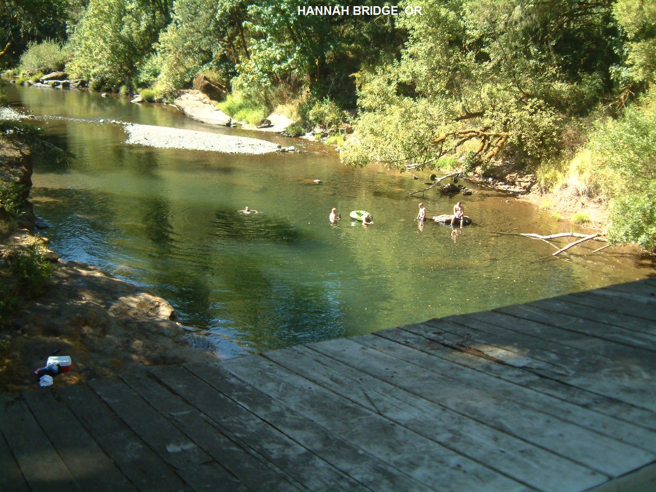
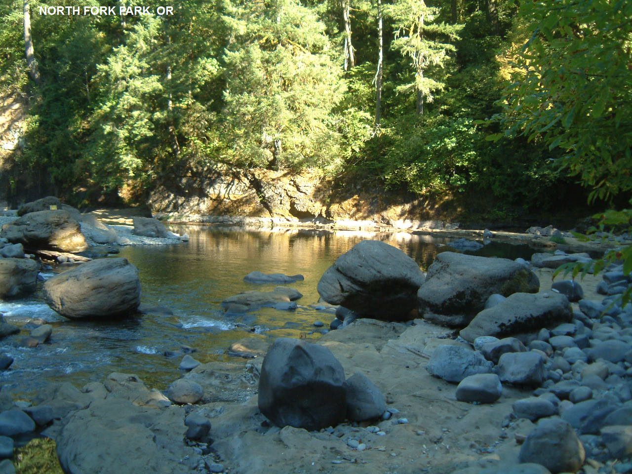
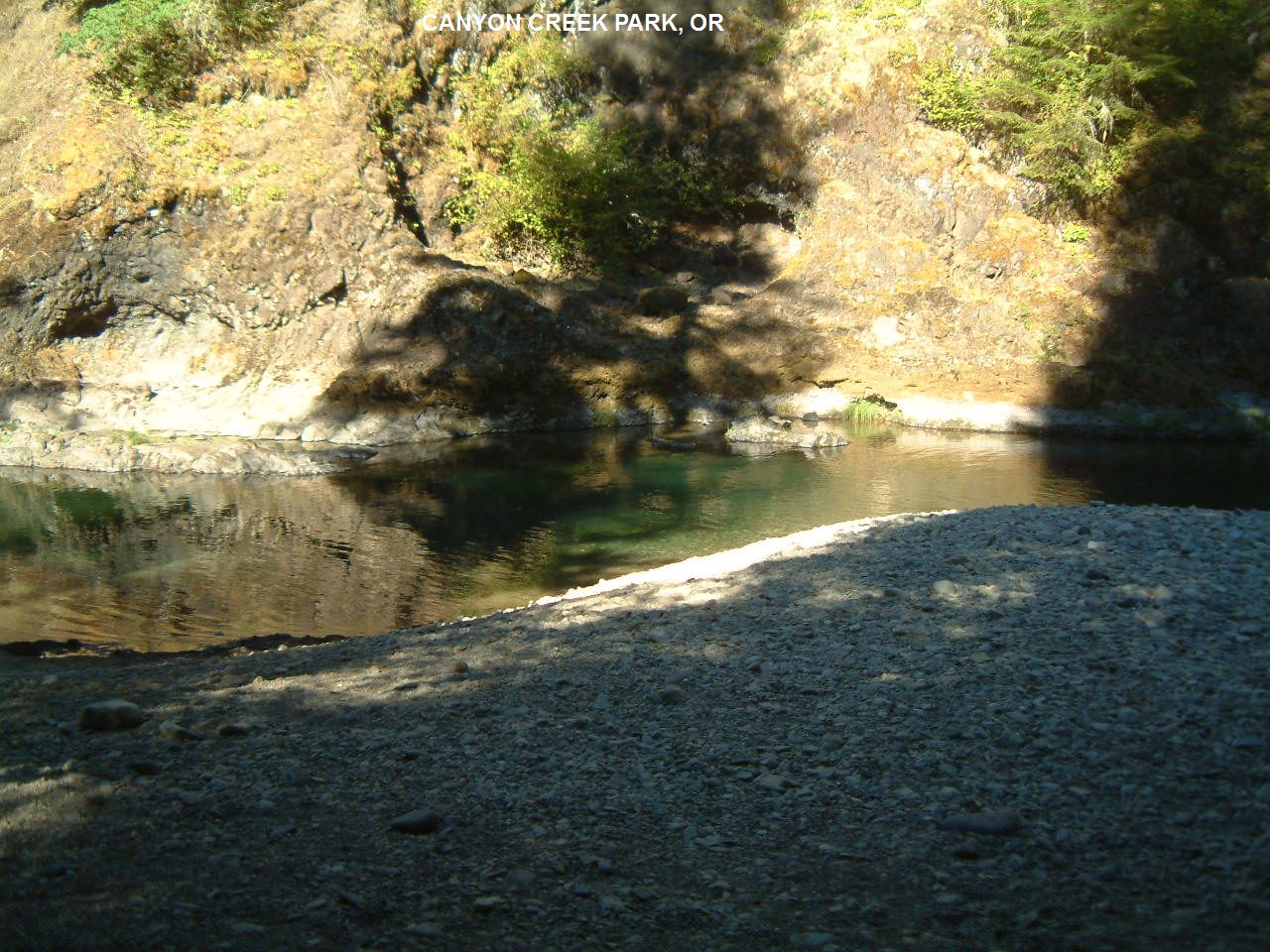
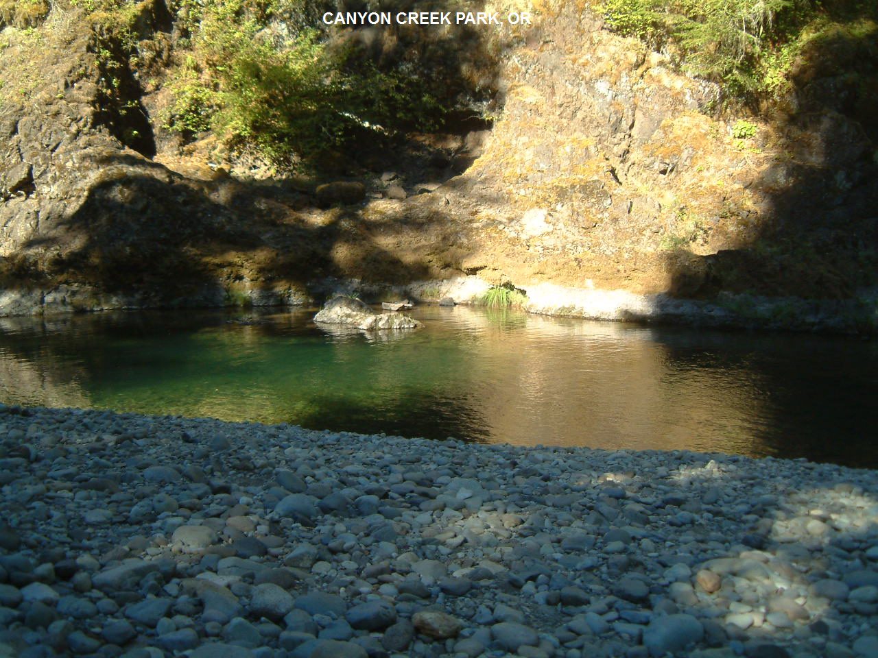
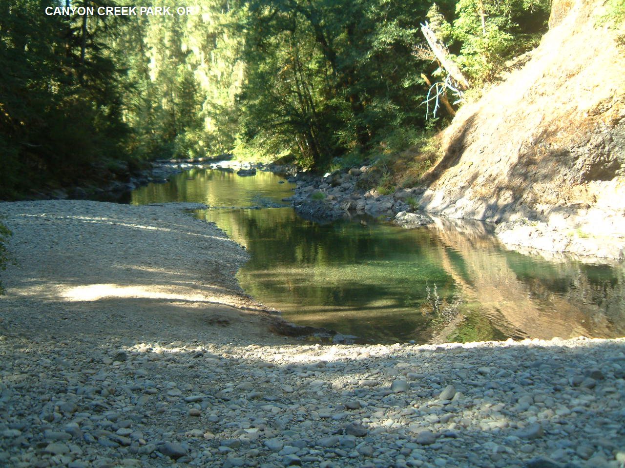
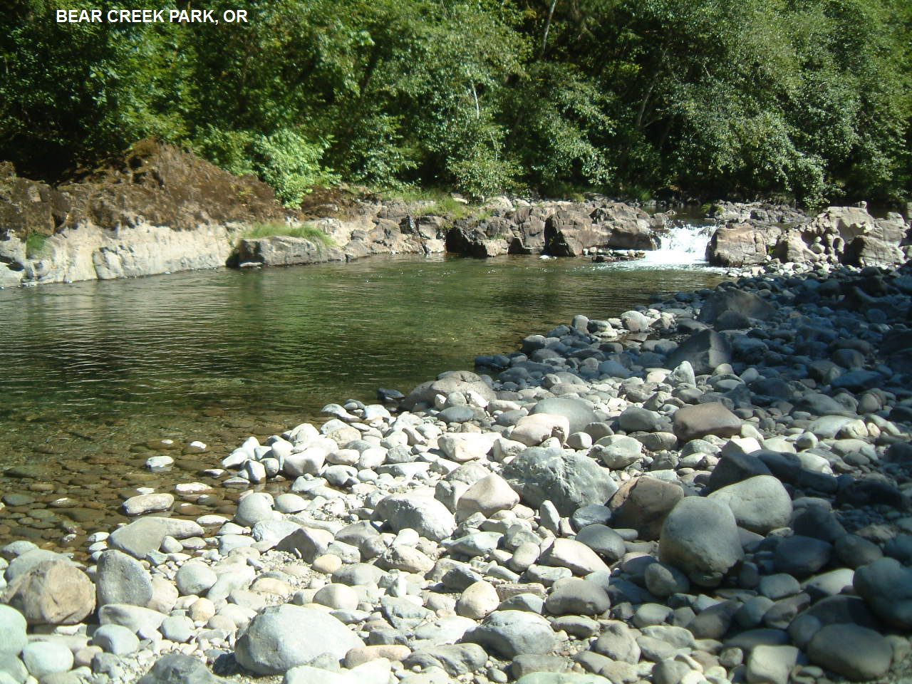
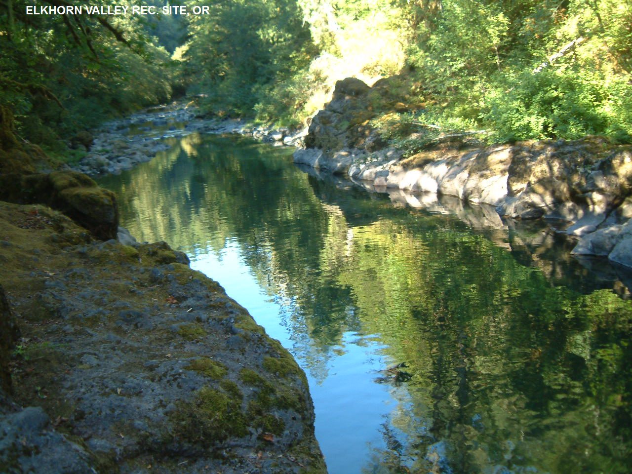
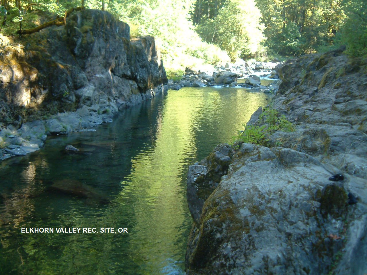
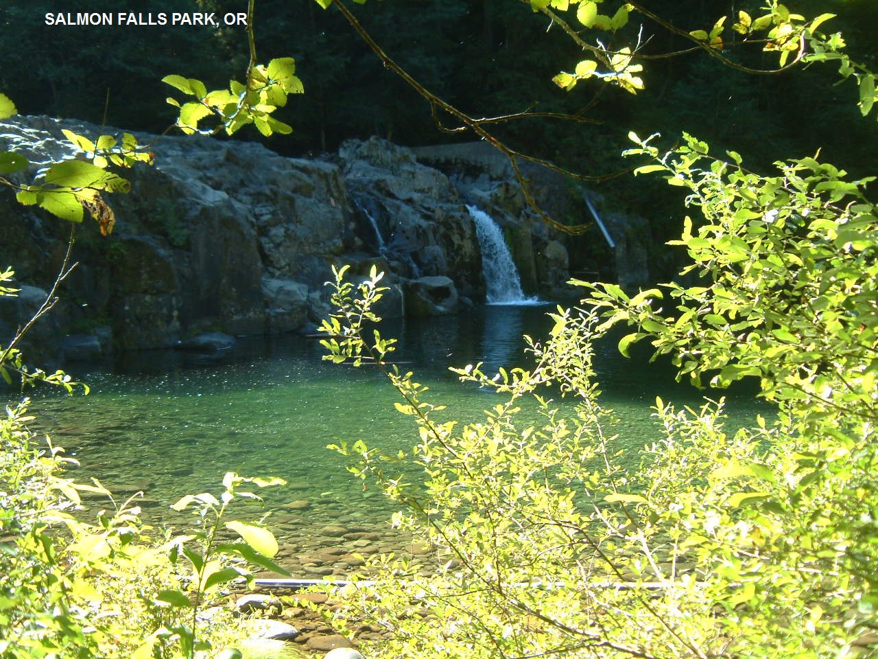
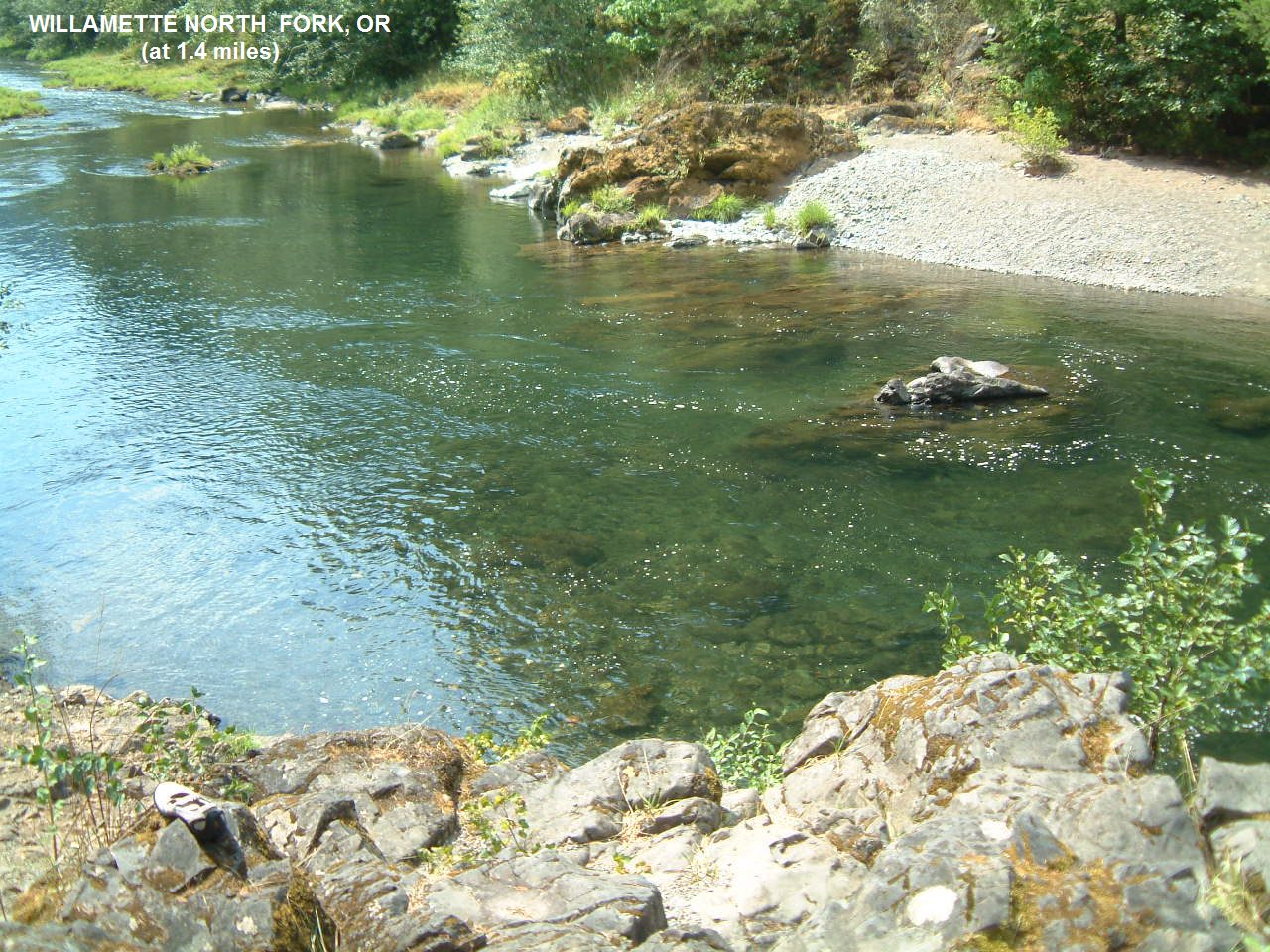
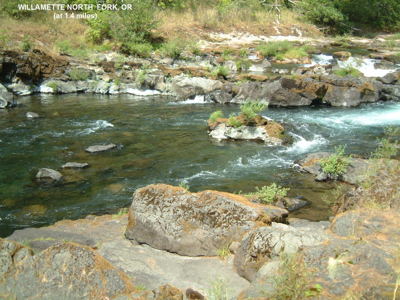
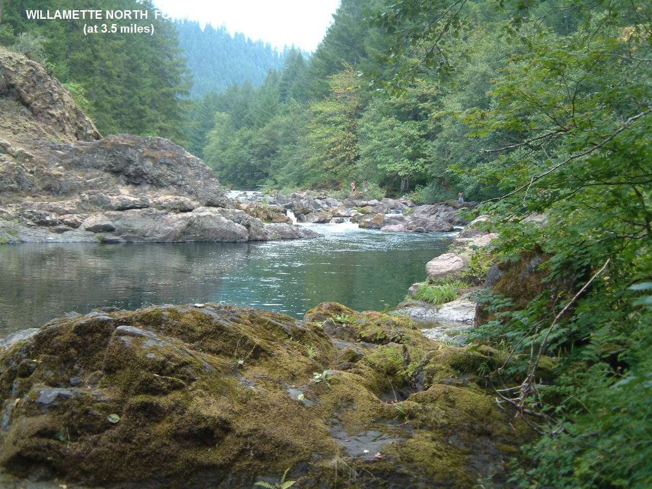
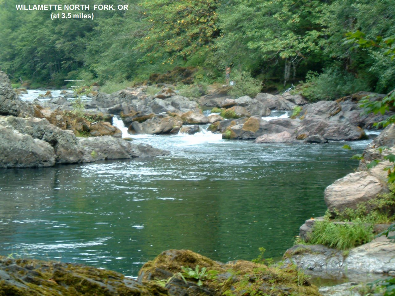
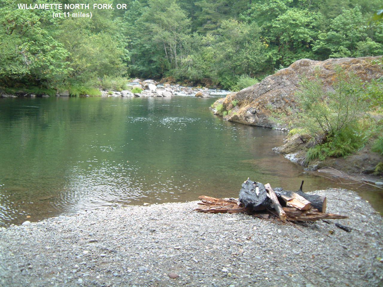
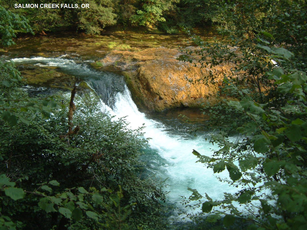
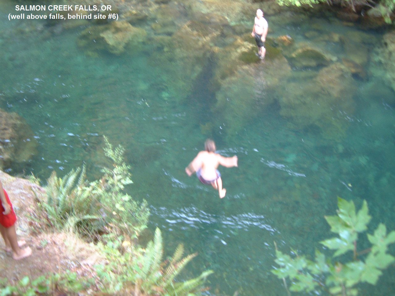
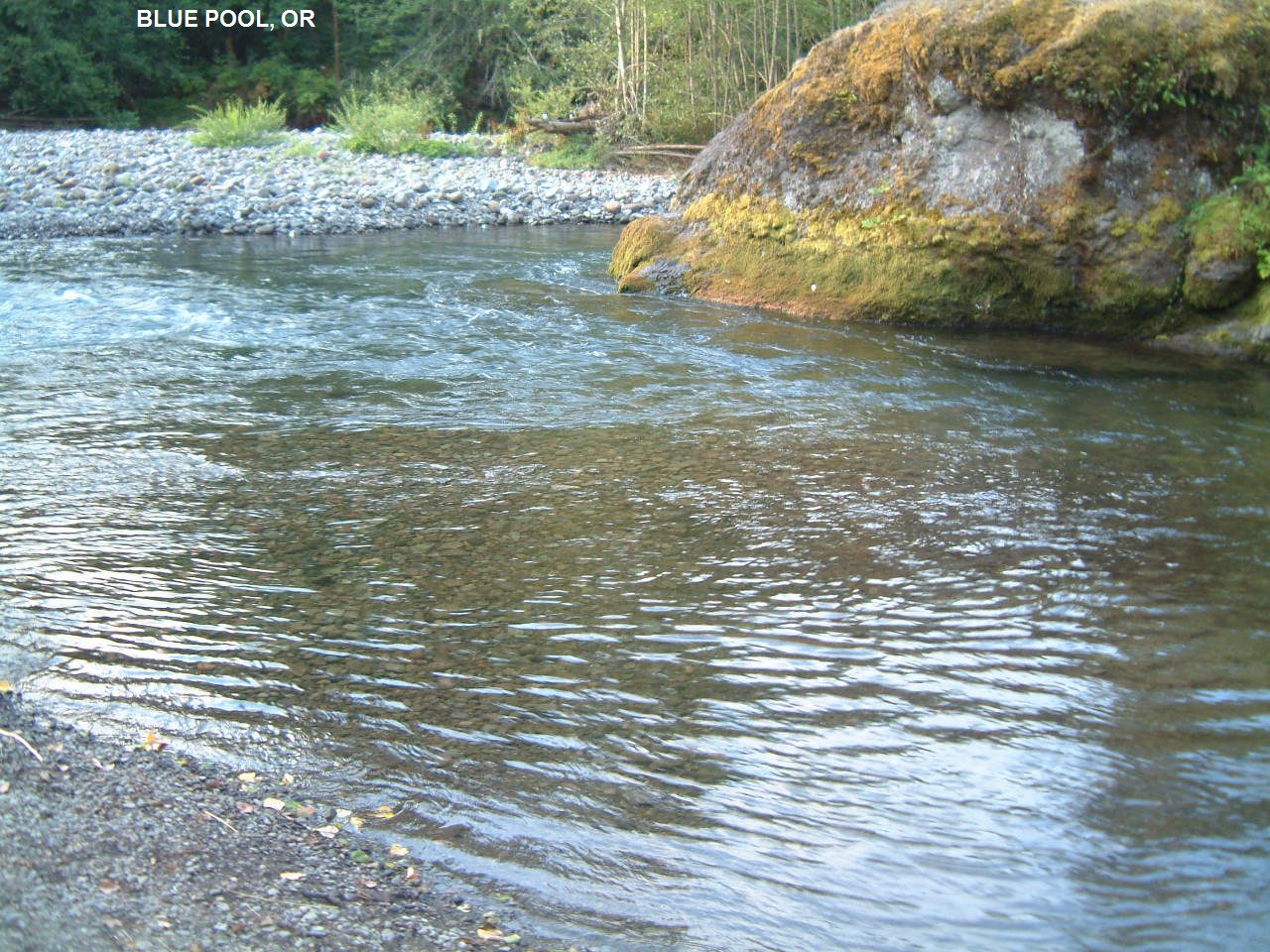
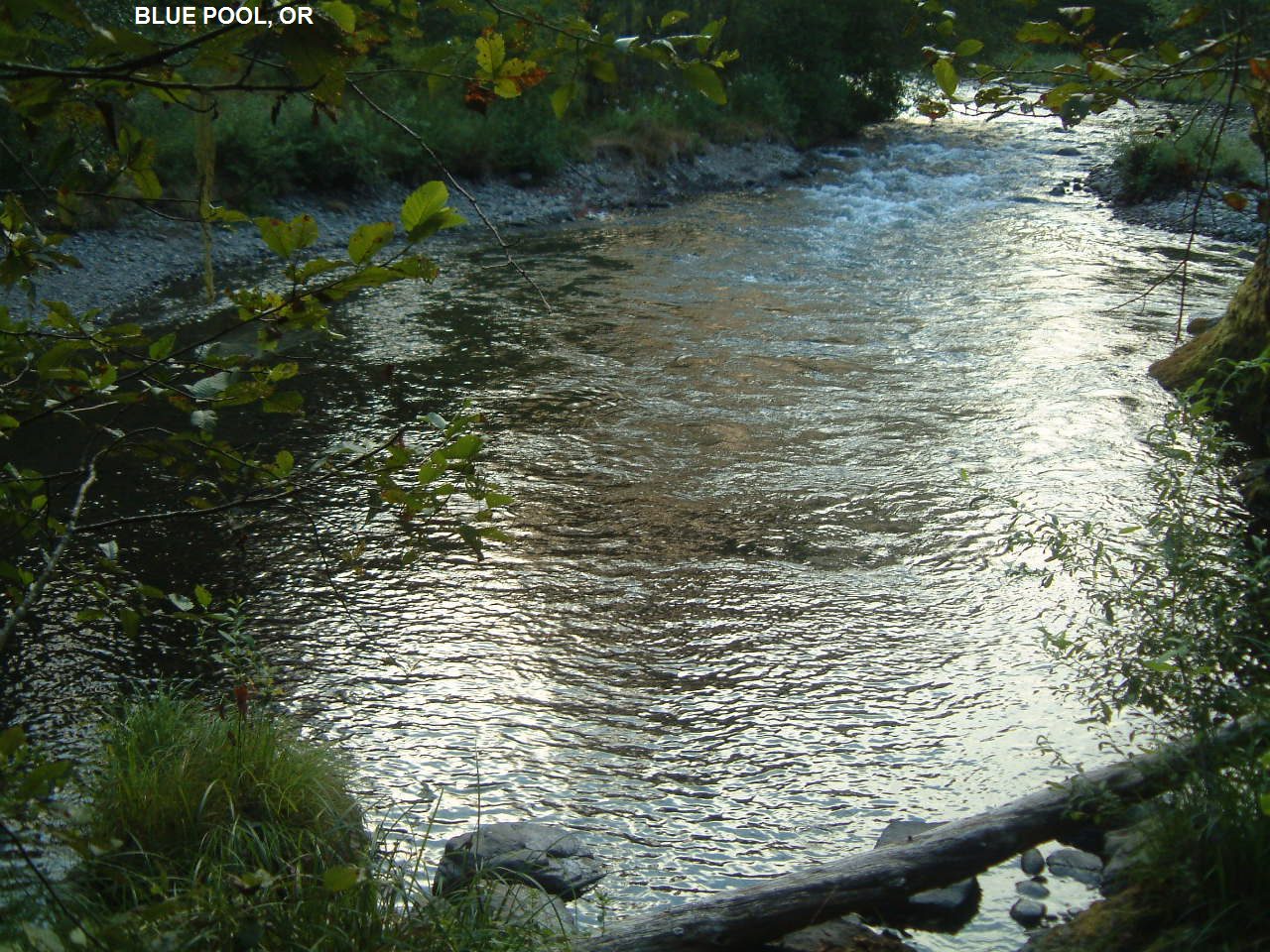
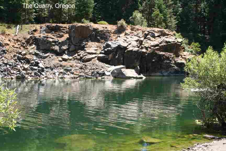
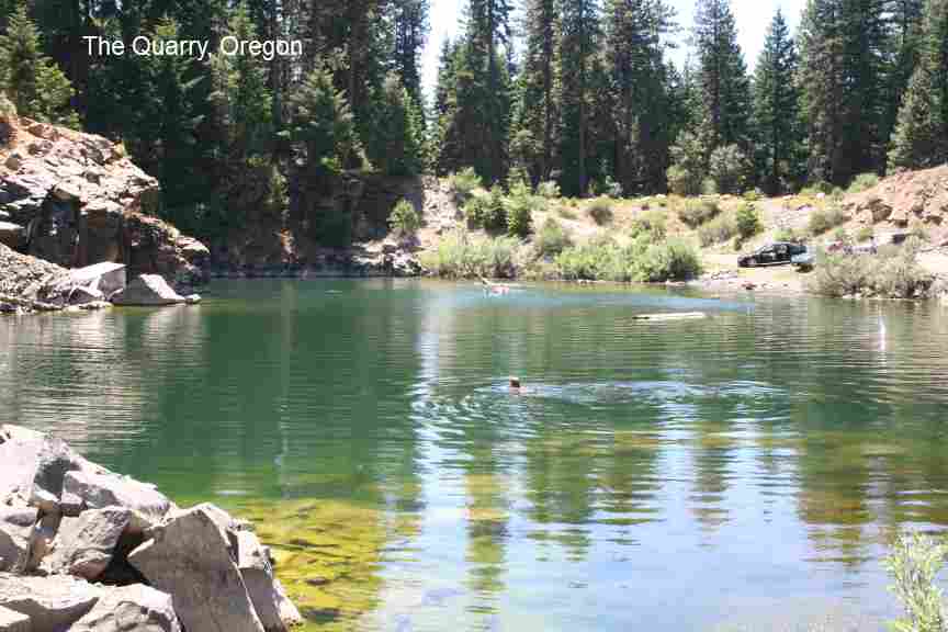
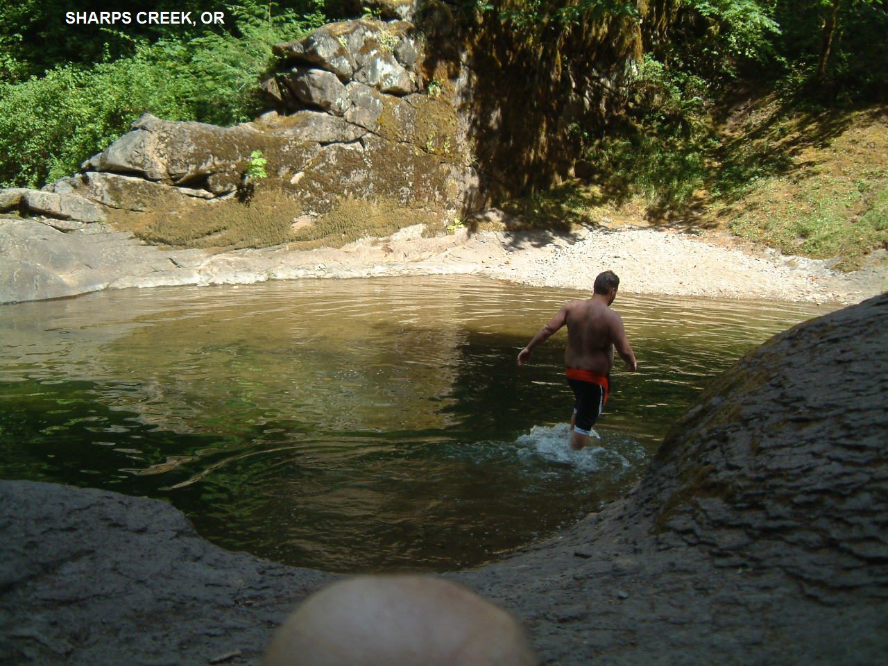
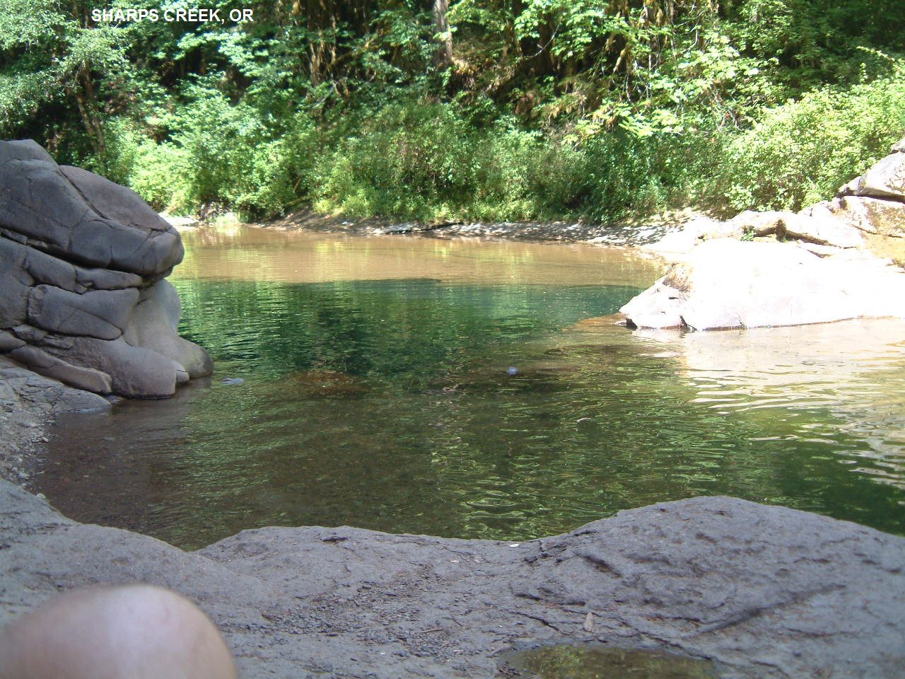
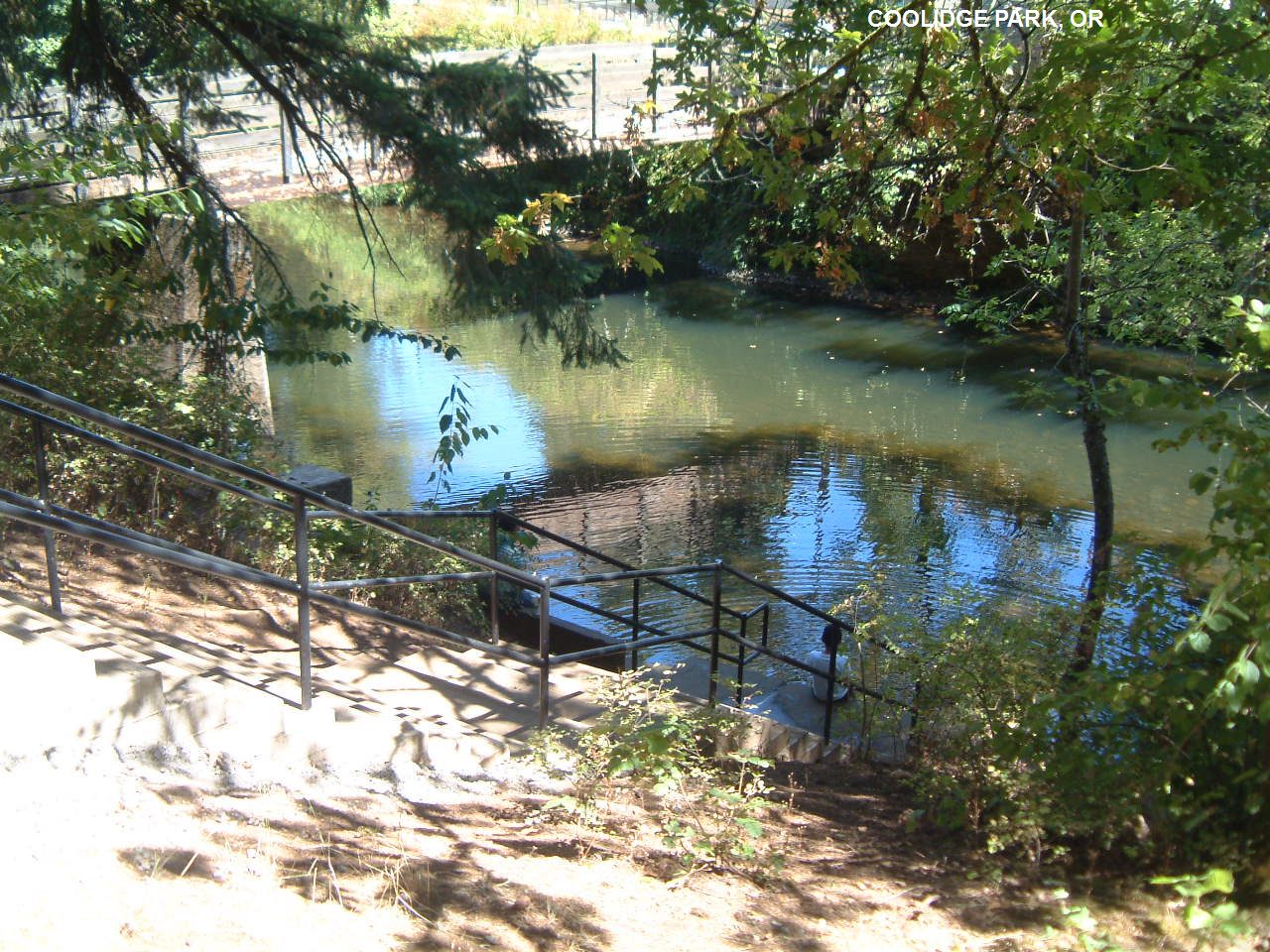
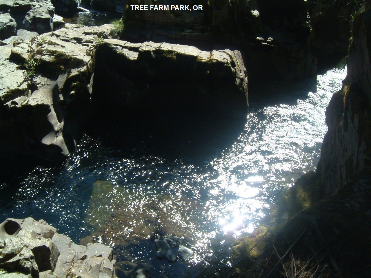
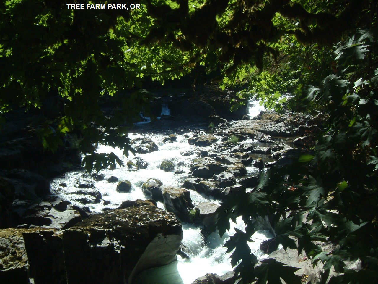
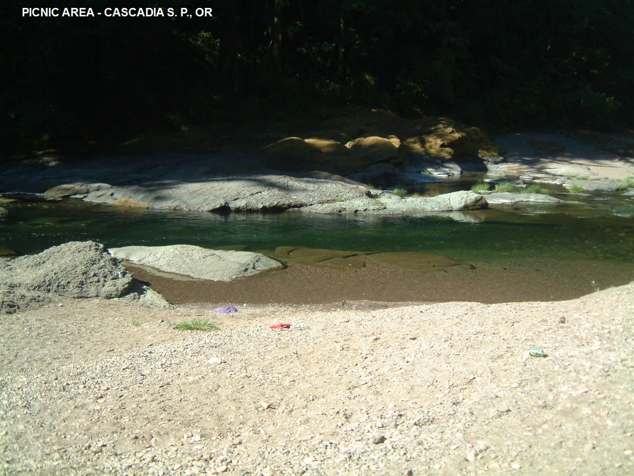
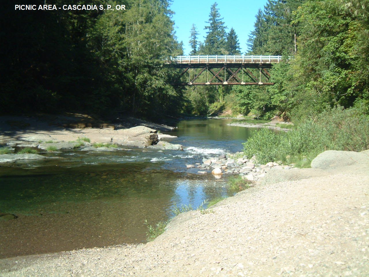
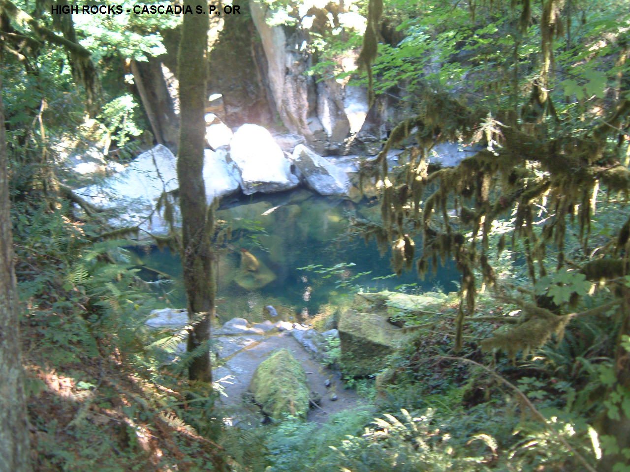
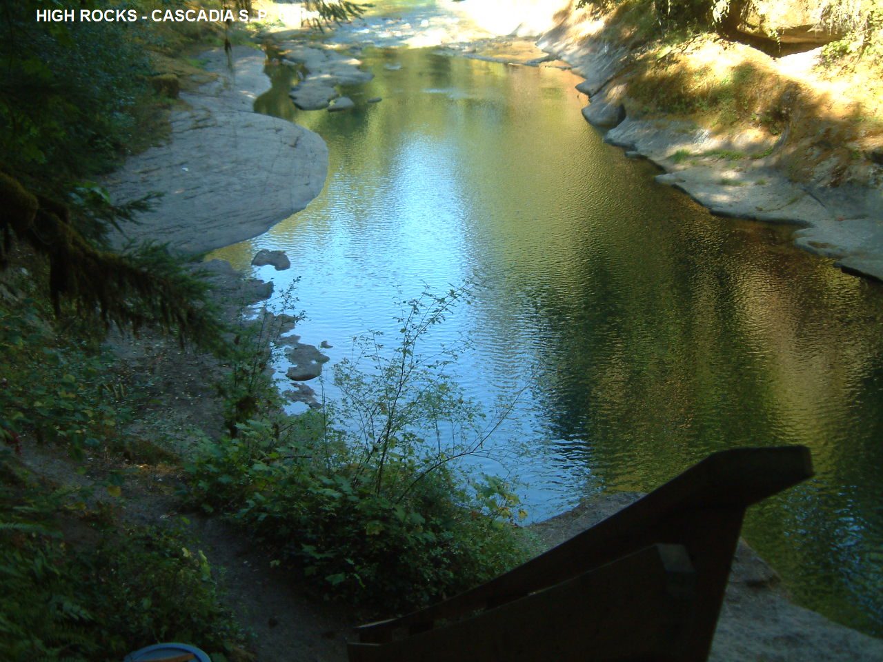
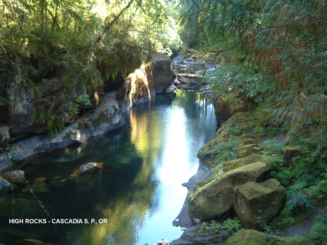
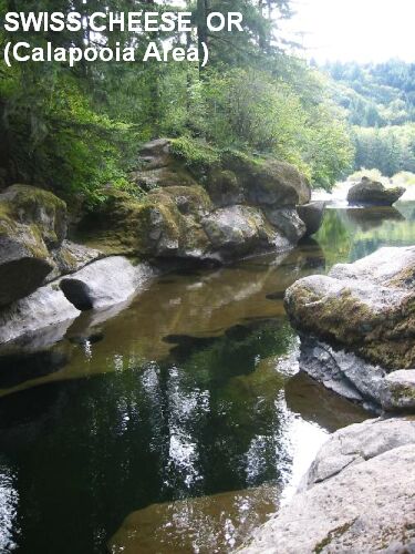
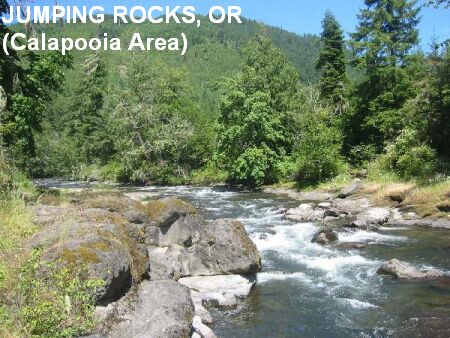
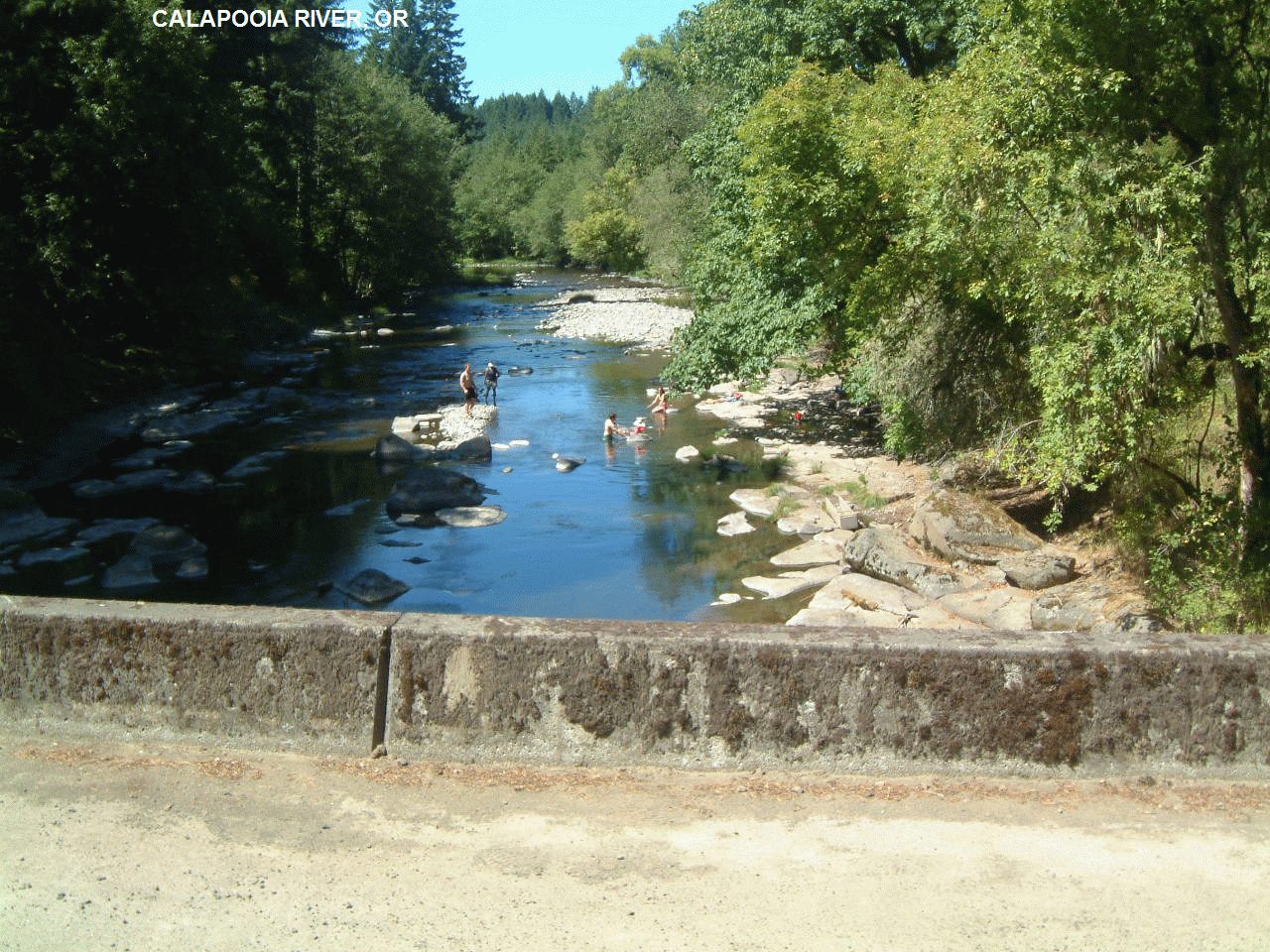
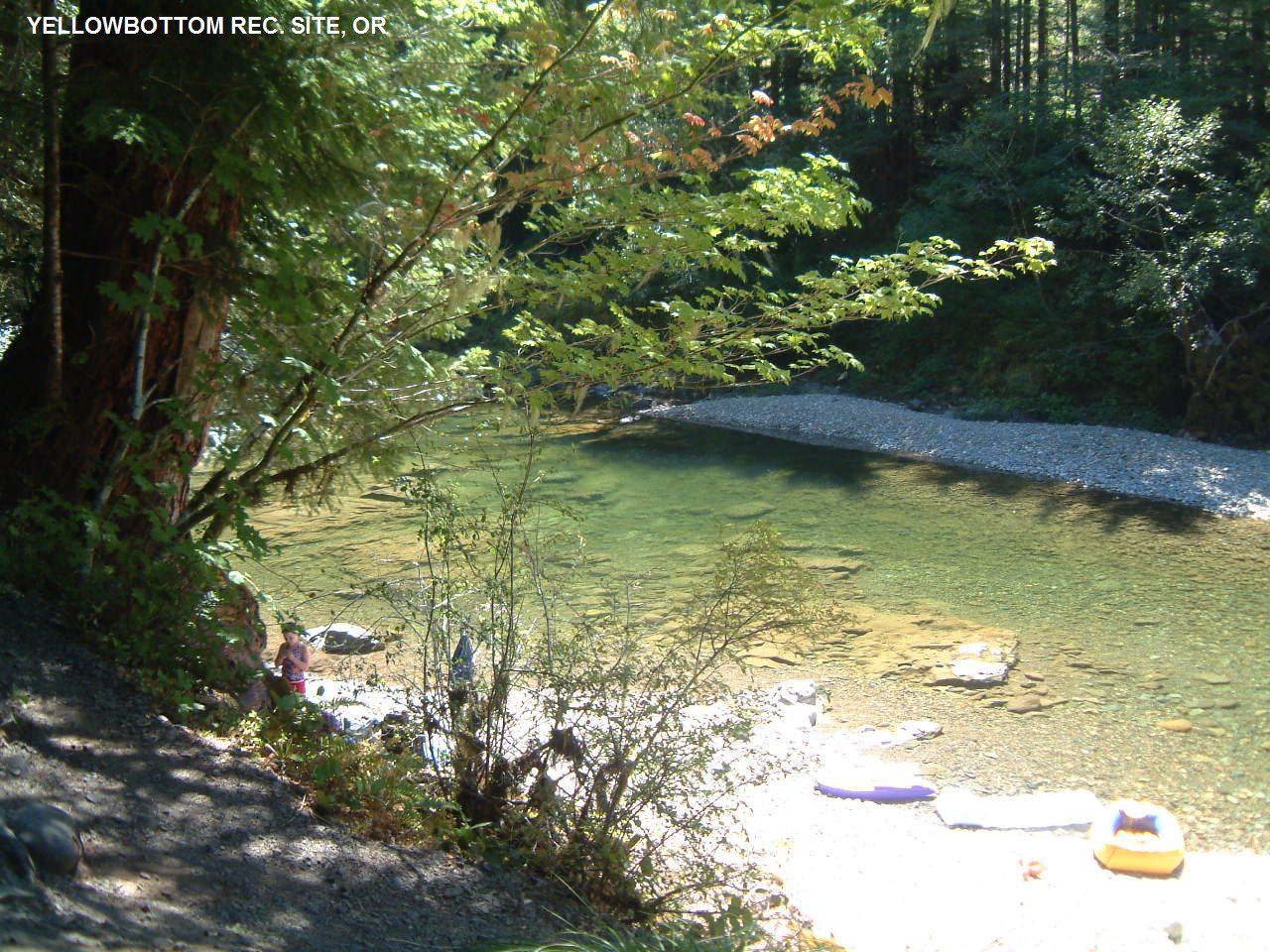
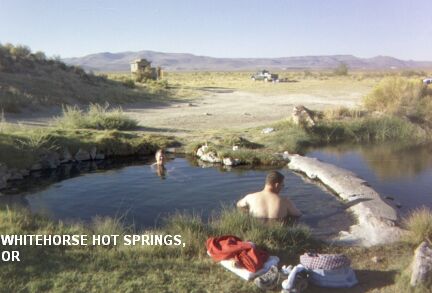