This swimming hole listing is by
www.swimmingholes.org
CHAPLIN AREA
[2 PLACES]
(CHAP)
|
|
| TOWNS |
HARTFORD, WILLIMANTIC, CHAPLIN |
| LAT, LON |
Lat:41.78023
Lon:-72.13017 Source : Measured
Accuracy : Exact
Link to Google Map |
| STATE |
CT |
| WATER |
Natchaug River |
| TYPE |
River |
| DESCRIPTION |
Two swimming places in Natchaug River.
Diana's Pool is popular with the students at the University of
Connecticut. |
| AREAS |
Unknown |
| SANCTION |
Varies |
| FEE |
No |
| FACILITIES
|
None |
| ACTIVITIES |
Swimming |
| PHONE |
None |
| CAMPING |
No camping at site; camp at Mashamoquet
Brook State Park northeast of here |
| BATHING
SUITS |
Customary |
| DIRECTIONS |
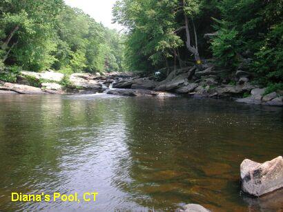
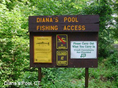
DIANA'S POOL [DIAN]: The pool is
very easy to find. From the intersection of Routes 6 and 198 in
Chaplin, follow Route 198 north for 0.5 miles. Just past the Chaplin
Fire house, turn right onto Diana's Pool road. There is a small parking
lot immediately on the left, enough for 6 or 7 cars. Park here and
follow the trail upstream. You will pass a few deep pools before you
reach the main pool. Diana's Pool is very large and has a beautiful 'S'
shaped, triple tiered waterfall PHOTO
1. Officially, there is no swimming at the pool PHOTO 2,
and this rule is enforced at times. It is a very popular place,
especially with students from the nearby University of Connecticut.
' People have died and have been seriously injured by jumping into
Diana's Pool from the rock outcroppings. Also, the rope swing has an
awkward takeoff and the landing area is very close to the rocks on the
edge of the water. Resist the temptation to use it. I watched one
person swing on it and decided that it was too dangerous.
ENGLAND'S BRIDGE [ENGL]: There is
another area, upstream of Diana's Pool that may be called England's
Bridge. The west bank of the river has what looks to be a wall made of
large stones, which may have been the old bridge abutment. This area
has huge boulders in the stream, perfect for sunning yourself.
|
| CONFIDENCE |
Very Confident |
| VERIFIED |
Yes |
| DATE
UPDATED |
1/11/2003 |
This swimming hole listing is by
www.swimmingholes.org
COTTON HOLLOW
(COTT)
|
|
| TOWNS |
GLASTONBURY |
| LAT, LON |
Lat:41.66204
Lon:-72.58880 Source : MapPoint
Accuracy : Approximate
Link to Google Map
|
| STATE |
CT |
| WATER |
Roaring Brook |
| TYPE |
Brook |
| DESCRIPTION |
A fast running
brook with a sandy bottom and rocky sides.
Fresh clear water. CAUTION
- Do not jump off high rocks here, it is very dangerous and there have
been
fatalities. This area is intended for Glastonbury residents only;
police are enforcing this rule.
|
| AREAS |
Cotton Hollow Preserve |
| SANCTION |
Unofficial |
| FEE |
No |
| FACILITIES
|
None |
| ACTIVITIES |
Swimming |
| PHONE |
None |
| CAMPING |
None |
| BATHING
SUITS |
Customary |
| DIRECTIONS |
Up Hopewell Rd from RT 17 in South
Glastonbury |
| CONFIDENCE |
Very Confident |
| VERIFIED |
Yes |
| DATE
UPDATED |
1/11/2003 |
This swimming hole listing is by
www.swimmingholes.org
HOTCHKISSVILLE BRIDGE
(HOTC)
|
|
| TOWNS |
WOODBURY, WATERTOWN |
| LAT, LON |
Lat:41.56766
Lon:-73.21848 Source : Measured
Accuracy : Exact
Link to Google Map
|
| STATE |
CT |
| WATER |
Weekeepeemee River |
| TYPE |
Stream |
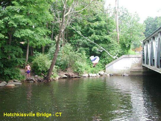
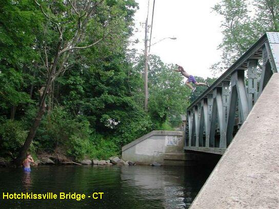
| DESCRIPTION |
A meandering
stream that has carved out a nice hole in a bend in the Weekeepeemee
river. Not exceptionally deep, but deep enough in the center of the
pool to jump from the bridge and ride the sturdy rope swing. Several
trees are fitted with ladder steps to accommodate your airtime needs. CAUTION
- Check the depth of the pool before you jump
in; watch the locals jump first to get an idea of the landing area. The
Weekeepeemee is a small stream and water levels can vary greatly. This
is a popular teenager hangout, not suitable for small children.
|
| AREAS |
None |
| SANCTION |
Unofficial |
| FEE |
No |
| FACILITIES
|
None |
| ACTIVITIES |
Swimming, Jumping, Rope Swing |
| PHONE |
None |
| CAMPING |
None |
| BATHING
SUITS |
Customary |
| DIRECTIONS |
From the
intersection of RT 6 and RT 47 in Woodbury, follow RT 47 north toward
the borough of Hotchkissville. Just past the RT 132 intersection which
forks to the right, stay on RT 47 and cross over an iron bridge. You
can park on the right just after the bridge. There is a somewhat larger
parking area a bit further down RT 47 on the left.
|
| CONFIDENCE |
Very Confident |
| VERIFIED |
Yes |
| DATE
UPDATED |
06/29/03 |
This swimming hole listing is by
www.swimmingholes.org
INDIAN WELL STATE PARK
(INDI)
|
|
| TOWNS |
BRIDGEPORT, NEW HAVEN, SHELTON |
| LAT, LON |
Lat:41.34043
Lon:-73.12477 Source : MapPoint
Accuracy : Approximate
Link to Google Map
|
| STATE |
CT |
| WATER |
Unknown creek and Housatonic River |
|
TYPE |
Falls/River |
| DESCRIPTION |
Scenic waterfall
in creek with swimming in a deep, small pool at
the bottom dammed up with rocks (photo above). Also official swimming
beach on river with
lifeguard and facilities (no photo). Note that some readers have
reported that the police will occasionally patrol this swimming hole
and may issue fines.
|
| AREAS |
Indian Well State Park |
| SANCTION |
Unofficial at falls, official at river
beach. |
| FEE |
Free at falls, $5.00 per car at river
beach. |
| FACILITIES
|
Picnic Tables, Toilets at State Park |
| ACTIVITIES |
Swimming |
| PHONE |
None |
| CAMPING |
None at site. |
| BATHING
SUITS |
Unknown at falls, required at river
beach. |
| DIRECTIONS |
From New Haven,
take RT 34 west to toward Shelton. Just past the underpass for RT 8,
take a left onto Bridge Street; you will cross the river at this point.
Take a right onto Howe Ave, this is RT 110 North. Follow RT
110 north about 2 miles and follow signs to Indian Well State Park.
Just before you enter the State
Park, see a sign on the left for the trail to the falls, and a parking
area on the right. Park here and
take a very short hike to the falls and the pool below. There are signs
here that say "no
swimming". The State Park beach on the river is just a bit further on
this
road.
|
| CONFIDENCE |
Very Confident |
| VERIFIED |
Yes |
| DATE
UPDATED |
01/06/2007 |
This swimming hole listing is by
www.swimmingholes.org
LAKE
MASHAPAUG
(MASH)
|
|
| TOWNS |
STAFFORD SPRINGS |
| LAT, LON |
Lat:42.00985 Lon:-72.13017 Source : Measured
Accuracy : Exact
Link to Google Map
|
|
STATE |
CT |
| WATER |
Lake Mashapaug |
| TYPE |
Lake |
| DESCRIPTION |
Swimming in an unsupervised, bucolic area of a very large,
clearwater lake. Though state parks are not usually included
on our website, this spot is particularly beautiful and
unique. The portion of Bigelow Hollow State Park on the
southern shore of Lake Mashapaug is dotted with picnic areas, small
islands and rock formations inviting swimmers. A short walk through
the woods leads to the largest rock outcropping PHOTO
1 which is great for sun bathing and taking in the view of the
entire lake. A submerged rock formation PHOTO
2 just offshore is an easy swim and begs for exploration. To the
right of the large rock, is a sizeable shallow, sandy area PHOTO
3 that is perfect for those who are more comfortable with
wading. Get here early to claim your picnic spot.
|
| AREAS |
Bigelow Hollow State Park |
| SANCTION |
Official |
| FEE |
The CT DEP charges a nominal fee to enter the park. |
| FACILITIES
|
None |
| ACTIVITIES |
Swimming |
| PHONE |
None |
| CAMPING |
None at site |
| BATHING
SUITS |
Customary |
| DIRECTIONS |
Follow interstate 84 to Exit 73 then follow RT
190 north. Take a right on RT 171 East to the park entrance. on your
left. Once in the park, follow the park road past Bigelow Pond on
your left (a sizeable pond itself) to the boat launch for lake
Mashapaug. Park here and follow the obvious train along the
shoreline. Follow the signs for "Rock Island" PHOTO
4. It's about a 15 minute walk to the large rock..
|
| CONFIDENCE |
Very Confident |
| VERIFIED |
Yes |
|
DATE UPDATED |
02/24/2008 |
This swimming hole listing is by
www.swimmingholes.org
MILLER POND
(MILL)
|
|
| TOWNS |
MIDDLETOWN, DURHAM |
| LAT, LON |
Lat:41.47968
Lon:-72.63186 Source : Measured
Accuracy : Exact
Link to Google Map
|
|
STATE |
CT |
| WATER |
Miller Pond State Park |
| TYPE |
Lake |
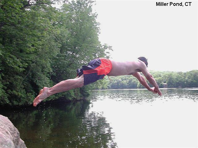
| DESCRIPTION |
Swimming in a very
large pond or more accurately a small lake. There are several small
beaches and low angle sloping rock outcrops along the perimeter of the
lake, some with picnic tables. This is a beautiful, deep lake that is
very popular in the summer; the small parking lot fills up quickly on
the weekends. Because there are so many small access points scattered
around the lake, the area can accommodate many people but you can have
your own little swimming area that is relatively private. When you
arrive at the lake, just follow the well worn path that follows the
shoreline and find yourself a place to call your own. This is
an excellent place to stop in at the end of the day for a refreshing
swim. The State of Connecticut DEP
now prohibits jumping from the cliffs on the west side of the pond. Beginning in 2007, DEP officers will issue a
fine of $75 to anyone who jumps or dives from the western cliffs or
uses the rope swing.
|
| AREAS |
Miller Pond State Park |
| SANCTION |
Official |
| FEE |
None |
| FACILITIES
|
None |
| ACTIVITIES |
Swimming |
| PHONE |
None |
| CAMPING |
None at site |
| BATHING
SUITS |
Customary |
| DIRECTIONS |
From Middletown,
follow RT 17 South into Durham. Just past the intersection with RT 147,
turn left onto Haddam Quarter Road. This road is very hilly and curvy,
so be careful. Go straight at the first 4-way intersection then take a
right at the second 4-way intersection onto Foothills Rd. The fenced
parking lot will be on your right; do not park on the road. During the
peak summer months, the parking lot fills up quickly on the weekend and
you may see cars parked on along the roadside; if the lot is full when
you visit, plan to return at another time. If you arrive before 10:00
AM, you should have no problem finding a space. If you visit during the
week, you just might have this entire, beautiful lake all to yourself!
|
| CONFIDENCE |
Very Confident |
| VERIFIED |
Yes |
|
DATE UPDATED |
07/05/2007 |
This swimming hole listing is by
www.swimmingholes.org
MOUNT HOPE BROOK
(MOUN)
|
|
| TOWNS |
HARTFORD, WILLIMANTIC, MANSFIELD CENTER |
| LAT, LON |
Lat:41.78420
Lon:-72.17566 Source : MapPoint
Accuracy : Exact
Link to Google Map
|
| STATE |
CT |
| WATER |
Mount Hope Brook |
| TYPE |
Brook |
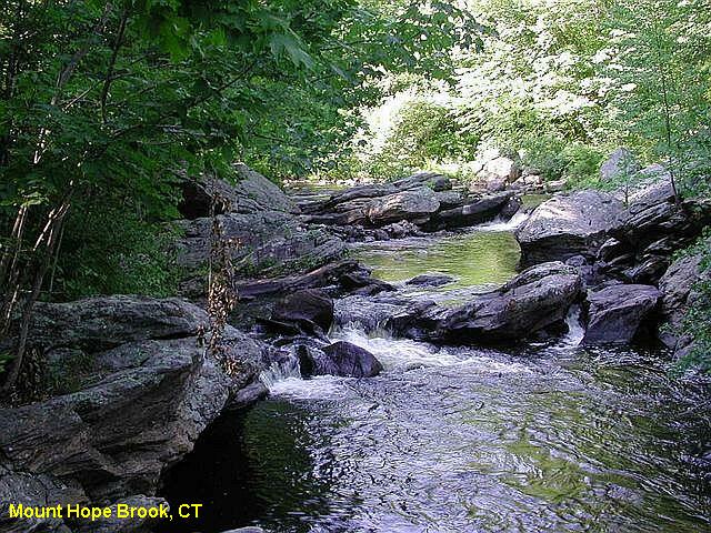
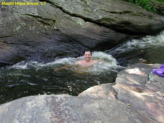
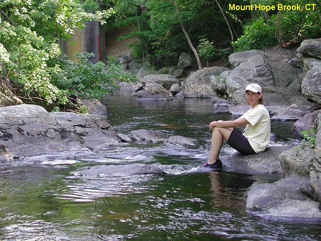
| DESCRIPTION |
Fast running
brook with wide and flat area upstream, good for wading and small
children. Further downstream there are many small falls, Jacuzzis and
whirlpools with
scattered boulders. Downstream from the small falls, there is one deep
pool (5' - 6' deep during low water) where you can actually swim just
before the brook crosses under the Atwoodville bridge. The brook is in
the sun for most of the day so it's nice and warm. There are many large
boulders for sunbathing on both the east and west banks. You can spend
all day in the water!
|
| AREAS |
Mansfield Hollow State Park |
| SANCTION |
Unofficial |
| FEE |
No |
| FACILITIES
|
None |
| ACTIVITIES |
Wading, Swimming |
| PHONE |
None |
| CAMPING |
No camping at site; camp at Mashamoquet
Brook State Park northeast of here. |
| BATHING
SUITS |
Customary |
| DIRECTIONS |
From Hartford,
take RT 6 east about 30 miles to Willimantic. In Willimantic, take RT
195 north to Mansfield Center. In Mansfield Center, take RT 89 north
about 3 miles then turn right (east) onto Atwoodville Lane. Atwood Lane
very shortly crosses a bridge, the swimming hole is here. There is NO
PARKING near the bridge just above the creek. However you can park on
Elizabeth Road or Hickory Lane about 0.2 miles further east off of
Atwoodville Lane. The creek is very near private property and the
owners do not like people parking on their land (understandably).
|
| CONFIDENCE |
Very Confident |
| VERIFIED |
Yes |
| DATE
UPDATED |
01/11/2003 |
This swimming hole listing is by
www.swimmingholes.org
RIGA FALLS
(RIGA)
|
|
| TOWNS |
SALISBURY, NORFOLK, TORRINGTON |
| LAT, LON |
Lat:42.00513
Lon:-73.45833 Source : Measured
Accuracy : Exact
Link to Google Map
|
| STATE |
CT |
| WATER |
Wachocastinook Creek |
| TYPE |
Creek |
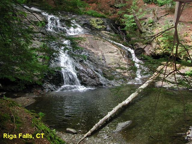
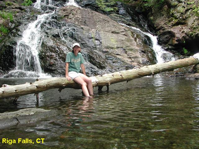
| DESCRIPTION |
Small pool at the
bottom of a very steep ravine in the Riga Falls Preserve. Very remote
and popular. The pool is not very deep, but this is a very nice place
to cool off after hiking up and down Bear Mountain. The rocks around
the falls are very slippery. Do not attempt to climb up or walk above
the falls.
|
| AREAS |
Riga Falls Preserve |
| SANCTION |
Unofficial |
| FEE |
No |
| FACILITIES
|
None |
| ACTIVITIES |
Wading |
| PHONE |
None |
| CAMPING |
No camping is allowed. |
| BATHING
SUITS |
Customary |
| DIRECTIONS |
From the
intersection of RT44 and 41 in Salisbury, follow RT 44 west into the
center of town. Just past the large white town hall building, take a
right on Washnee/Factory St. (This street apparently has two names.
I've been there and seen the street sign and still can't quite figure
it out.) Follow the signs for Mount Riga. At 0.7 miles, bear right and
continue to follow the Mount Riga signs. At 1.2 miles, this paved road
turns into a dirt road. At 1.5 miles, cross a small bridge into the
Mount Riga Preserve. Follow this narrow, windy dirt road being alert
for oncoming cars. At 2.9 miles there will be a pullout/parking area on
the right. Park here and carefully descend the steep trail down to the
water.
|
| CONFIDENCE |
Very Confident |
| VERIFIED |
Yes |
| DATE
UPDATED |
02/06/2005 |
This swimming hole listing is by
www.swimmingholes.org
SALMON RIVER
(SALM)
[1 PLACE]
|
|
| TOWNS |
HARTFORD, COLCHESTER, NORTH WESTCHESTER |
| STATE |
CT |
| WATER |
Salmon River and tributary |
| TYPE |
River |
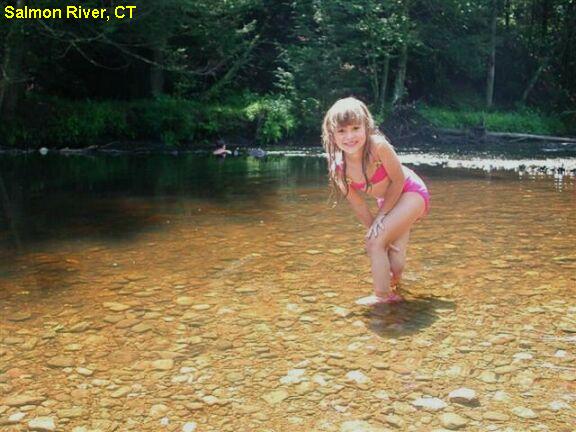
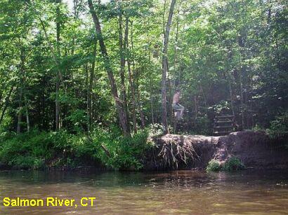
| DESCRIPTION |
In the Salmon River State Forest there
are several places to swim in the Salmon River and tributaries. For
details, see "DIRECTIONS" below. |
| AREAS |
Salmon River State Forest |
| SANCTION |
Unofficial |
| FEE |
No |
| FACILITIES
|
None |
| ACTIVITIES |
Swimming, Wading, Rope Swing |
| PHONE |
None |
| CAMPING |
No camping at site |
| BATHING
SUITS |
Customary |
| DIRECTIONS |
Take RT 2 to exit 16 (North Westchester).
Get off and turn onto RT 149 south, then:
|
SALMON RIVER [SALM]:
Travel about a mile south
on RT 149 and turn right onto River Road. Follow River Road about 1 1/2
miles to what appears to be the end at "T" intersection. At
this intersection, turn LEFT; this is still River Road. There
is a sign at this intersection declaring the Salmon River Trout
management Area. Follow River Road for approximately 0.1 mile to a
large parking lot on the right. Park here and walk down River Road, you
will pass under a large stone railway arch that now supports the
Airline Trail, a biking & hiking recreational trail. Continue
on River Road and look for the river entering into view on your left.
The swimming hole is upstream of the bend in the river. You will know
when you have found it by the presence of the rope swing on the far
shore. PHOTO
1 PHOTO 2 Lat/Lon Lat:
41.54894 Lon: -72.42442 Source: Measured Accuracy: Exact
Link to Google Map
|
|
|
| CONFIDENCE |
Very Confident |
| VERIFIED |
Yes |
| DATE
UPDATED |
8/26/2014 |
This swimming hole listing is by
www.swimmingholes.org
SCANTIC RAPIDS (SCAN)
|
|
| TOWNS |
HAZARDVILLE, ENFIELD |
| LAT, LON |
Lat:41.98184 Lon:-72.53989 Source : MapPoint
Accuracy : Exact
Link to Google Map
|
| STATE |
CT |
| WATER |
Scantic River |
| TYPE |
River |
|
DESCRIPTION |
A very fun little place on the Scantic River, the Scantic Rapids
are part of the undeveloped Scantic River State Park. PHOTO1
PHOTO2 Once the site of a gunpowder
manufacturing company owned by Augustus Hazard, this area is known
as Powder Hollow. In times of moderate flow, you can ride the
rapids downstream and end up in the large pool near the bridge. This
is a popular local spot. PHOTO3
|
| AREAS |
Basketball Hall of Fame, Stafford Motor Speedway |
| SANCTION |
Unofficial |
| FEE |
None |
| FACILITIES
|
None |
| ACTIVITIES |
Swimming, Sliding |
| PHONE |
None |
| CAMPING |
None |
| BATHING
SUITS |
Traditional |
| DIRECTIONS |
From Enfield, follow RT 190 east towards Hazardville. At the
intersection with RT 192 turn right onto South Maple Street.
Follow South Maple Street for approximately 0.4 miles to a metal
bridge. Cross the bridge and park in the pullout on the left.
There is room here for several cars. You can't miss it. |
| CONFIDENCE |
Very Confident |
| VERIFIED |
Yes |
| DATE
UPDATED |
02/03/2008 |
This swimming hole listing is by
www.swimmingholes.org
SATANS KINGDOM (SATA)
|
|
| TOWNS |
HARTFORD, CANTON, NEW HARTFORD |
| LAT, LON |
Lat:41.85831
Lon:-72.95827 Source : Measured
Accuracy : Exact
Link to Google Map
|
| STATE |
CT |
| WATER |
West Branch Farmington River |
| TYPE |
River |
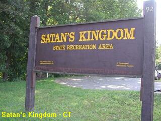
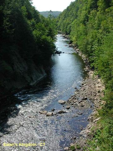
| DESCRIPTION |
Popular tubing run
in the Farmington River. Class I, II,
III whitewater rapids on a scenic stretch of river suitable for inner
tubing (with life jacket). Tube through Satan's Kingdom Gorge, a steep
drop into a narrow gorge. You will tube through some calm, wide
sections of the river where you can swim. Put-in at Satan's
Kingdom State Recreation Area, RT 44, near New Hartford. Take Out just
before the RT 202 bridge in Canton. About 2.5 miles or 2-2.5 hours.
There is a commercial tubing outfitter there or
you could use your own tubes and life jackets. The river runs parallel
to RT 44 into Canton. You could leave a bicycle or car in Canton and
ride back up RT 44 to get your car after tubing.
The business
charges for tube and life jacket rental and a bus ride back. Follow this link
for more information:
http://www.farmingtonrivertubing.com/ Those who
want to save a buck can bring their own tubes and life jackets and just
hop in the river. Be advised there could be police/conservation
officers
who will require you to wear a life jacket. At the end of the
commercial tube run, there is a small parking area where you can leave
your car or bicycle and drive
back to the Satan's Kingdom park. Most people choose to just pay the
rental fees because you don't need to coordinate anything, and don't
need two cars.
|
| AREAS |
Satan's Kingdom State Recreation Area |
| SANCTION |
Official tubing |
| FEE |
$18-$20 if you rent tubes, otherwise free. |
| FACILITIES
|
Picnic tables, toilets |
| ACTIVITIES |
Swimming, Tubing |
| PHONE |
None |
| CAMPING |
No camping at site |
| BATHING
SUITS |
Required as are life preservers if you
rent tubes |
| DIRECTIONS |
From Hartford, take RT 44 west about 20
miles to New Hartford. The Satan's Kingdom State Recreation Area is
there on RT 44. The commercial tube rental outfit is in the park. |
| CONFIDENCE |
Very Confident |
| VERIFIED |
Yes |
| DATE
UPDATED |
11/30/2003 |
This swimming hole listing is by
www.swimmingholes.org
SAUGATUCK RIVER (SAUG)
|
|
|
TOWNS |
NORWALK, WESTPORT, WESTON |
|
LAT, LON |
Lat:41.24475 Lon:-73.34905 Source : MapPoint Accuracy :
Exact
Link to Google Map |
|
STATE |
CT |
|
WATER |
Saugatuck River |
|
TYPE |
River |
|
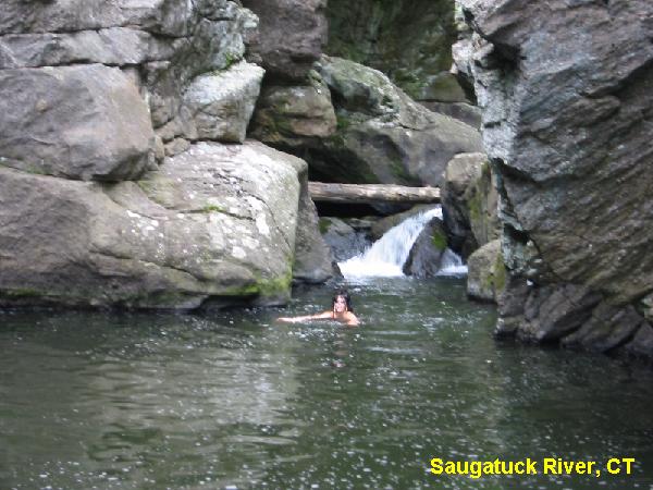
DESCRIPTION |
A visitor writes
"About two hundred yards further down the road, the river on
the right will suddenly disappear into a canyon at which point there is
a pool, waterfalls, and rocks to jump from. It is in an
unmarked park. The depth of the pool (11-25? feet) varies substantially
due to level of the river and the uneven riverbed. The water can be
shockingly cold, even in the summertime as it comes from the bottom of
the reservoir. All in all, it is a great place to go swimming on a very
hot summer day or for a quick stop for some nice scenery if in the
area. Highly Recommended." Note that some readers have reported that
the police will occasionally patrol this swimming hole and may issue
fines.
|
| AREAS |
None |
| SANCTION |
Unofficial |
| FEE |
None |
| FACILITIES
|
None |
| ACTIVITIES |
Swimming, Jumping |
| PHONE |
None |
| CAMPING |
No camping at site |
| BATHING
SUITS |
Required |
| DIRECTIONS |
Take the Merritt
Parkway to exit 42. Follow RT 57 north. At approximately 1 mile, take a
right onto Lyons Plains Rd. Almost immediately, you will come to a "Y"
intersection, bear left to remain on Lyons Plains Rd. After
approximately 2 miles you will bear left at the "Y" intersection onto
Valley Forge Rd. In about 1.5 miles, you will reach a small bridge over
the Saugatuck River. At this point the Saugatuck River emerges from the
bottom of the dam. Parking is not available at the bridge.
There is parking on the right side of the road before AFTER the hole
immediately before the dam.
|
|
CONFIDENCE |
Pretty Confident |
|
VERIFIED |
No |
|
DATE UPDATED |
01/06/2007 |
HOME
|
